[ Archive ]
| CIMSS-NOAA Weekly Report [ Archive ] |
CIMSS AND ASPB WEEKLY HIGHLIGHTS FOR THE WEEK ENDING AUGUST 25, 2023
DATA, INFORMATION, AND USE-INSPIRED SCIENCE:
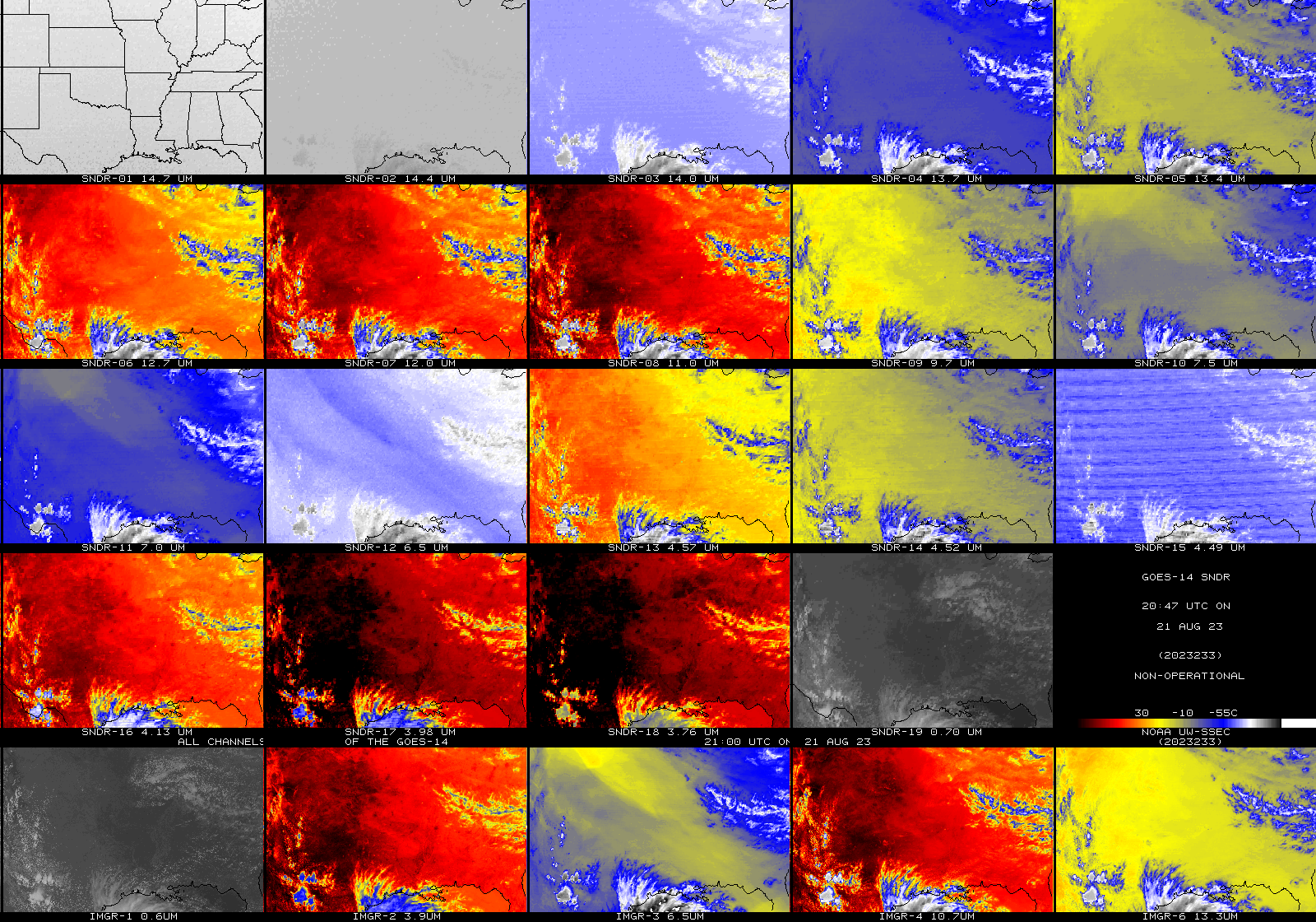
UW/SSEC Brings in GOES-14 Sounder and Imager Data: After being notified on August 21, 2023 of a flow of the non-operational GOES-14 GVAR datastream, the Space Science & Engineering Center (SSEC) Satellite Data Services (SDS) team at the University of Wisconsin-Madison was able to adjust a Patriot antenna and acquire the data. One of the purposes of the annual test is to verify image quality. The GOES-R Algorithm Working Group (AWG) Imagery Team at the Cooperative Institute for Meteorological Satellite Studies (CIMSS) tested the navigation and calibration, which appear nominal upon qualitative review. These results were briefed to the Calibration Working Group (CWG) and provided to the NWS Office of Observations and a slide set is available upon request. GOES-14 is located at approximately 108.2W and is a back-up satellite. (M. Gunshor, CIMSS, 608-263-1146, matg@ssec.wisc.edu, T. Schmit, E/RA2, 608-263-0291, tim.j.schmit@noaa.gov, J. Robaidek, SSEC, 608-262-6025)
 (Click image to enlarge)
Figure: A GOES-14 multi-band image from approximately 21 UTC on August 21, 2023. The top four rows are the 19 spectral bands of the legacy sounder (18 infrared and one visible), while the lowest row is the five bands from the Imager (one visible and four infrared).
FUTURE OUTLOOK:
AWARDS AND RECOGNITION:
TRAVEL AND MEETINGS:
TRAINING AND EDUCATION:
Quick Guide for AMSR-2 Sea Ice Concentration updated: Scott Lindstrom from the Cooperative Institute for Meteorological Satellite Studies (CIMSS) has amended the Quick Guide on an Advanced Microwave Scanning Radiometer (AMSR-2) Sea Ice Concentration product, using additional information provided by Tom Greenwald (SSEC/CIMSS). The product is being evaluated by the Alaska Sea Ice Program (ASIP) and the Quick Guide is available at this url: http://cimss.ssec.wisc.edu/goes/OCLOFactSheetPDFs/QuickGuide_AMSR2_SICv2.pdf. (T. Greenwald, S. Lindstrom, CIMSS, 608 263 4425)
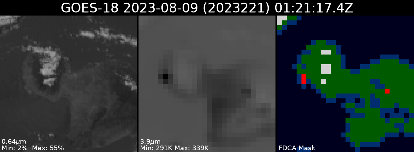
GOES Fires at the Satellite Book Club Seminar Series: Chris Schmidt of the Cooperative Institute for Meteorological Satellite Studies (CIMSS) presented “GOES Observations of Fires Big and Small” at the Satellite Book Club (SBC) Seminar Series. The SBC is hosted by the Total Operational Weather Readiness-Satellites (TOWR-S) Team from the National Weather Weather Service (NWS) Office of Observations. The fires in Maui, prescribed burns, a house fire, and the January eruption of Kīlauea were used to illustrate our evolving understanding of the GOES-R Advanced Baseline Imager’s (ABI) fire detection and monitoring capabilities. The current operational Fire Detection and Characterization Algorithm (FDCA) and upcoming Next Generation Fire System (NGFS) were featured, as well as detailed examinations of the raw ABI imagery data. It was shown that GOES ABI observations of the thermal signatures were contemporaneous with ground observations of the fire starts in Maui, that ABI readily detects prescribed burns, and that it has the sensitivity to detect an overnight residential structure fire in July in Wisconsin. The figure below shows ABI data from 9 August 2023 at 3:21 PM Hawaii time (1:21 UTC). The thermal signature from the re-emergence of the fire in Lahaina was clearly visible and was detected by the FDCA at the same time it was reported on the ground. A backcountry fire is seen to the east. The presentation was recorded and can be found on the SBC's Youtube page at https://youtu.be/mOpiJjCYkbA. (C. Schmidt, CIMSS, 608-262-7973)
 (Click image to enlarge)
Figure: Hotspots from the Lahaina and backcountry fires in Maui on 9 August 2023 as seen by ABI and the FDCA. The image was taken at 3:21 PM Hawaii time (1:21 UTC). The start time of the Lahaina fire’s re-emergence is commonly quoted as 3:20-3:25 PM, so the GOES FDCA detection was contemporaneous with the ground observations. The leftmost panel is the 0.64 μm visible band image over Maui, the center panel is the 3.9 μm “fire band” image (showing the hotspots as dark spots), and the rightmost panel is the FDCA fire metadata mask (showing the detected fires in red).
MEDIA INTERACTIONS AND REQUESTS:
SOCIAL MEDIA AND BLOG Posts:
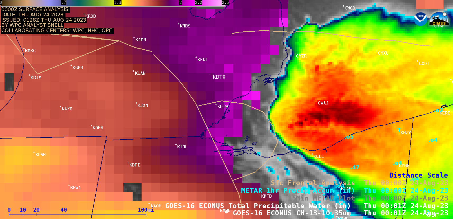
SSEC and CIMSS Scientists in the news: Scientists at the University of Wisconsin-Madison (UW) Space Science and Engineering Center (SSEC) and the Cooperative Institute for Meteorological Satellite Studies (CIMSS) provide expert interviews, imagery and case studies to promote science, document phenomena, and highlight the capabilities of software. This week: CIMSS Satellite Blog contributors Scott Lindstrom and Scott Bachmeier published these case studies: "Hurricane Hilary off the coast of Mexico" (August 18); "Creating customized brightness temperature ranges in Polar2Grid" (August 18); "Tropical Storm Hilary makes landfall in Baja California" (August 20); "Isolated ASCAT wind maxima and Himawari-9 imagery" (August 21); "Sea Ice concentration detection with AMSR-2" (August 22); "Tiger Island fire in western Louisiana" (August 22); "Heavy rainfall and flooding causes a ground stop at Detroit Metropolitan Wayne County airport". Read more at the CIMSS Satellite Blog: https://cimss.ssec.wisc.edu/satellite-blog/. (S. Lindstrom, CIMSS, 608 263 4425; S. Bachmeier, CIMSS)
 (Click image to enlarge)
Figure: GOES-16 “Clean” Infrared Window (10.3 µm) imagery overlain on Clear-sky views of GOES-16 derived Total Precipitable Water, 0000 UTC on 24 August 2023.
PUBLICATIONS:
OTHER:
| Archived Weeklies Page | Submit a report item |