[ Archive ]
| CIMSS-NOAA Weekly Report [ Archive ] |
CIMSS AND ASPB WEEKLY HIGHLIGHTS FOR THE WEEK ENDING SEPTEMBER 2, 2023
DATA, INFORMATION, AND USE-INSPIRED SCIENCE:
FUTURE OUTLOOK:
AWARDS AND RECOGNITION:
TRAVEL AND MEETINGS:
2023 AMS Summer Community Meeting: M. Gunshor, from the Cooperative Institute of Meteorological Satellite Studies (CIMSS), attended and moderated a panel at the 2023 American Meteorological Society (AMS) Summer Community Meeting held in Minneapolis, Minnesota August 29-30, 2023. Mat serves on the AMS Board of Enterprise Communications, which organizes the meeting. The Summer Community Meeting is a chance for government, industry, and academic partners to gather annually and discuss important issues facing the weather enterprise community. Since the meeting was collocated with the AMS 40th Conference on Radar Meteorology, the primary topics were about NOAA's plans for replacing the current national radar system. Speakers and panelists included industry partners, NWS forecasters, emergency managers, city public works, researchers, and multiple NOAA representatives including from NESDIS, NSSL, NWS, and OAR. (M. Gunshor, CIMSS, 608-263-1146, matg@ssec.wisc.edu)
 (Click image to enlarge)
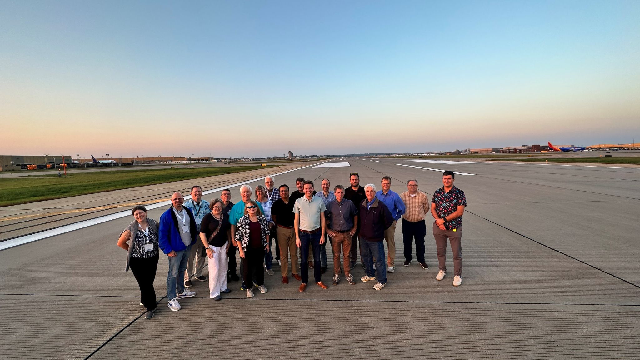
Figure: Some attendees of the 2023 AMS Summer Community Meeting went on an "insider's tour" of the Minneapolis Saint-Paul Airport and are seen here on a runway with the control tower in the background. Hosted by City of Crystal, MN Director of Public Works Mark Ray and sponsored by AccuWeather.
GOES Fires at the NE-MW Prescribed Fire Workshop: Chris Schmidt of the Cooperative Institute for Meteorological Satellite Studies (CIMSS) participated in the “Tech support for shared stewardship planning and comprehensive reporting on prescribed fires” panel at the Northeast-Midwest Prescribed Fire Science and Management Workshop (aka NE-MW Rx Fire) held at the Concourse Hotel in Madison, WI on 29-31 August 2023. The workshop brought together prescribed fire practitioners from federal, state, and local agencies, representatives of regional and statewide prescribed fire councils, and others from the non-government organization and commercial sectors to share knowledge, insights, and experiences from working with fire to manage ecosystems and fuels. The panel was chaired by John McCabe of the Forest Preserve District of Cook County and President of the Illinois Prescribed Fire Council, with whom contact had been made in February while researching unexpected fires detected by the Next Generation Fire System (NGFS) in the Chicago area. The panel presentation “Detecting Fires with Geostationary Operational Environmental Satellite (GOES)-R Advanced Baseline Imager (ABI)” gave an overview of the science of fire detection and included case studies showing the range of events detectable with ABI, from the May 2022 wildfires in New Mexico to prescribed burns and structure fires in the Midwest. Response was very positive, and a symbiotic relationship is developing where the prescribed fire practitioners will provide their data about burns. In return, CIMSS will work with them so that they may make use of ABI fire detection data to assist in tracking and cataloging the prescribed burns that are not reported to them. The gaps in reporting are a problem that everyone identified at the workshop. (C. Schmidt, CIMSS, 608-262-7973)
 (Click image to enlarge)
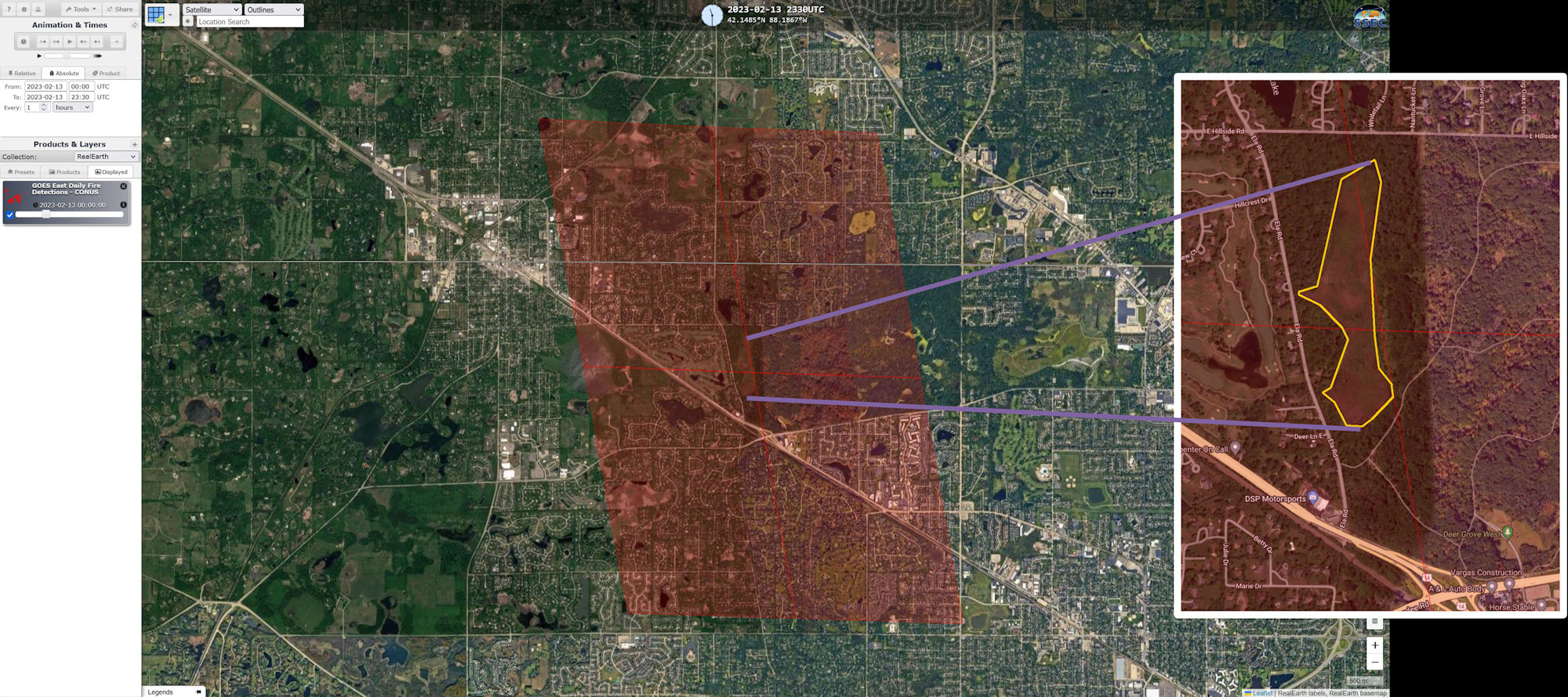
Figure: Next Generation Fire System (NGFS) detections of a prescribed burn at the Deer Grove Forest Preserve in Cook County, IL on 13 February 2023. The yellow polygon outlines the burned area perimeter, which is nicely centered on the four terrain-corrected fire pixels from the Advanced Baseline Imager (ABI). This case marks the beginning of a new collaboration between the biomass burning team at CIMSS and the prescribed fire community, which can provide an invaluable source of new validation data.
TRAINING AND EDUCATION:
MEDIA INTERACTIONS AND REQUESTS:
SOCIAL MEDIA AND BLOG Posts:
SSEC and CIMSS Scientists in the news: Scientists at the University of Wisconsin-Madison (UW) Space Science and Engineering Center (SSEC) and the Cooperative Institute for Meteorological Satellite Studies (CIMSS) provide expert interviews, imagery and case studies to promote science. This week: 1) CIMSS Scientist Jason Otkin conducted an interview with Scientific American about flash drought conditions and its impact to the Maui fires: https://bit.ly/3L3F0Ws. 2) CIMSS Scientist Derrick Herndon appeared on camera for Channel3000 about Hurricane Idalia and answered questions about hurricane intensity and its link to climate: https://bit.ly/3qVOcoW. 3) CIMSS Satellite Blog contributors Scott Lindstrom and Scott Bachmeier published these case studies: "Hurricane Idalia makes landfall along the Florida coast" (August 30), "SAR Wind observations of Hurricane Idalia" (August 30), "Day Night Band imagery of Idalia and Franklin" (August 30), "Idalia becomes a Hurricane" (August 29), "Hurricane Franklin reaches Category 4 intensity" (August 28), "Tropical Storm Idalia in the northwest Caribbean Sea" (August 27), "Satellite signatures of the NASA/SpaceX Crew-7 launch" (August 26), "Views of Tropical Storm Damrey from the Guam Direct Broadcast site" (August 26). Read more at the CIMSS Satellite Blog: https://cimss.ssec.wisc.edu/satellite-blog/. (S. Lindstrom, CIMSS, S. Bachmeier, CIMSS, E. Verbeten, SSEC)
.png) (Click image to enlarge)
(Click image to enlarge)
Figure: NOAA-20 Day Night Band visible (0.7 µm) imagery, 0704 UTC on 30 August 2023.
PUBLICATIONS:
Arctic Thermodynamic Profiling Article Published: A Cooperative Institute of Meteorological Satellite Studies (CIMSS) student lead article titled "Hyperspectral Infrared Observations of Arctic Snow, Sea Ice, and Non-Frozen Ocean from the RV Polarstern during the MOSAiC Expedition October 2019 to September 2020" was published in the journal Sensors special issue "Feature Papers in Remote Sensors 2023". This study highlights hyperspectral infrared observations from the Marine-Atmospheric Emitted Radiance Interferometer (M-AERI) developed at UW-Madison SSEC for thermodynamic profiling of the near surface using ground-based angular scanning. The Arctic snow/ice surface emissivity is derived from the M-AERI radiance observations of the surface and sky. The MOSAiC data is used to validate the NOAA Unique Combined Atmospheric Processing System (NUCAPS) vertical temperature/water vapor profiles retrieved from the NOAA-20 CrIS sensor. Citation: Nikolla, E., Knuteson, R. and Gero, J., 2023. Hyperspectral Infrared Observations of Arctic Snow, Sea Ice, and Non-Frozen Ocean from the RV Polarstern during the MOSAiC Expedition October 2019 to September 2020. Sensors, 23(12), p.5755, https://doi.org/10.3390/s23125755. (R. Knuteson, SSEC, 608-263-7974)
 (Click image to enlarge)
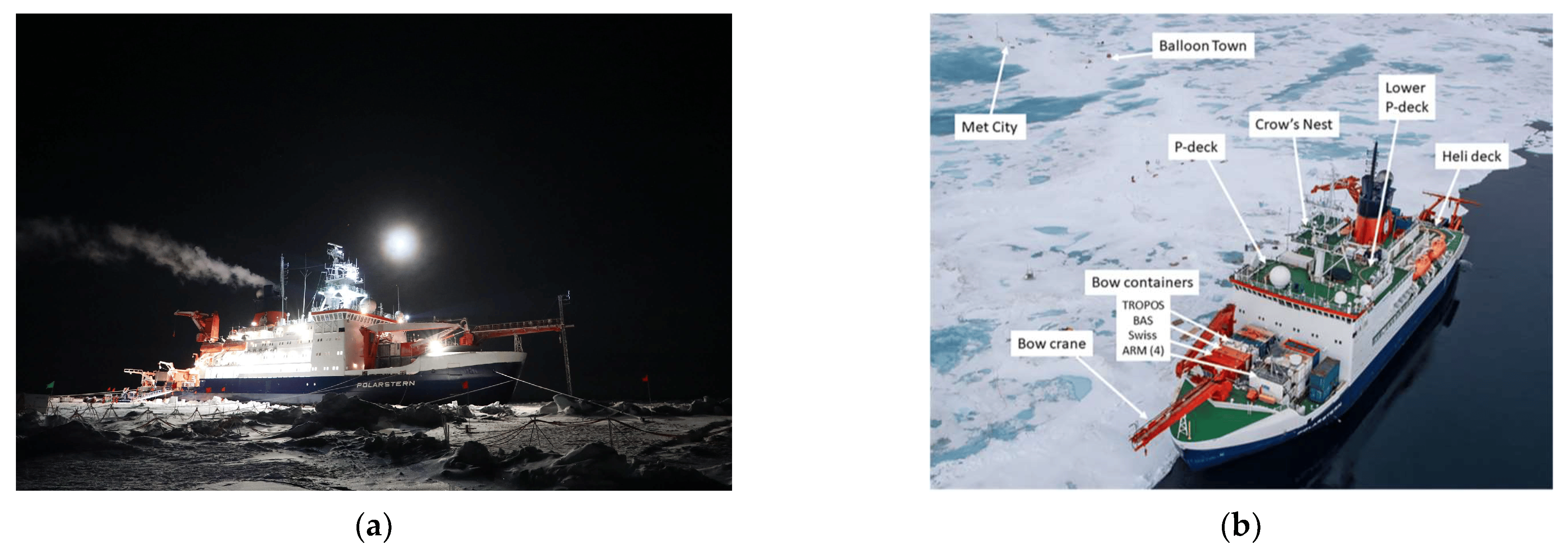
Figure: Figure: (a) RV Polarstern frozen into arctic sea ice during the MOSAiC campaign. (b) MOSAiC sensor configuration. The M-AERI is on the port-side upper P-deck in this photo.
OTHER:
| Archived Weeklies Page | Submit a report item |