[ Archive ]
| CIMSS-NOAA Weekly Report [ Archive ] |
CIMSS AND ASPB WEEKLY HIGHLIGHTS FOR THE WEEK ENDING SEPTEMBER 8, 2023
DATA, INFORMATION, AND USE-INSPIRED SCIENCE:
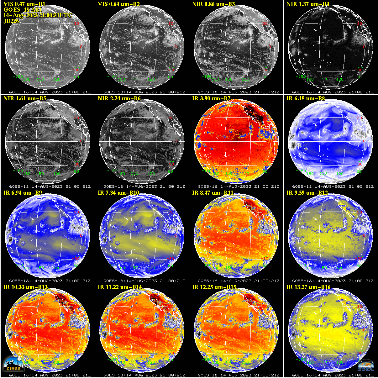
GOES-18 ABI Passes Full Maturity Validation Review: The GOES-18 Advanced Baseline Imager (ABI) Full Maturity Peer Stakeholder - Product Validation Review (PS-PVR) was held on September 1, 2023 for Level-1b Radiances and Level 2 Cloud and Moisture Imagery Product (CMIP, or "Imagery"). X. Wu (GOES-R Calibration Working Group) presented the Level 1b radiance portion of the review; T. Schmit and M. Gunshor (GOES-R Algorithm Working Group) presented the Imagery portion; J. Evans (NWS) presented the National Weather Service (NWS) perspective. The peer stakeholder committee, chaired by Andy Heidinger (NESDIS GEO Scientist) and consisting of NOAA, NASA, and NWS representatives, determined that the ABI had achieved full maturity status. The GOES-18 ABI has been in operational use since January 4, 2023. (X. Wu, STAR, Xiangqian.Wu@noaa.gov; M. Gunshor, CIMSS, matg@ssec.wisc.edu; T. Schmit, E/RA2, 608-263-0291, tim.j.schmit@noaa.gov)
 (Click image to enlarge)
Figure: An example of the 16 spectral bands on the GOES-18 Advanced Baseline Imager (ABI) from the 14 August 2023 Full Disk sector at 21:00UTC. GOES-18 ABI Radiances and Imagery were declared Full Validation maturity on September 1, 2023.
JPSS NOAA-21 VIIRS Volcanic Ash Products Declared Provisional: The Joint Polar Satellite System (JPSS) NOAA-21 Visible Infrared Imaging Radiometer Suite (VIIRS) Volcanic Ash product provisional review was held August 24, 2023. The Volcanic Ash products were deemed to be ready for the provisional stage, making the products available to end-users. The Volcanic Ash Science Team validated ash top cloud height, ash mass loading and ash detection. The Full Maturity review is scheduled for early 2024. (M. Pavolonis, NOAA/NESDIS/STAR/SMCD, 608-263-9597, michael.pavolonis@noaa.gov; J. Sieglaff, UW/CIMSS, 608-265-5357, jmsieglaff@wisc.edu, B. Andersen, UW/CIMSS, bandersen4@wisc.edu; C. Calvert, UW/CIMSS, 608-262-1023, ccalvert@ssec.wisc.edu)
FUTURE OUTLOOK:
AWARDS AND RECOGNITION:
TRAVEL AND MEETINGS:
TRAINING AND EDUCATION:
A notebook teaching how to create a lightning nowcasting model: John Cintineo of the Cooperative Institute for Meteorological Satellite Studies (CIMSS) developed a Google Colab notebook titled, "Training a Lightning Nowcasting Model with GOES-R" (https://go.wisc.edu/mcohzv). This notebook is designed to teach users basic principles of machine-learning model development, allow users to interact with GOES-R ABI and GLM data via cloud services, and to teach data preparation for training a deep-learning model using graphical processing units (GPUs). This notebook closely parallels the process of developing the ProbSevere LightningCast model, which predicts the probability of next-hour lightning using deep learning methods and GOES-R ABI inputs. The notebook was created in response to a request by NOAA's Center for Artificial Intelligence (NCAI), and supports "NOAA's AI Strategic Plan: 2021-2025" by promoting AI proficiency in the workforce. (J Cintineo, CIMSS, john.cintineo@ssec.wisc.edu).
VISIT Training on LightningCast probabilities: Scott Lindstrom from the Cooperative Institute for Meteorological Satellite Studies gave a Virtual Institute for Satellite Integration Training (VISIT) webinar to a forecaster at the National Weather Service forecast office in Wilmington Ohio. The topic was LightningCast Probabilities, a decision-support tool that is part of the ProbSevere product portfolio. LightningCast gives the likelihood of a Geostationary Lightning Mapper (GLM) observation within the next 60 minutes given the current observations from the GOES-R Advanced Baseline Imagery (ABI). (S. Lindstrom, CIMSS, 608 263 4425)
MEDIA INTERACTIONS AND REQUESTS:
SOCIAL MEDIA AND BLOG Posts:
SSEC and CIMSS Scientists in the news: Scientists at the University of Wisconsin-Madison (UW) Space Science and Engineering Center (SSEC) and the Cooperative Institute for Meteorological Satellite Studies (CIMSS) provide expert interviews, imagery and case studies to promote science. This week: CIMSS Satellite Blog contributors Scott Lindstrom and Scott Bachmeier published these case studies: "Lee intensifies to a Category 1 Hurricane, while Jova intensifies to Category 5" (September 06), "SAR observations of severe weather over western Lake Superior" (September 06), "Explosive eruption of Mount Shishaldin in Alaska" (September 05), "SAR Wind observations around Samoa" (September 04), "Typhoon Saola’s meandering path towards China" (September 02), Game Preserve Fire forces evacuations in Huntsville, Texas" (September 01). Read more at the CIMSS Satellite Blog: https://cimss.ssec.wisc.edu/satellite-blog/. (S. Lindstrom, CIMSS, S. Bachmeier, CIMSS, E. Verbeten, SSEC)
 (Click image to enlarge)
Figure: 1-minute Mesoscale Domain Sector GOES-16 (GOES-East) “Red” Visible (0.64 µm) and “Clean” Infrared Window (10.3 µm) images showed Lee as it intensified to become a Category 1 Hurricane in the Central Atlantic Ocean on 06 September 2023. The coldest cloud-top infrared brightness temperatures were around -90C (brighter white pixels embedded within darker black areas).
PUBLICATIONS:
OTHER:
| Archived Weeklies Page | Submit a report item |