[ Archive ]
| CIMSS-NOAA Weekly Report [ Archive ] |
CIMSS-NOAA WEEKLY HIGHLIGHTS FOR THE WEEK ENDING OCTOBER 6, 2023
DATA, INFORMATION, AND USE-INSPIRED SCIENCE:
FUTURE OUTLOOK:
AWARDS AND RECOGNITION:
TRAVEL AND MEETINGS:
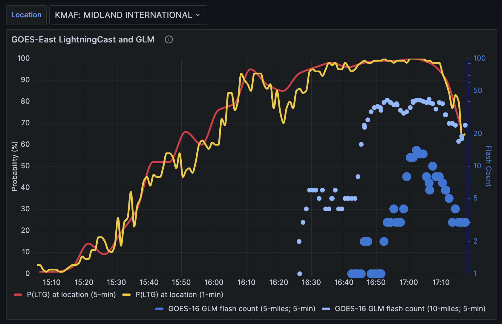
ProbSevere LightningCast presentation to National Weather Service - Eastern Region: John Cintineo of the Cooperative Institute for Meteorological Satellite Studies gave an invited presentation to NOAA's National Weather Service (NWS) Eastern Region regarding the application of ProbSevere LightningCast to their operations. LightningCast is a deep-learning/artificial intelligence model that uses GOES-R ABI data to predict the probability of lightning in the next hour at any location. The talk covered a number of topics including understanding why the model makes the predictions it does, situations where LightningCast excels or struggles, using web-based lightning dashboards, and future research and development directions. One forecaster listening in from NWS Southern Region shared a success story from 4 October 2023, where LightningCast provided elevated probabilities well before glaciation occurred in the cloud tops, and this information helped the forecaster issue an airport weather warning for Midland International Air & Space Port, giving them 25 minutes of lead time. (J. Cintineo, CIMSS, john.cintineo@ssec.wisc.edu; J. Sieglaff, CIMSS, justin.sieglaff@ssec.wisc.edu; L. Cronce, CIMSS, lee.cronce@ssec.wisc.edu; M. Pavolonis, NOAA/NESDIS/STAR, michael.pavolonis@noaa.gov)
 (Click image to enlarge)
Figure: Lightning dashboard for Midland International Air & Space Port on 4 October 2023. The red (5-min CONUS scan) and yellow (1-min MESO scan) lines show the probability of lightning, as produced by LightningCast. The blue circles show lightning observations from the Geostationary Lightning Mapper within 5 and 10 miles of the airport.
TRAINING AND EDUCATION:
FDTD Satellite Applications Webinar: Scott Lindstrom from the Cooperative Institute for Meteorological Satellite Studies (CIMSS) and Dan Bikos from the Cooperative Institute for Research in the Atmosphere (CIRA) jointly oversaw a Forecast Decision Training Division (FDTD) Satellite Applications Webinar on 4 October 2023 given by Patrick Ayd, the Science and Operations Officer (SOO) at the National Weather Service forecast office in Duluth Minnesota. The topic of Patrick's talk was Synthetic Aperture Radar (SAR) use during a severe weather event over western Lake Superior on 5 September 2023. The 15-minute talk, attended by staff from four different WFOs, was followed by a brief Question and Answer period. A recording of the talk is available at this CIRA link: https://rammb2.cira.colostate.edu/training/visit/satellite_chat/. (D. Bikos, CIRA; S. Lindstrom, CIMSS, 608 263 4425)
MEDIA INTERACTIONS AND REQUESTS:
SOCIAL MEDIA AND BLOG Posts:
SSEC and CIMSS Scientists in the news: Scientists at the University of Wisconsin-Madison (UW) Space Science and Engineering Center (SSEC) and the Cooperative Institute for Meteorological Satellite Studies (CIMSS) provide expert interviews, imagery and case studies to promote science. This week: 1) CIMSS Satellite Blog contributors Scott Lindstrom, Scott Bachmeier, and Alexa Ross published these case studies: "LightningCast probabilities in the cool season" (October 05), "Typhoon Koinu reaches Category 4 intensity as it approaches Taiwan" (October 04), "Severe Weather in North Texas" (October 04), "VIIRS views the Gulf Stream" (October 04), "Explosive eruption of Mount Shishaldin in the Aleutian Islands of Alaska" (October 03), "Sequential SAR views over Typhoon Koinu" (October 03), "Typhoon Koinu in the Philippine Sea" (October 02), "VIIRS imagery/data over the Great Lakes on 2 October 2023" (October 02), "Comparing SAR and ASCAT data south of Samoa" (October 01), "Heavy Rain over New York City" (September 29). Read more at the CIMSS Satellite Blog: https://cimss.ssec.wisc.edu/satellite-blog/. (S. Lindstrom, CIMSS, S. Bachmeier, CIMSS, A. Ross, CIMSS, 608-263-6765, E. Verbeten, SSEC)
 (Click image to enlarge)
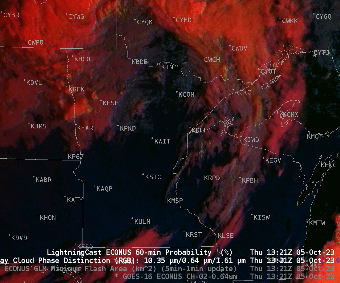
Figure: Seasonably cool Fall-like temperatures overspread the western Great Lakes and northern Plains on 5 October. The animation shows the Day Cloud Phase Distinction overlain with LightningCast probability from 1321-1721 UTC on 5 October (that is, 8:21-12:21 CDT).
PUBLICATIONS:
OTHER:
| Archived Weeklies Page | Submit a report item |