[ Archive ]
| CIMSS-NOAA Weekly Report [ Archive ] |
CIMSS-NOAA WEEKLY HIGHLIGHTS FOR THE WEEK ENDING OCTOBER 27, 2023
DATA, INFORMATION, AND USE-INSPIRED SCIENCE:
NOAA-21 Ice Surface Temperature and Concentration Maturity Review: The NOAA and Cooperative Institute for Meteorological Satellite Studies (CIMSS) Cryosphere Team presented an assessment of two VIIRS ice products at a NOAA-21 Provisional Maturity Review on 26 October 2023. The products include Ice Surface Temperature and Ice Concentration. An Ice Thickness and Age review will be held at a later date. Rich Dworak, CIMSS, gave the presentation on behalf of the Team. The validation studies demonstrated that both products meet the criteria for Provisional Maturity. Beta and Provisional Maturity products can be distributed by NOAA's Comprehensive Large Array-Data Stewardship System (CLASS). (J. Key, E/RA2, 608-263-2605, jeff.key@noaa.gov; R. Dworak, CIMSS, 608-265-8620; Y. Liu, E/RA2, 608-890-1893, yinghui.liu@noaa.gov)
FUTURE OUTLOOK:
AWARDS AND RECOGNITION:
TRAVEL AND MEETINGS:
TRAINING AND EDUCATION:
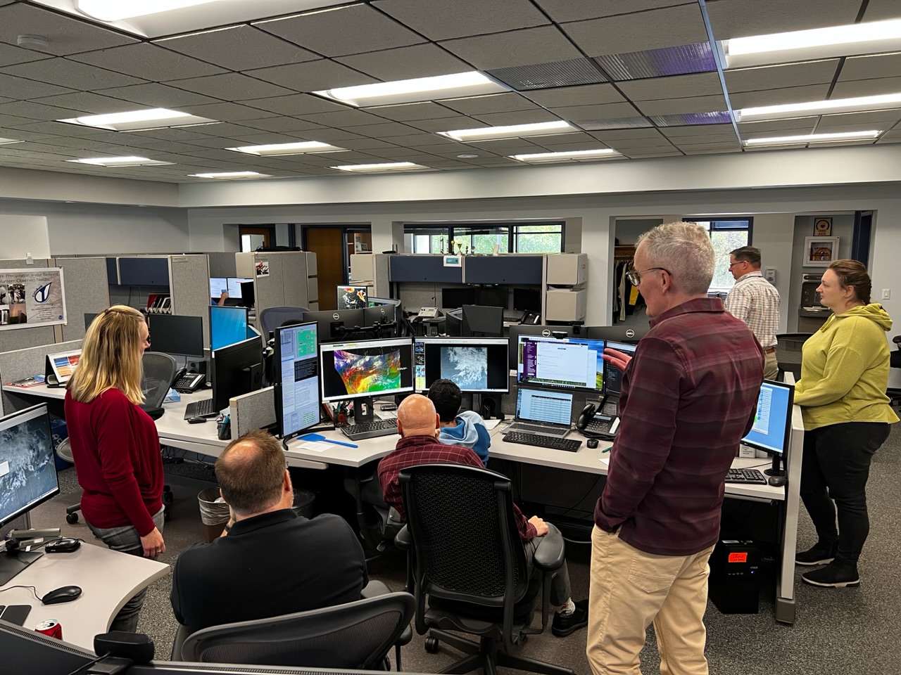
CIMSS Provides In-person training at WFO MKX: Scott Lindstrom (UW-Madison) and Tim Schmit (NOAA STAR), both at the Cooperative Institute for Meteorological Satellite Studies (CIMSS), were at the National Weather Service Forecast office in Sullivan, WI (WFO MKX) to give in-person training on Satellite Imagery and Products. Topics covered included various ways to view Satellite imagery in AWIPS, different satellite products that can be used for specific weather events, and what GeoXO might offer to forecasters in the distant future. The two-hour give-and-take discussion was preceded and followed by individual discussions with forecasters on different AWIPS procedures they might use for viewing satellite imagery. As a followup, a Google Document that detailed different satellite products to use for different weather events was created ("Event-Based Satellite Product Suggestions" on the NOAA Google drive) (S. Lindstrom, CIMSS, 608 263 4425; Tim Schmit NOAA/STAR)
 (Click image to enlarge)
Figure: Scott Lindstrom, CIMSS, discusses an Airmass RGB image on AWIPS, detailing the different features that are apparent and how they might related to Potential Vorticity, as NWS forecasters listen (Photo Credit: Tim Schmit, NOAA/STAR)
New GOES-R Quick Guide on Snow Fraction developed: Scott Lindstrom from the Cooperative Institute for Meteorological Satellite Studies (CIMSS), in a collaboration with Peter Romanov (CUNY/CREST/NOAA) and Jeff Key (NOAA/STAR) created a new GOES-R Quick Guide for the Snow Fraction product that is scheduled to be included in the next build of AWIPS within National Weather Service forecast offices. The request for the Quick Guide came from TOWR-S and FDTD. The Quick Guide is available here: https://cimss.ssec.wisc.edu/goes/OCLOFactSheetPDFs/QuickGuide_GOESR_SnowFraction.pdf. (S. Lindstrom, CIMSS, 608 263 4425)
MEDIA INTERACTIONS AND REQUESTS:
SOCIAL MEDIA AND BLOG Posts:
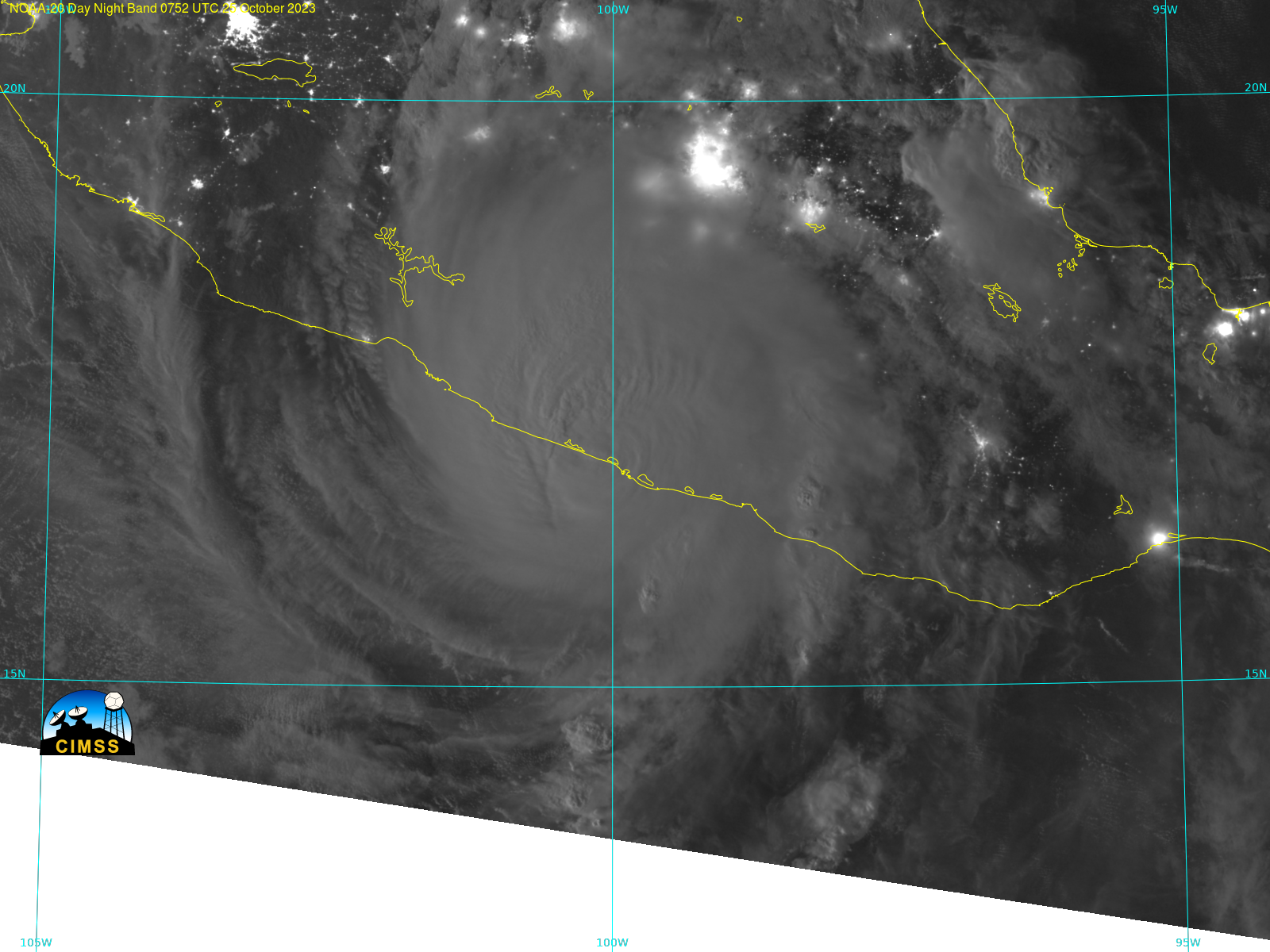
SSEC and CIMSS Scientists in the news: Scientists at the University of Wisconsin-Madison (UW) Space Science and Engineering Center (SSEC) and the Cooperative Institute for Meteorological Satellite Studies (CIMSS) provide expert interviews, imagery and case studies to promote science. This week: 1) CIMSS Satellite Blog contributors Scott Bachmeier, Alexa Ross and Scott Lindstrom published these case studies: “Resuspended volcanic ash from Mount Aniakchak in Alaska” (October 26) “Typhoon Lola seen from Himawari” (October 25), “Cat 5 Hurricane Otis from the Wisconsin Direct Broadcast site” (October 25), “Hurricane Otis rapidly intensifies to Category 5, just prior to making landfall near Acapulco, Mexico” (October 24), “Severe Tropical Cyclone Lola in the southwest Pacific” (October 24), "Super Fog causes multi-vehicle accidents along Interstate 55 in Louisiana" (October 23), "Cyclone Tej in the Arabian Sea" (October 22), "Plume of airborne glacial silt from the Copper River Valley in southcentral Alaska" (October 22), "Strong cold frontal high wind event across the Northern Plains" (October 17). Read more at the CIMSS Satellite Blog: https://cimss.ssec.wisc.edu/satellite-blog/. (S. Lindstrom, CIMSS, 608 263 4425; S. Bachmeier, A. Ross)
 (Click image to enlarge)
Figure: NOAA-20 VIIRS Day Night Band imagery of Hurricane Otis shortly after landfall at Acapulco, Mexico on 25 October 2023. NOAA-20 data are from Direct Broadcast and were processed using CSPP software.
PUBLICATIONS:
OTHER:
| Archived Weeklies Page | Submit a report item |