[ Archive ]
| CIMSS-NOAA Weekly Report [ Archive ] |
CIMSS-NOAA WEEKLY HIGHLIGHTS FOR THE WEEK ENDING NOVEMBER 3, 2023
DATA, INFORMATION, AND USE-INSPIRED SCIENCE:
NOAA-21 Cloud Products Reach Beta and Provisional Maturity Status: The NOAA/NESDIS/Center for Satellite Applications and Research (STAR) Cloud Products Team - composed of Cooperative Institute for Meteorological Satellite Studies (CIMSS) at the University of Wisconsin-Madison, Cooperative Institute for Research in the Atmosphere (CIRA) and STAR scientists - presented various operational product assessments at a NOAA-21 Beta and Provisional Maturity Review that was held on 26 October 2023. The cloud products assessed were the Enterprise Cloud Mask, Cloud Top Phase/Type, Cloud Top Height/Pressure/Temperature, Cloud Cover Layers, and Cloud Base Height. The Cloud Optical and Microphysical Properties review will be held on 30 November 2023. Presenters included Yue Li (CIMSS), Coda Phillips (CIMSS), Steve Wanzong (CIMSS), John Haynes (CIRA), and Mark Kulie (STAR). The analyses presented demonstrated that all products meet the criteria to receive Provisional (Cloud Mask) and Beta/Provisional Maturity (Cloud Top Phase/Type, Cloud Top Height/Pressure/Temperature, Cloud Cover Layers, and Cloud Base Height) status. All of these products were recently declared ready for distribution for operational users. (M. Kulie, E/RA2, 608-263-6583, mark.kulie@noaa.gov)
FUTURE OUTLOOK:
AWARDS AND RECOGNITION:
TRAVEL AND MEETINGS:
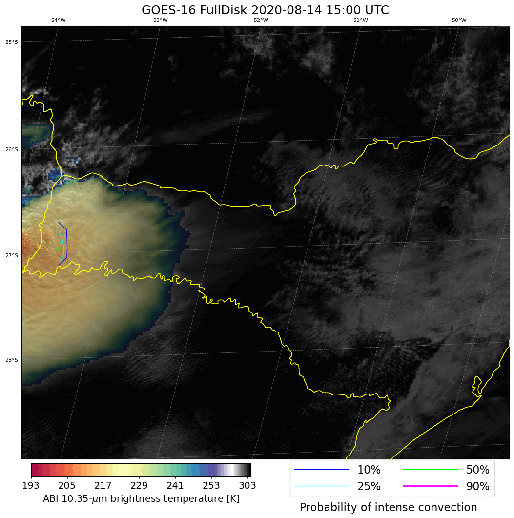
ProbSevere for WMO RAIII Nowcasting Workshop: John Cintineo of the Cooperative Institute for Meteorological Satellite Studies (CIMSS) provided output from the ProbSevere LightningCast and ProbSevere IntenseStormNet models for specific thunderstorm cases in Brazil in support of a World Meteorological Organization (WMO) Regional Association III (RAIII) workshop on nowcasting. The workshop is in the planning stages and is a collaboration between the WMO, scientists in South America, and the Cooperative Program for Operational Meteorology, Education, and Training (COMET). General instruction and interpretation on the models was also provided. LightningCast is an artificial-intelligence (AI) model that uses GOES-R Advanced Baseline Imager (ABI) images to predict the probability of lightning in the next hour at any given location. IntenseStormNet is also an image-based AI model that uses ABI and Geostationary Lightning Mapper (GLM) images to detect the most intense areas of convection. IntenseStormNet is adept at detecting developing supercell-like features in satellite imagery. Both LightningCast and IntenseStormNet have applicability to regions outside of the U.S. because they were constructed to use solely GOES-R imagery. (J. Cintineo, CIMSS, john.cintineo@ssec.wisc.edu).
 (Click image to enlarge)
Figure: Probabilities of "intense" convection for storms in southern Brazil (contours) on 14 August 2020. Imagery is a combination of the 0.64-µm reflectance and 10.3-µm brightness temperature, commonly referred to as "CH02 and CH13 sandwich" imagery. These storms produced large hail and tornadoes.
TRAINING AND EDUCATION:
MEDIA INTERACTIONS AND REQUESTS:
SOCIAL MEDIA AND BLOG Posts:
PUBLICATIONS:
OTHER:
| Archived Weeklies Page | Submit a report item |