[ Archive ]
| CIMSS-NOAA Weekly Report [ Archive ] |
CIMSS-NOAA WEEKLY HIGHLIGHTS FOR THE WEEK ENDING FEBRUARY 23, 2024
DATA, INFORMATION, AND USE-INSPIRED SCIENCE:
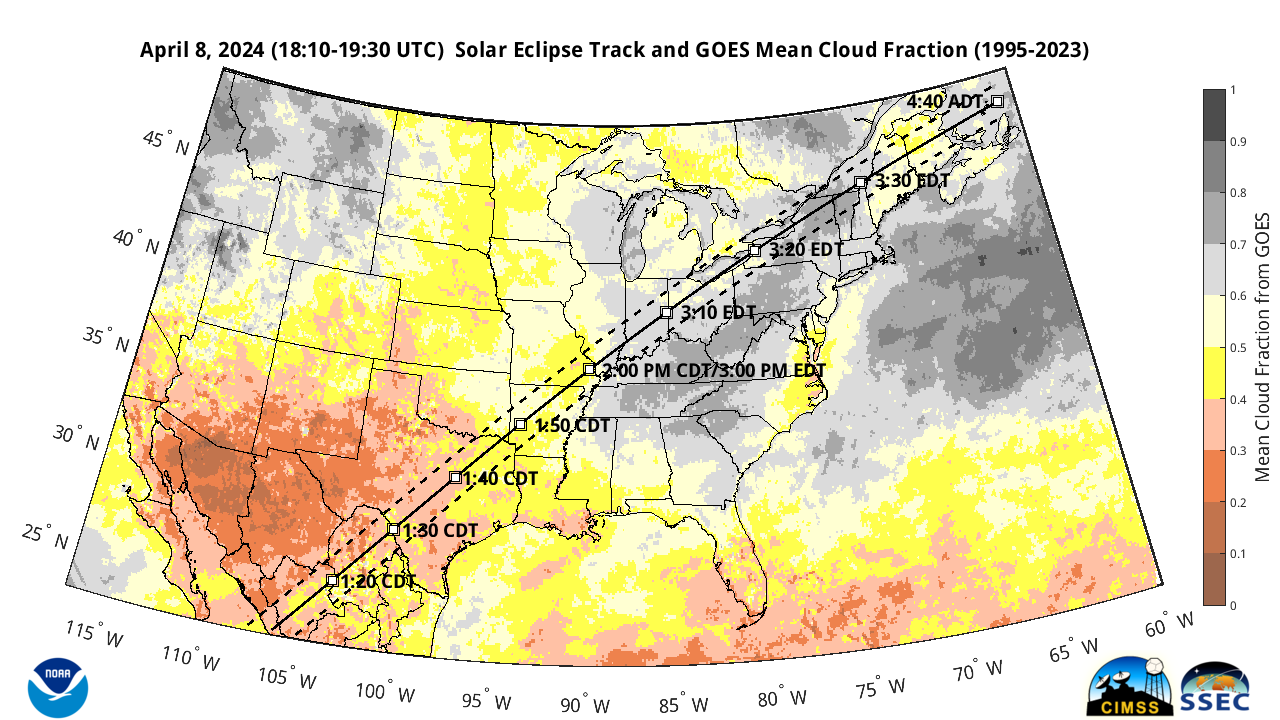
CIMSS Provides GOES Cloud Climatology for April 08 Eclipse: Researchers at the Cooperative Institute for Meteorological Satellite Studies (CIMSS) posted a blog (https://cimss.ssec.wisc.edu/satellite-blog/archives/57278) highlighting a dataset that CIMSS generated for an April 8 cloud climatology in anticipation of the upcoming eclipse. The dataset is based on Geostationary Operational Environmental Satellite (GOES) Imager data from 1995-2023, where several hours of cloud data on April 8 of every year since 1995 where taken from the Enterprise Cloud Products produced using NOAA’s Clouds from AVHRR Extended (CLAVR-x) processing framework at the University of Wisconsin, CIMSS (https://cimss.ssec.wisc.edu/clavrx/). The cloud fraction product was remapped to a gridded dataset so that the data from different imagers, which included GOES-8, GOES-12, GOES-13, and GOES-16 with their different spatial coverages and spatial resolutions, could be averaged. The average cloud fraction product provides the public with a general idea of how cloudy it has been historically along the Total Solar Eclipse path for April 8, 2024. A January 19th CIMSS Blog post (https://cimss.ssec.wisc.edu/satellite-blog/archives/56516) on this topic garnered the attention of a reporter at the Washington Post, who requested the data from CIMSS and generated their own graphics and story that was published online on February 22, 2024 (https://www.washingtonpost.com/weather/2024/02/22/april-eclipse-clouds/. (M. Gunshor, CIMSS, 608-263-1146, S. Wanzong, CIMSS,T. Schmit, E/RA2, 608-263-0291, tim.j.schmit@noaa.gov)
 (Click image to enlarge)
Figure: Mean GOES Cloud Fraction from 1995-2023 on April 8th. Eclipse track shows the path of solar eclipse totality for April 8, 2024 and locations of totality with times in local time zones.
FUTURE OUTLOOK:
AWARDS AND RECOGNITION:
TRAVEL AND MEETINGS:
UW CIMSS & SSEC POLAR/LEO Poster Session: Scientists at the University of Wisconsin-Madison (UW) Space Science and Engineering Center (SSEC) and the Cooperative Institute for Meteorological Satellite Studies (CIMSS) met this week to discuss ongoing POLAR/LEO related research within the Center and Cooperative Institute. Recent AGU and AMS posters and oral presentations were displayed and discussed. More details on these efforts are found below and on the CIMSS Satellite Blog at https://cimss.ssec.wisc.edu/satellite-blog/archives/57290. The posters and presentations were:
(S. Lindstrom, scottl@ssec.wisc.edu)
TRAINING AND EDUCATION:
MEDIA INTERACTIONS AND REQUESTS:
SOCIAL MEDIA AND BLOG Posts:
SSEC and CIMSS Scientists in the news: Scientists at the University of Wisconsin-Madison (UW) Space Science and Engineering Center (SSEC) and the Cooperative Institute for Meteorological Satellite Studies (CIMSS) provide expert interviews, imagery and case studies to promote science and satellite imagery. This week: 1) CIMSS Satellite Blog contributors Scott Bachmeier, Scott Lindstrom, and Mat Gunshor published the following case studies: "How altimetry observations change from day to day" (February 22); "Updating GOES Cloud Climatology for the April 8, 2024 Total Solar Eclipse" (February 22); "CIMSS and JPSS at AMS in 2024: Part I" (February 22); "Eruption of Popocatépetl in Mexico" (February 21); "Tropical Storm Akará develops off the southeast coast of Brazil" (Februrary 18). Read more at the CIMSS Satellite Blog: https://cimss.ssec.wisc.edu/satellite-blog/. (S. Lindstrom, CIMSS, 608-263-4425; S. Bachmeier, CIMSS; M. Gunshor, CIMSS, 608-263-1146; E. Verbeten, SSEC, 608-263-4206.
 (Click image to enlarge)
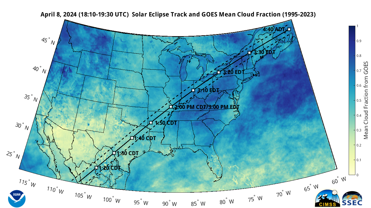
Figure: Mean GOES Cloud Fraction from 1995 – 2023 on April 8th. Probably still not suitable for framing. Eclipse track shows the path of solar eclipse totality for April 8, 2024 and locations of totality with times in local time zones.
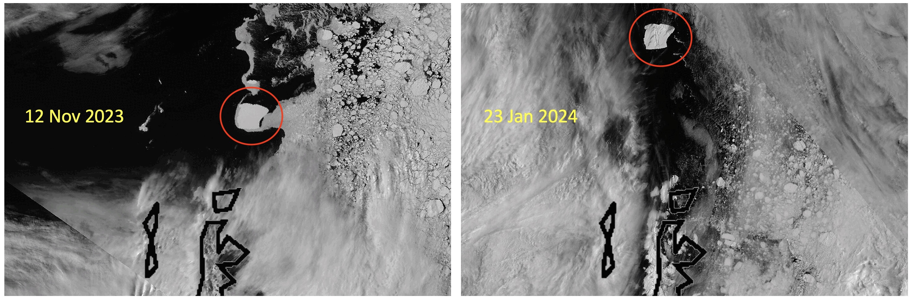
New CIMSS satellite blog on monitoring Iceberg A-23a: Scott Bachmeier published a blog post titled "Update on the motion of Antarctic Iceberg A23a" at https://cimss.ssec.wisc.edu/satellite-blog/archives/57332. This post updates the locations of the Iceberg A23-a from 1 November 2023 to 19 February 2024 using VIIRS 0.64 µm daily composite images and GOES-16 True Color RGB images. It shows an iceberg rotation near the end of this time period that resulted from a combination of winds and ocean currents. The VIIRS ice surface temperature product shows near or just below freezing at the surface of the iceberg. (Y. Liu, E/RA2, 608-890-1893, yinghui.liu@noaa.gov; S. Bachmeier, CIMSS, 608-263-3958)
 (Click image to enlarge)
Figure: NOAA-20 VIIRS images of iceberg A23a off the tip of the Antarctic Peninsula on 12 November 2023 (left) and 23 January 2024 (right).
PUBLICATIONS:
OTHER:
| Archived Weeklies Page | Submit a report item |