[ Archive ]
| CIMSS-NOAA Weekly Report [ Archive ] |
CIMSS-NOAA WEEKLY HIGHLIGHTS FOR THE WEEK ENDING APRIL 5, 2024
DATA, INFORMATION, AND USE-INSPIRED SCIENCE:
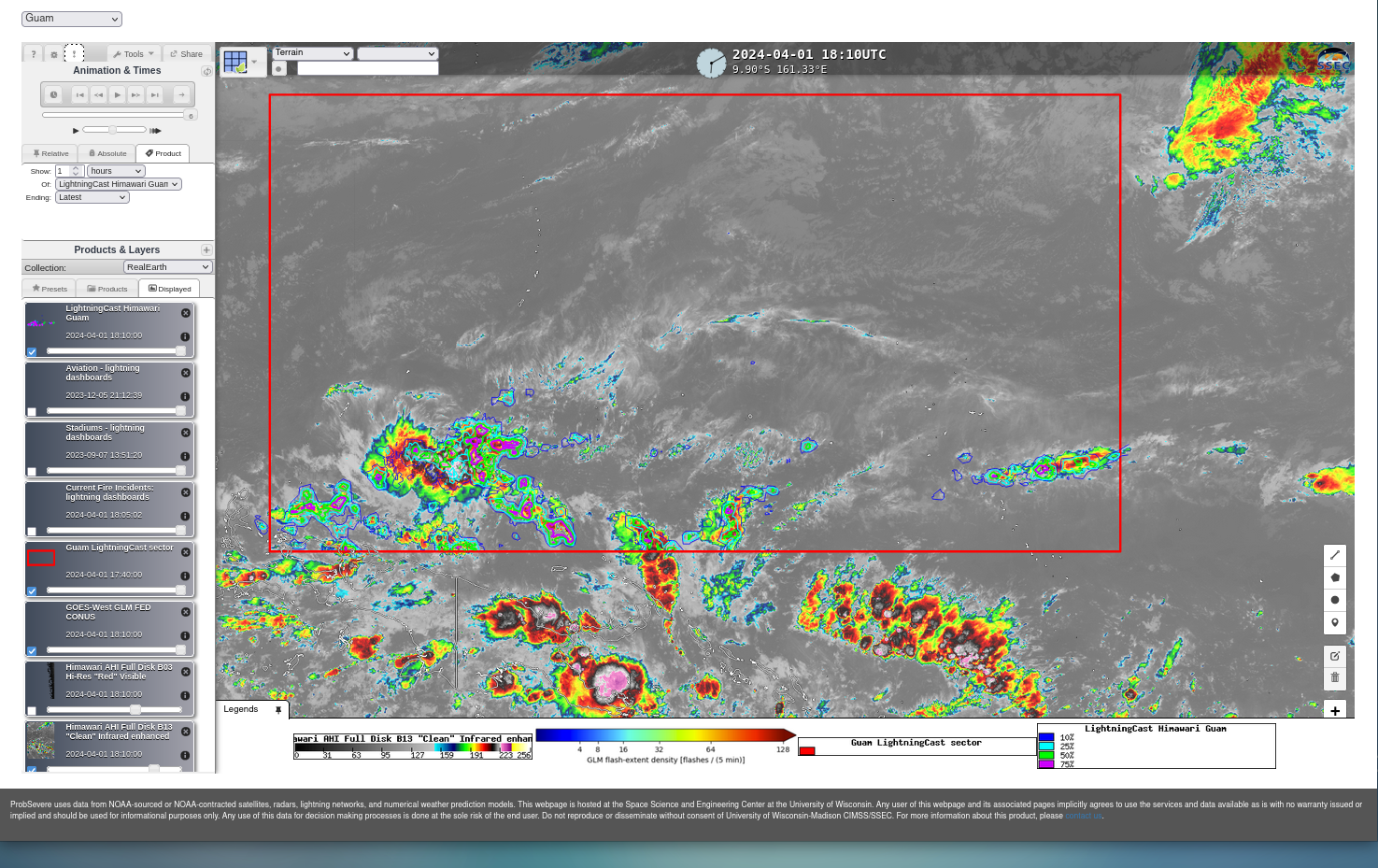
UW CIMSS ProbSevere LightningCast Probability domain increased for WFO Guam: In part as a consequence of Community Satellite Processing Package Geo (CSPP Geo) work on a stand-alone version of software that computes LightningCast Probability given radiance input from GOES-R/Himawari-9 data, John Cintineo from the Cooperative Institute for Meteorological Satellite Studies (CIMSS) has modified the region over which LightningCast Probability is computed over Guam. The domain has been enlarged from the Marianas Islands to the entire Guam National Weather Service Area Of Responsibility (AOR). Data are available online in the 'Guam Sector' at this website https://cimss.ssec.wisc.edu/severe_conv/pltg.html ; CIMSS also supplies AWIPS tiles to the National Weather Service Pacific Region. This change was coordinated with Eric Jacobsen, NWS PRH. For more information, including figures, refer to this CIMSS Satellite Blog Post: https://cimss.ssec.wisc.edu/satellite-blog/archives/58071. (S. Lindstrom, J. Cintineo, CIMSS; E. Jacobsen, NWS PRH)
 (Click image to enlarge)
Figure: The Red Rectangle shows the new domain over which LightningCast probabilities are now computed from Himawari-9 data. The area covers the Marianas and Marshall Islands, and much of Micronesia.
FUTURE OUTLOOK:
AWARDS AND RECOGNITION:
TRAVEL AND MEETINGS:
TRAINING AND EDUCATION:
MEDIA INTERACTIONS AND REQUESTS:
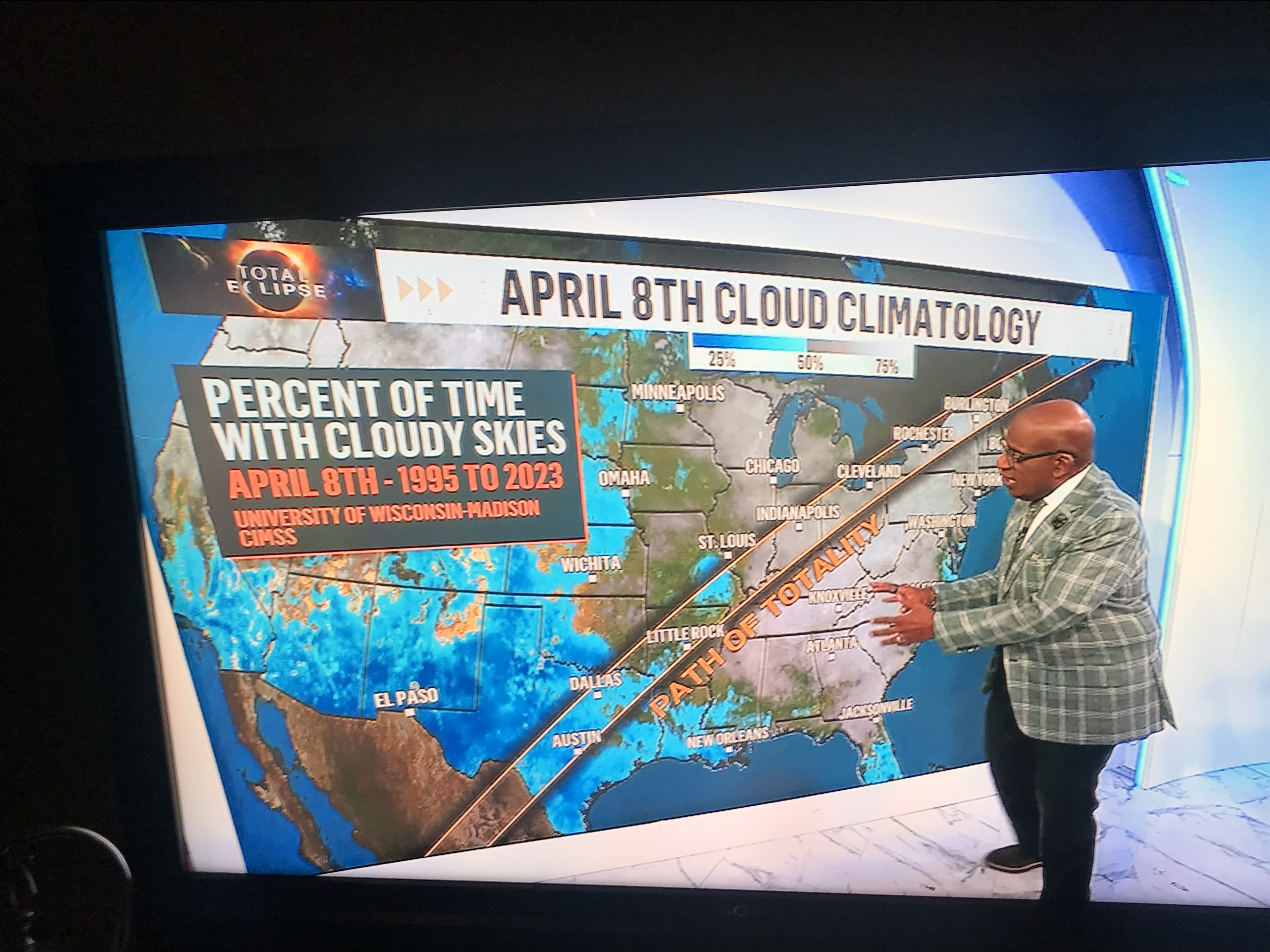
Al Roker shows GOES Cloud Climatology for April 08 Eclipse on The Today Show: Researchers at the Cooperative Institute for Meteorological Satellite Studies (CIMSS) provided data to a meteorologist at NBC News. The data appeared on the CIMSS satellite blog (https://cimss.ssec.wisc.edu/satellite-blog/archives/57278) highlighting a dataset that CIMSS generated for an April 8 cloud climatology in anticipation of the April 8, 2024 total solar eclipse. The dataset is based on GOES Imager data from 1995-2023, where several hours of cloud data on April 8 of every year since 1995 were used in the Enterprise Cloud Products algorithm produced using NOAA’s Clouds from AVHRR Extended (CLAVR-x) processing framework at the University of Wisconsin, CIMSS (https://cimss.ssec.wisc.edu/clavrx/). The cloud fraction product was remapped to a gridded dataset so that the data from different imagers, which included GOES-8, GOES-12, GOES-13, and GOES-16 with their different spatial coverages and spatial resolutions, could be averaged. The average cloud fraction product provides the public with a general idea of how cloudy it has been historically along the Total Solar Eclipse path for April 8, 2024. The CIMSS blog on this topic garnered the attention of a NBC meteorologist who works on the Today show, who requested the data from CIMSS, generated their own graphics, and a story was presented by Al Roker on television April 2, 2024. (M. Gunshor, CIMSS, 608-263-1146, S. Wanzong, CIMSS,T. Schmit, E/RA2, 608-263-0291, tim.j.schmit@noaa.gov)
 (Click image to enlarge)
Figure: Television personality Al Roker showing the GOES cloud climatology for April 8 on the Today show April 2, 2024. (Photo credit: Jaime Daniels, NOAA/NESDIS/STAR).
SOCIAL MEDIA AND BLOG Posts:
SSEC and CIMSS Scientists in the news: Scientists at the University of Wisconsin-Madison (UW) Space Science and Engineering Center (SSEC) and the Cooperative Institute for Meteorological Satellite Studies (CIMSS) provide expert interviews, imagery and case studies to promote science and satellite imagery. This week: 1) CIMSS Satellite Blog contributors Scott Bachmeier and Scott Lindstrom, and NOAA Scientist Tim Schmit published the following case studies: "Prescribed burning in the Flint Hills of Kansas and Oklahoma" (April 04); "The North American Total Eclipse of April 2024" (April 04); "Gridded NUCAPS from two different satellites" (April 04); "GOES Mesoscale Requests for April 8th" (April 03); "S50th Anniversary of the 1974 Super Outbreak" (April 03); "Thundersnow in southern Wisconsin" (April 02); "PHS Model Output and severe weather in Kentucky" (April 02); "Change in CIMSS Direct Broadcast displays for NUCAPS HEAP pressure level analyses" (April 01); "64th anniversary of the first image from a meteorological satellite" (April 01); "United Airlines Flight 85 diverted after encountering severe turbulence (which injured 22 passengers)" (March 29); "VIIRS SSTs and Day Night Band imagery, late March 2024" (March 29) "LightningCast probabilities over Australia" (March 29). Read more at the CIMSS Satellite Blog: https://cimss.ssec.wisc.edu/satellite-blog/. 2)SSEC Scientist Tim Wagner conducted an interview with WMTV 15 News discussing ways researchers at SSEC and CIMSS will study the atmospheric impacts caused by the April 08, 2024 solar eclipse using the SSEC Portable Atmospheric Research Center, or SPARC: https://www.wmtv15news.com/2024/03/27/wisconsinites-making-trek-totality/. (S. Lindstrom, CIMSS, 608-263-4425; S. Bachmeier, CIMSS; T. Schmit, E/RA2, 608-263-0291, tim.j.schmit@noaa.gov; E. Verbeten, SSEC, 608-263-4206.
 (Click image to enlarge)
Figure: Real-time animations of the Eclipse will be available at the website shown above, https://www.ssec.wisc.edu/datacenter/eclipse2024/ -- Animations will include ABI and SUVI data.
PUBLICATIONS:
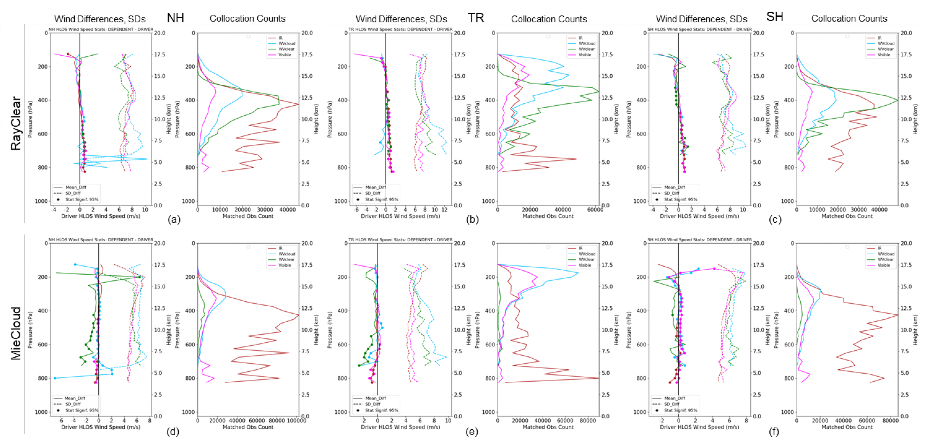
Archive and software for the intercomparison of winds published: The following paper has been published: Lukens, K.E.; Garrett, K.; Ide, K.; Santek, D.; Hoover, B.; Huber, D.; Hoffman, R.N.; Liu, H. System for Analysis of Wind Collocations (SAWC): A Novel Archive and Collocation Software Application for the Intercomparison of Winds from Multiple Observing Platforms. Meteorology, 2024, 3, 114-140, https://doi.org/10.3390/meteorology3010006. This paper describes a several-year archive of various wind observations and software for multivariate collocation and analysis. The data consists of global 3D winds observed by Aeolus, sondes, aircraft, stratospheric balloons, and satellite-derived atmospheric motion vectors (AMVs) which are uniformly formatted in netCDF. A downloadable software application is provided to interactively collocate and statistically compare wind observations. An example comparison plot is shown in the figure. (D. Santek, CIMSS, 608-263-7410)
 (Click image to enlarge)
Figure: A comparison of Aeolus Rayleigh clear and Mie cloudy winds with IR, visible, water vapor cloud, and water vapor clear AMVs.
OTHER:
Yuuki Saeki's visit: Yuuki Saeki, from the Japan Meteorological Agency, arrived at the University of Wisconsin-Madison Cooperative Institute for Meteorological Satellite Studies (CIMSS) to begin a year-long visit. The purpose of the visit is to better prepare for Japan’s advanced infrared Geostationary HiMawari Sounder (GHMS) which is slated for launch later this decade. A kickoff meeting was held to welcome him and meet with CIMSS scientists working on hyperspectral IR sounders, SSEC director along with a few STAR/NESDIS/NOAA scientists. Plans have been made to help facilitate Yuuki’s visit. ( Z. Li, CIMSS, 608-890-1982; T. Schmit, E/RA2, 608-263-0291, tim.j.schmit@noaa.gov; A. Heidinger E/RA2, 608-263-6757, andrew.heidinger@noaa.gov; Yuuki Saeki, CIMSS, ysaeki@wisc.edu)
| Archived Weeklies Page | Submit a report item |