The Polar Radiation Flux project provides 3-hourly flux coverage for the arctic and antarctic regions, above 57.5 degrees latitude, for years of available data (currently, 1985-1993). The fluxes (W/m2) in the data set are:
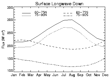
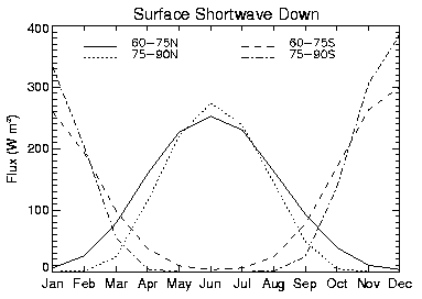
Sample results are shown in figures below. The first two figures illustrate the seasonal cycles of downwelling shortwave and longwave radiation for two latitude zones in each polar region. Results agree well with surface observations (not shown), and the longwave results are much improved over our previous flux dataset that was based on the ISCCP C2 (rather than D1) cloud data.
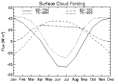
The next figure shows the seasonal cycle of the cloud radiative
effect, also called the cloud "forcing", at the surface for the same latitude
zones. As expected, the forcing is positive during the polar night
and negative during the summer.
Perhaps less expected is the positive
cloud forcing during the spring and fall, when both solar and terrestrial
radiation are present but when the solar zenith angles are large.
This effect is more prolonged at higher latitudes where solar zenith angles
are larger and surface albedo is higher. Note that the net cloud forcing
over the continent of Antarctica is nearly always positive in the monthly mean,
as a result of this solar zenith angle-high surface albedo combination.
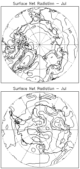
The figure below shows the spatial distribution of net radiation at the surface during the month of July, which is the northern hemisphere summer (top), and southern hemisphere winter (bottom). Latitudinal and topographic dependencies are evident in both hemispheres.
For more details, and to access the daily and monthly average data, click here.
This research is being (or was) performed by the following people: Jeff Key, Veronica Fisher, Dan Slayback, and Michael Pavolonis.
Schweiger, A.J., R. Lindsay, J. Key, and J. Francis, 1999. Arctic clouds in multiyear satellite data sets, Geophys. Res. Lett., 24(5), 443-451.
Key, J., D. Slayback, C. Xu, and A. Schweiger, 1999. New climatologies of polar clouds and radiation based on the ISCCP "D" products. Proceedings of the Fifth Conference on Polar Meteorology and Oceanography, American Meteorological Society, Dallas, TX, January 10-15, 227-232.
Key, J. and A.J. Schweiger, 1998. Tools for atmospheric radiative transfer: Streamer and FluxNet. Computers and Geosciences, 24(5), 443-451.
Serreze, M.C., J. Box, and J. Key, 1998. A new monthly climatology of global radiation for the Arctic and comparisons with NCEP/NCAR reanalysis and ISCCP-C2 fields. J. Climate, 11(2), 121-136.
Schweiger, A.J. and J. Key, 1994. Arctic Ocean radiation fluxes and cloud forcing based on the ISCCP C2 cloud data set, 1983-90. J. Appl. Meteorol., 33(8), 948-963.
Schweiger, A.J. and J. Key, 1992. Comparison of ISCCP-C2 and Nimbus-7 satellite-derived cloud products with a surface-based cloud climatology in the arctic. J. Climate, 5(12), 1514-1527.