| Data | Images | Historical AVHRR | Real-time | Direct Broadcast | Docs | History |
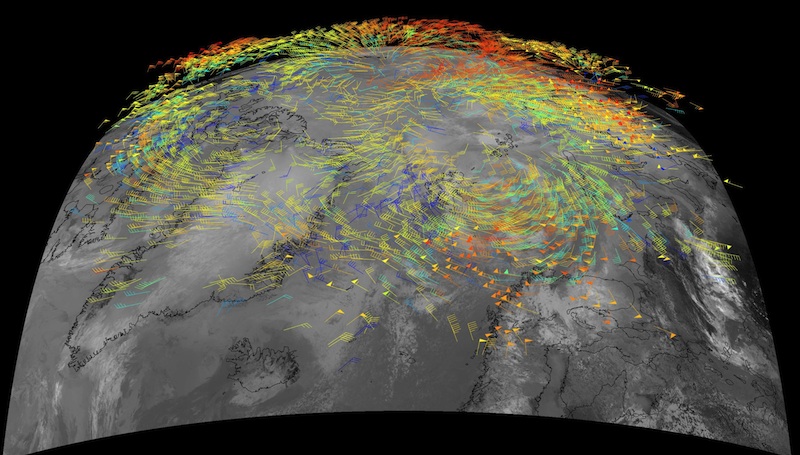
The MODerate-resolution Imaging Spectroradiometer (MODIS) and the Advanced Very High Resolution Radiometer (AVHRR) are being used to generate high-latitude wind fields by tracking cloud and water vapor features in infrared window and water vapor bands. The figure below is a composite of MODIS winds over the Arctic. See the Images page for additional examples.
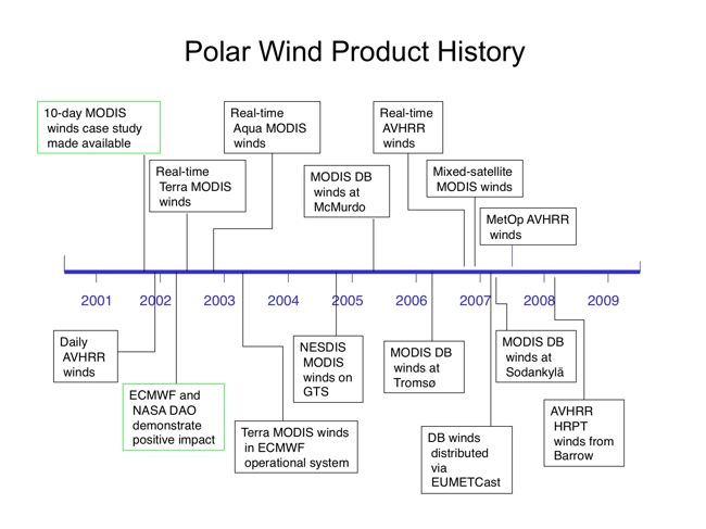
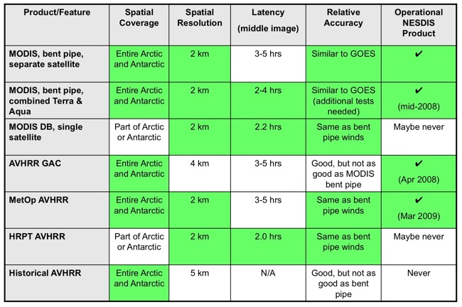
The polar wind product suite has expanded considerably in recent years. In addition to Terra and Aqua MODIS winds being produced separately, a mixed-satellite product was developed in order to improve the timeliness of the winds and to extend the coverage equatorward somewhat. To take advantage of the additional temporal coverage provided by the NOAA satellites, polar wind products from AVHRR on NOAA-15, -16, -17, -18 were implemented. Another AVHRR wind product, currently in an experimental stage, uses AVHRR data from the joint European-U.S. MetOp satellite. Because much of the MODIS and AVHRR wind information is not available soon enough for use in the principle numerical weather prediction data assimilation cycles, MODIS wind processing systems have been implemented at three direct broadcast sites to improve timeliness. Similar to the MODIS direct broadcast winds, winds are being generated from AVHRR data acquired at a High Resolution Picture Transmission (HRPT) site in Barrow, Alaska. Lastly, a polar wind data set spanning more than 20 years was processed using historical AVHRR data for potential use in climate reanalysis projects. Each product has advantages and disadvantages in terms of latency, spatial resolution, and coverage, as well as accuracy.
There is some redundancy in the satellite coverage. NOAA-15 and -16 are in the same orbit separated by about 30 minutes. Metop is about 45 minutes behind NOAA-17. NOAA-18 and Aqua, and NOAA-17 and Terra, are also in similar orbits, separated by 10-30 and 70-90 minutes, respectively.
The main application of the MODIS and AVHRR polar winds are for numerical weather prediction (NWP). See the Impacts page for some early results on how these winds affect numerical weather forecasts. The following NWP centers are using the MODIS winds in their operational systems (13 NWP centers in 9 countries):
Real-time polar wind data are available with conditions. Data access and format is described here as a web page or here as a PDF file. If you're interested in the operational MODIS winds product, we recommend that you get them from NESDIS, as described in the document. Images of near real-time MODIS and AVHRR winds are available here.
AVHRR polar winds are only available in BUFR format via FTP at CIMSS. See the documentation page (link above) for information on contents and file name convention.
The direct broadcast MODIS polar winds are only available via FTP at CIMSS. They are available in BUFR and plain text formats. See the direct broadcast MODIS winds for more information about the direct broadcast sites.
How often can we obtain wind vectors from a polar-orbiting satellite? Not surprisingly, the answer depends on the latitude and the number of satellites. Click here to learn more.
This research is being performed by Jeff Key, Dave Santek, Chris Velden, Jaime Daniels, Nick Bearson, and William Straka III. Scientists at the numerical weather prediction centers have provided invaluable information through testing and model impact studies. The list is long and includes, but is not limited to, Mary Forsythe (Met Office), Lars Peter Riishojgaard (JCSDA), Niels Bormann (ECMWF), Randall Pauley (FNMOC), John LeMarshall (BoM), and Clare Delsol (ECMWF). The idea of a MODIS polar wind product was first suggested by W. Paul Menzel.
This research was supported by the NOAA and NASA.
Key, J., D. Santek, C.S. Velden, N. Bormann, J.-N. Thepaut, L.P. Riishojgaard, Y. Zhu, and W.P. Menzel, 2003, Cloud-drift and Water Vapor Winds in the Polar Regions from MODIS, IEEE Trans. Geosci. Remote Sensing, 41(2), 482-492. PDF version
Bormann, N. and J-N. Thepaut, 2004, Impact of MODIS winds in ECMWF's 4DVAR data assimilation system, Mon. Weather Rev., 132(4), 929-940, DOI: 10.1175/1520-0493(2004)132<0929:IOMPWI>2.0.CO;2.
Le Marshall, J., J. Jung, T. Zapotocny, C. Redder, M. Dunn, J. Daniels, and L.P. Riishojgaard (2008). Impact of MODIS atmospheric motion vectors on a global NWP system. Aust. Met. Mag. 57, 45-51.