[ Archive ]
| CIMSS-NOAA Weekly Report
[ Archive ] |
IN THE PRESS:
ITEMS FOR THE ADMINISTRATOR:
ITEMS FOR THE ASSISTANT ADMINISTRATOR:
ITEMS FOR THE OFFICE DIRECTOR, ORA:
PSDI Proposals Submitted to the Office of Systems
Development: Eight proposals were submitted by the Advanced Satellite
Products Team (ASPT) to the Office of Systems Development (OSD) for consideration
under the Product Systems Development and Implementation (PSDI) process.
The proposed work, which will be done in collaboration with scientists
at the Cooperative Institute for Meteorological Satellite Studies (CIMSS),
includes product development, maintenance, and operational implementation
for geostationary winds, polar winds, Geostationary Operational Environmental
Satellite (GOES) clear sky brightness temperatures, GOES sounder single
field of view radiances and retrievals, GOES imager and sounder clouds,
GOES wildfires, GOES sounder spectral response functions and transmittances,
and intercalibration. The proposed ASPT and CIMSS budgets total approximately
$615K for fiscal year 2003. (J.
Key, E/RA2, 608-263-2605, T.
Schmit, E/RA2, 608-263-0291)
ITEMS FOR THE DIVISION CHIEF, ARAD:
Polar Winds Paper Submitted to Journal: A paper titled "Cloud-drift and Water Vapor Winds in the Polar Regions from MODIS" was submitted to IEEE Transactions on Geoscience and Remote Sensing, a journal of the Institute of Electrical and Electronics Engineers (IEEE), for a special issue on the Aqua satellite. The authors are J. Key (Office of Research and Applications, ORA), D. Santek (Cooperative Institute for Meteorological Satellite Studies, CIMSS), C. Velden (CIMSS), N. Bormann (European Centre for Medium-Range Weather Forecasts, ECMWF), J.-N. Thepaut (ECMWF), L.P. Riishojgaard (Data Assimilation Office, DAO), Y. Zhu (DAO), and W.P. Menzel (ORA). The paper describes how wind information can be obtained from polar-orbiting imagers, specifically the Moderate Resolution Imaging Spectroradiometer (MODIS), and provides results from model impact studies at ECMWF and DAO. (J. Key, E/RA2, 608-263-2605)
Impact of GOES Imager Patch Temperature Change Investigated: On April 29, 2002, engineers at the Satellite Operations Control Center (SOCC) made the annual change of the Geostationary Operational Environmental Satellite (GOES)-8 Imager detector (patch) temperature from the Low to the Mid set point. GOES Imager band 3 (6.7 microns) was most affected, as revealed in a visual inspection of the imagery and in the routine generation of the Clear Sky Brightness Temperature (CSBT) product. For example, the variance within 50 km boxes jumped from approximately 1 to 23 K. While the change only affects the image being acquired when the change is made, it was suggested (to a GOES Engineer) that SOCC consider making future changes during normal data outage periods rather than during image acquisition. (T. Schmit, E/RA2, 608-263-0291, T. Schreiner , CIMSS, 608-263-6754)
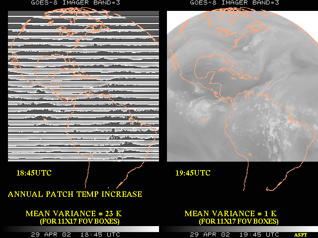
(Click image to enlarge)
Review of Suomi Scholarship Applications: E. Prins assisted Cooperative Institute for Meteorological Satellite Studies (CIMSS) personnel (T. Achtor, L. Avila, T. Whittaker) in reviewing and ranking applications for the Verner E. Suomi Scholarship Award for the 2002/2003 academic year. Over 40 high school seniors applied for the scholarship this year; and the top ten were selected for further consideration by the CIMSS director. The scholarship is open to high school seniors who will be attending a University of Wisconsin System undergraduate program in the physical sciences with an emphasis on those majoring in meteorology, earth science, oceanography, physics, astronomy, science or math education, environmental science and engineering. The winners will be presented with a $1000 scholarship for their freshman year. (E. Prins, E/RA2, 608-263-6607)
VISITORS:
NEXT WEEK:
LOOKING AHEAD:
IN THE PRESS:
ITEMS FOR THE ADMINISTRATOR:
ITEMS FOR THE ASSISTANT ADMINISTRATOR:
ITEMS FOR THE OFFICE DIRECTOR, ORA:
ITEMS FOR THE DIVISION CHIEF, ARAD:
Satellite Images of La Plata, MD Tornado
Added to CIMSS GOES Gallery: The tornado that struck La Plata, Maryland
on April 28, 2002 was the first F5 tornado ever recorded in Maryland. The
imagery on the Cooperative Institute for Meteorological Satellite Studies
(CIMSS) Geostationary Operational Environmental Satellite (GOES) Gallery
from GOES-8 was available at 5-10 minute intervals during this event, as the
satellite was placed into Rapid Scan Operations (RSO) mode earlier in the
day. An "enhanced-V" cloud top signature was evident in the La Plata storm
on the infrared imagery, but not until 23:10 UTC, after the supercell became
tornadic. For images from GOES, the Moderate resolution Imaging Spectroradiometer
(MODIS), and the Advanced Very High Resolution Radiometer (AVHRR) see
http://cimss.ssec.wisc.edu/goes/misc/020428/020428.html.
(S. Bachmeier , CIMSS,
608-263-3958)
VISITORS:
NEXT WEEK:
Winds Workshop in Madison: The 6th International
Winds Workshop will be held in Madison, Wisconsin next week (May 7-10). The
event is co-sponsored by the World Meteorological Organization (WMO), the
Japanese Meteorological Agency (JMA), and the National Environmental Satellite,
Data, and Information Service (NESDIS). C. Velden is the local organiser.
(C. Velden , CIMSS, 608-262-9168)
LOOKING AHEAD: