[ Archive ]

 |
CIMSS-NOAA Weekly Report
[ Archive ] |
 |
IN THE PRESS:
ITEMS FOR THE ADMINISTRATOR:
ITEMS FOR THE ASSISTANT ADMINISTRATOR:
ITEMS FOR THE OFFICE DIRECTOR, ORA:
ITEMS FOR THE DIVISION CHIEF, ARAD:
GOES Sounder Data
for CALJET: Total precipitable water (TPW) and cloud top pressure
(CTP) data from the Geostationary Operational Environmental Satellite (GOES)
Sounder had been requested by P. Nieman (NOAA Environmental Technology Laboratory
(ETL)) for comparison with other data a number of cases from the California
Land-falling Jets Experiment (CALJET). Data from about 40 days, from December
1997 through March 1998, were recovered from tape, re-formatted, displayed,
and posted on a web page for ready access (http://cimss.ssec.wisc.edu/aspt/products/caljet/).
More feedback from ETL is anticipated as they use and evaluate these GOES
TPW and CTP data in their CALJET studies. (G. Wade, E/RA2, 608-263-4743)
Ground Systems Proposals Submitted: Nine proposals were submitted for support from the Ground Systems project. Proposal topics include development for the Geostationary Operational Environmental Satellite (GOES)-9, Clouds from AVHRR (CLAVR) for the METOP system, GOES-12 clear sky brightness temperatures, Arctic composites, the International Advanced TIROS Operational Vertical Sounder (ATOVS) Processing Package, International H2O Project (IHOP) validation, intercalibration, GOES-12 winds, and the GOES Solar Insolation Program (GSIP). (J. Key, E/RA2, 608-263-2605)
Send-off Lunch for
Elaine Prins: The Cooperative Institute for Meteorological Satellite
Studies (CIMSS) said "goodbye" to Elaine Prins with lunch party on Friday,
November 1 at a local Madison restaurant. Approximately 35 colleagues
and friends attended. Ms. Prins will be moving to California next week,
but will continue her work on biomass burning in close collaboration with
CIMSS and Advanced Satellite Products Team (ASPT) scientists.
(J. Key, E/RA2, 608-263-2605,
T. Schmit, E/RA2, 608-263-0291)
Figure caption: Elaine Prins talks with colleagues and friends at her
goodbye lunch (top: Paul Menzel and Kathy Strabala; bottom: Don Wiley). The
party was held at Urban Pizza, Madision, Wisconsin. (Photos by Tim
Schmit.)
NEXT WEEK:
LOOKING AHEAD:
IN THE PRESS:
ITEMS FOR THE ADMINISTRATOR:
ITEMS FOR THE ASSISTANT ADMINISTRATOR:
ITEMS FOR THE OFFICE DIRECTOR, ORA:
ITEMS FOR THE DIVISION CHIEF, ARAD:
Presentations on ABI and HES at SPIE Asia-Pacific
Remote Sensing Symposium: Presentations on the Advanced Baseline Imager
(ABI) and Hyperspectral Environmental (HES) studies were given at the
Society of Photo-optical Instrumentation Engineers (SPIE) Third International
Asia-Pacific Environmental Remote Sensing Symposium held in Hangzhou, China,
October 23-27, 2002. The two presentations are "Advanced Baseline Sounder
(ABS) for future Geostationary Operational Environmental Satellites (GOES-R
and beyond)"authored by J. Li, T. J. Schmit, and W. P. Menzel; and "Advanced
Baseline Imager (ABI) for future Geostationary Operational Environmental
Satellites (GOES-R and beyond)" authored by T. J. Schmit, J. Li, and W. P.
Menzel. The presentations will be published in SPIE proceeding No.
4895 "Applications with Weather Satellites". (J. Li, CIMSS, 608-262-3755, T. Schmit, E/RA2, 608-263-0291)
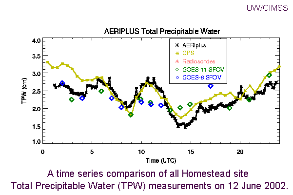
Paper Submitted to Annual AMS Conference: A paper titled "12 June 2002 Rapid Water Vapor Transitions During the IHOP Field Program", by W. Feltz, D. Posselt, J. Mecikalski, G. Wade, and T. Schmit, was submitted for the annual meeting of the American Meteorological Society's (AMS) Symposium on Observing and Understanding the Variability of Water in Weather and Climate. The paper highlights dramatic 1 cm oscillations of total precipitable water (TPW) observed by the Atmospheric Emitted Radiance Interferometer (AERI) and a Global Positioning System (GPS) receiver during the International H20 Program (IHOP) on June 12, 2002 at the IHOP Homestead site in the Oklahoma panhandle. Geostationary Operational Environmental Satellite (GOES)-11 and GOES-8 sounder single field of view (SFOV) TPW were compared to the AERI and GPS measurements showing consistent TPW tendencies until 1100 UTC , indicating skill at resolving these mesoscale water vapor features. The GOES sounder SFOV TPW data smooth through the last water vapor transition, likely due to the relatively large FOV as compared to the tight water vapor gradient detected by the ground based sensors. (W. Feltz, CIMSS, 608-265-6283, G. Wade, E/RA2, 608-263-4743, T. Schmit, E/RA2, 608-263-0291)

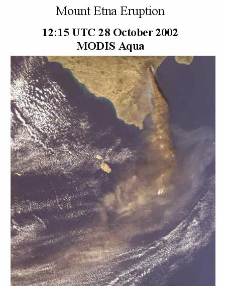
MODIS Views Mt. Etna
Eruption: The Moderate Resolution Imaging Spectroradiometer (MODIS)
instrument on the Aqua satellite provided an excellent view of the Mount
Etna eruption and associated ash plume on October 28, 2002, as shown in the
figure below. (K. Strabala,
CIMSS, 608-263-8752)

PSDI Projects: Eight projects involving geostationary and polar orbiting instruments were approved for funding through the Office of System Development (OSD) Product Systems Development and Implementation (PSDI) project: Geostationary Operational Environmental Satellite (GOES) wildfires, GOES sounder single field of view retrievals, GOES winds, GOES sounder radiative transfer, GOES sounder products, polar winds, satellite intercalibration with both GOES and polar orbiting instruments, and Clouds from AVHRR (CLAVR). (M. Gunshor, CIMSS, 608-263-1146)
VISITORS:
NEXT WEEK:
LOOKING AHEAD: