[ Archive ]
| CIMSS-NOAA Weekly Report
[ Archive ] |
IN THE PRESS:
ITEMS FOR THE ADMINISTRATOR:
ITEMS FOR THE ASSISTANT ADMINISTRATOR:
ITEMS FOR THE OFFICE DIRECTOR, ORA:
Satellite Direct Readout for the Americas Conference: T. Schmit attended the Satellite Direct Readout Users Conference for the Americas conference and spoke on the following topics: data changes on the Geostationary Operational Environmental Satellite (GOES)-12+ Imagers, the Advanced Baseline Imager (ABI), and the Hyperspectral Environmental Suite (HES). The presentations are available upon request. T. Acthor and A. Huang gave presentations on software packages for international users and high spectral resolution data compression. (T. Schmit, E/RA2, 608-263-0291)
ITEMS FOR THE DIVISION CHIEF, ARAD:
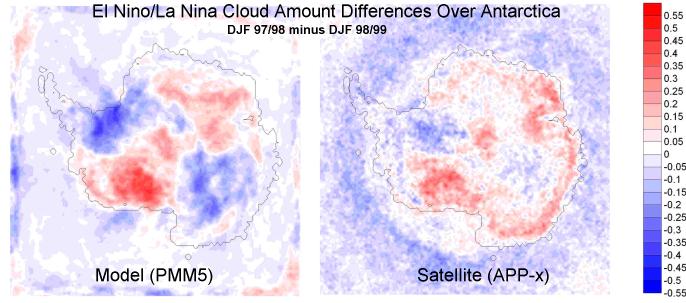
El Niño/La Niña Cloud Differences Over Antarctica: Scientists at the Byrd Polar Research Center of the Ohio Statue University (A. Monaghan and D. Bromwich) found significant differences in modeled cloud amount over Antarctica between the 1997/98 El Niño and the 1998/99 La Niña summers. The cloud amount differences were "verified" with satellite-derived extended Advanced Very High Resolution Radiometer (AVHRR) Polar Pathfinder (APP-x) dataset, developed at the Cooperative Institute for Meteorological Satellite Studies (CIMSS). (J. Key, E/RA2, 608-263-2605)
(Click on image to enlarge)
Figure caption: Comparison of modeled and satellite-derived cloud amount differences between December-January-February 1997/98, an El Niño year, and same months during 1998/99, a La Niña year (1997/98 minus 1998/99) over Antarctica. The image on the left shows cloud amount differences based on the Polar Mesoscale Model 5 (PMM5); the right image shows differences in the extended AVHRR Polar Pathfinder (APP-x) dataset.
Biomass Burning Aerosol Poster Presented at AGU Meeting: T. Eck (Goddard Space Flight Center) presented the poster titled "Inter-annual Variability of Biomass Burning Aerosol Optical Depth in Southern Amazonia, and the Impact of These Aerosols on the Diurnal Cycle of Solar Flux Reduction" at the American Geophysical Union (AGU) Fall meeting in San Francisco. The poster showed that since the early 1990's measurements of aerosol optical depth (AOD) in Amazonia during the dry season display an interannual variability similar to the variability observed in the Geostationary Operational Environmental Satellite (GOES-8) Automated Biomass Burning Algorithm fire pixel counts. The effect of biomass burning aerosols on the solar flux was modeled and revealed significant temporal delays in the solar flux throughout the morning hours resulting in possible delays of the onset of cumulus convection, the shortening of the photo-period when plants photosynthesize, and reduced time interval for UVA (Ultraviolet- A) fluxes which may have implications for photochemical reaction rates, survival of airborne bacteria, insect activity, and plant responses. (E. Prins, E/RA2, 530-271-2256, J. Feltz, CIMSS, 608-263-3434)
Fire Researchers
Meet at AGU Meeting: A group of fire researchers associated
with the Large-Scale Biosphere-Atmosphere Experiment in Amazonia (LBA)
met after the American Geophysical Union (AGU) meeting to discuss
possible areas of collaboration. Multi-satellite fire product
comparisons and ground truth validation was the main focus of the
discussions. Researchers agreed to use existing resources and
work together to obtain a better understanding of the similarities and
differences between the primary satellite fire products for South
America, their accuracy, and how to best fuse the different fire
products. There was also an interest in reprocessing the
Geostationary Operational Environmental Satellite (GOES)-8 half-hourly
imagery from 1994 through 2001 with the Wildfire Automated Biomass
Burning Algorithm (WF_ABBA) to better assess changes in fire activity
and land-use in South America and to extend this interannual analysis
through 2010. (E. Prins,
E/RA2, 530-271-2256)
Polar Meteorology Conference Abstracts Submitted : Four abstracts were submitted for presentation at the American Meteorological Society's Seventh Conference on Polar Meteorology and Oceanography, to be held May 12-16, 2003 in Hyannis, MA. The abstract titles and authors are: "A New View of the Polar Regions from Space (J. Key, invited), "Recent Arctic climate trends observed from space and the cloud-radiation feedback" (X. Wang, Cooperative Institute for Meteorological Satellite Studies (CIMSS) and J. Key), "Study of clear sky, low-level atmospheric temperature inversions using satellite data" (Y. Liu, CIMSS and J. Key), "A 20-year data set of downwelling longwave flux at the Arctic surface from TOVS satellite data" (J. Francis, Rutgers University, A. Schweiger, University of Washington, and J. Key), "Comparison of surface and satellite measurements of Arctic cloud properties" (T. Uttal, Environmental Technology Laboratory, S. Sun-Mack, SAIC, J. Key, and P. Minnis, Langley Research Center). (J. Key, E/RA2, 608-263-2605)
VISITORS:
NEXT WEEK:
LOOKING AHEAD:
IN THE PRESS:
ITEMS FOR THE ADMINISTRATOR:
ITEMS FOR THE ASSISTANT ADMINISTRATOR:
ITEMS FOR THE OFFICE DIRECTOR, ORA:
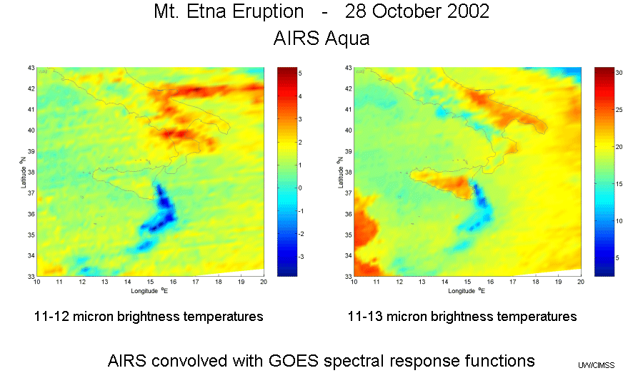
AIRS Used to
Study Volcanic Ash Plume: On October 28, 2002 the Aqua
satellite, carrying the Atmospheric InfraRed Sounder (AIRS), passed over
Mt. Etna (Italy) soon after the volcano had erupted. High spectral
resolution AIRS data was convolved with Geostationary Operational
Environmental Satellite (GOES) Imager spectral response functions for
the 11 and 12 micron bands on GOES-8 and the 13 micron band on
GOES-12. Images made from the 11-12 micron and 11-13 micron
brightness temperature differences clearly show the volcanic ash plume.
(M. Gunshor, CIMSS,
608-263-1146)
(Click on image to enlarge)
ITEMS FOR THE DIVISION CHIEF, ARAD:
Presentation at
Canadian Winter Weather Forecasting Course: S. Bachmeier gave a
presentation "An Overview of Water Vapor Imagery" at the Meteorological
Service of Canada (MSC)/Cooperative Program for Operational
Meteorological Education and Training (COMET) Winter Weather Forecasting
Course on December 12, 2002 at COMET in Boulder, Colorado. Examples of
water vapor imagery were shown using data from both Geostationary
Operational Environmental Satellite (GOES, including the new GOES-12)
and Moderate-Resolution Imaging Spectroradiometer (MODIS) to illustrate
applications over the high latitudes of Canada and Alaska.
Representatives from all five MSC Regions, Aviation and Defense
Services, and the Canadian Meteorological Center were present at the
course, along with forecasters from the Alaska Region of the National
Weather Service.( S.
Bachmeier, CIMSS, 608-263-3958)
Joint Typhoon Warning Center Visit: C. Velden visited the Joint Typhoon Warning Center (JTWC) to discuss collaborative research projects with both forecasters and satellite analysts. JTWC supplied various tropical cyclone forecast desirements in terms of satellite products, and applauded CIMSS efforts in the area of recent advancements (e.g., the Advanced Microwave Sounding Unit (AMSU), Advanced Objective Dvorak Technique (AODT), shear products). (C. Velden, CIMSS, 608-262-9168)
WMO Tropical Cyclone Forecast Office Directors Meet: C. Velden attended a meeting of the directors from World Meteorological Organization Regional Tropical Cyclone Forecast Offices. Issues regarding typhoon forecasting procedures and advances were discussed. Velden provided the latest information on current/projected satellite coverage (e.g., Geostationary Operational Environmental Satellite (GOES)-9 replacement of the Geostationary Meteorological Satellite (GMS), Meteosat Second Generation (MSG), Multifunctional Transport Satellite (MTSAT)) as well as emerging new products/technologies such as the Advanced Microwave Sounding Unit (AMSU) and the Geostationary Imaging Fourier Transform Spectrometer (GIFTS). (C. Velden, CIMSS, 608-262-9168)
International Workshop on Tropcial Cyclones: The 5th International Workshop on Tropical Cyclones (IWTC-V) was recently held in Cairns Australia. Attendees included C. Velden and J. Kossin from the Cooperative Institute for Meteorological Satellite Studies (CIMSS). C. Velden was the organizer of the keynote session on satellite tropical cyclone applications and the future scenario. Special tutorial sessions were given on the Advanced Microwave Sounding Unit (AMSU), the Advanced Objective Dvorak Technique (AODT) ,and Quikscat datasets. There was considerable interest in these new products from the attendees, which represented a mix of forecasters and researchers from around the world. (C. Velden, CIMSS, 608-262-9168)
Intercalibration
Paper Submitted: A paper titled "Intercalibration of the infrared
window and water vapor channels on operational geostationary
environmental satellites using a single polar orbiting satellite" has
been submitted to the Journal of
Atmospheric and Oceanic Technology. The paper outlines the
results and methodology used at the Cooperative Institute for
Meteorological Satellite Studies (CIMSS) to inter-compare geostationary
instruments with the National Oceanic and Atmospheric Administration
(NOAA)-14 High-resolution Infrared Radiation Sounder (HIRS) and Advanced
Very High Resolution Radiometer (AVHRR). The study includes
Geostationary Operational Environmental Satellite (GOES) -8, -10,
METEOrological SATellite (Meteosat)-5, -7, and Geostationary
Meteorological Satellite (GMS)-5.
(M. Gunshor, CIMSS,
608-263-1146, T. Schmit,
E/RA2, 608-263-0291, W.P. Menzel, E/RA2, 608-263-4930)
VISITORS:
NEXT WEEK:
LOOKING AHEAD: