[ Archive ]
| CIMSS-NOAA Weekly Report
[ Archive ] |
IN THE PRESS:
ITEMS FOR THE ADMINISTRATOR:
ITEMS FOR THE ASSISTANT ADMINISTRATOR:
ITEMS FOR THE OFFICE DIRECTOR, ORA:
GOES-12 Intercalibration at CIMSS: The Cooperative Institute for Meteorological Satellite Studies (CIMSS) has begun routine intercalibration using the Geostationary Operational Environmental Satellite (GOES) -12 as the operational GOES-East. The transition from GOES-8 occurred as GOES-12 became the operational instrument on April 1, 2003. Preliminary results show favorable comparisons between GOES-12 and National Oceanic and Atmospheric Administration (NOAA)-15 High-resolution Infrared Radiation Sounder (HIRS) and Advanced Very High Resolution Radiometer (AVHRR) in the Infrared Window and Water Vapor Channels. (M. Gunshor, CIMSS, 608-263-1146)
Florida Division of Emergency Management Requests GOES-12 WF_ABBA Fire Product: G. Watry of the Florida Division of Emergency Management Office of Policy and Planning inquired about the possibility of implementing the Geostationary Operational Environmental Satellite (GOES)-12 Wildfire Automated Biomass Burning Algorithm (WF_ABBA) within their Geographic Information System (GIS). As this possibility is being evaluated, the Florida Division of Emergency Management will initially access GOES-12 WF_ABBA fire products via anonymous ftp (file transfer protocol) at the Cooperative Institute for Meteorological Satellite Studies (CIMSS). ASCII fire product files for North America are currently available on the CIMSS ftp site within 30-45 minutes of the GOES image time. The WF_ABBA ASCII files will be integrated into the Florida Emergency Management GIS in near real-time. (E. Prins, E/RA2, 530-271-2256, C. Schmidt, CIMSS, 608-262-7973)
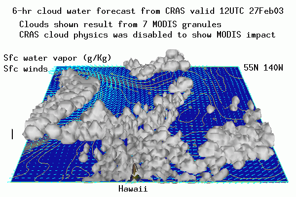
ITEMS FOR THE DIVISION CHIEF, ARAD:MODIS Cloud Assimilation Testing at CIMSS:
Cloud-top pressure and effective cloud amount retrievals from the
MOderate Resolution Imaging Spectrometer (MODIS) are being evaluated
for cloud water initialization over the Pacific region using the CIMSS
Regional Assimilation System (CRAS) at the Cooperative Institute for
Meteorological Studies (CIMSS). Further evaluation will be
conducted to determine if the MODIS data can be used simultaneously
with cloud retrievals from the GOES sounders. (R. Aune, E/RA2, 608-262-1071)
 (Click
image to enlarge)
(Click
image to enlarge)
Figure caption: The 3-dimensional cloud water, surface mixing ratio
(g/Kg) and surface winds at the end of a 6-hour CRAS forecast cycle
that incorporated cloud information from seven 5-minute MODIS granules.
The clouds shown result from MODIS information only as the cloud physics
in the CRAS was disabled during this test.
BUFR Display Addition: A new routine was
written and tested for the Binary Universial Form for data
Repressentation (BUFR) display program. BUFR is a storage and
transmission format for meteorological observations. Before the
visualization routine could display the contents of a selected
observation (record); now it can also display a selected variable, such
as latitude, for all the observations in a file. (G. Callan, E/RA2,
608-263-3951)
Elementary School Presentation on the Arctic:
J. Key gave a presentation on the Arctic to three 3rd grade classes,
approximately 70 students, at Sunset Ridge Elementary School in
Middleton, Wisconsin. The interactive presentation covered
differences between the Arctic and Antarctic, snow and ice
characteristics, indigenous people, scientific field experiments, and,
of course, animals. (J. Key,
E/RA2, 608-263-2605)