[ Archive ]
| CIMSS-NOAA Weekly Report
[ Archive ] |
IN THE PRESS:
ITEMS FOR THE ADMINISTRATOR:
ITEMS FOR THE ASSISTANT ADMINISTRATOR:
ITEMS FOR THE OFFICE DIRECTOR, ORA:
"Introducing GOES-12" VISIT Distance Learning Lesson: The new "Introducing Geostationary Operational Environmental Satellite (GOES-12)" Virtual Institute for Satellite Integration Training (VISIT) lesson was given for the first time on 11 April 2003. Eight National Weather Service (NWS) offices participated in the distance learning lesson, with forty NWS staff in attendance. (S. Bachmeier, CIMSS, 608-263-3958)
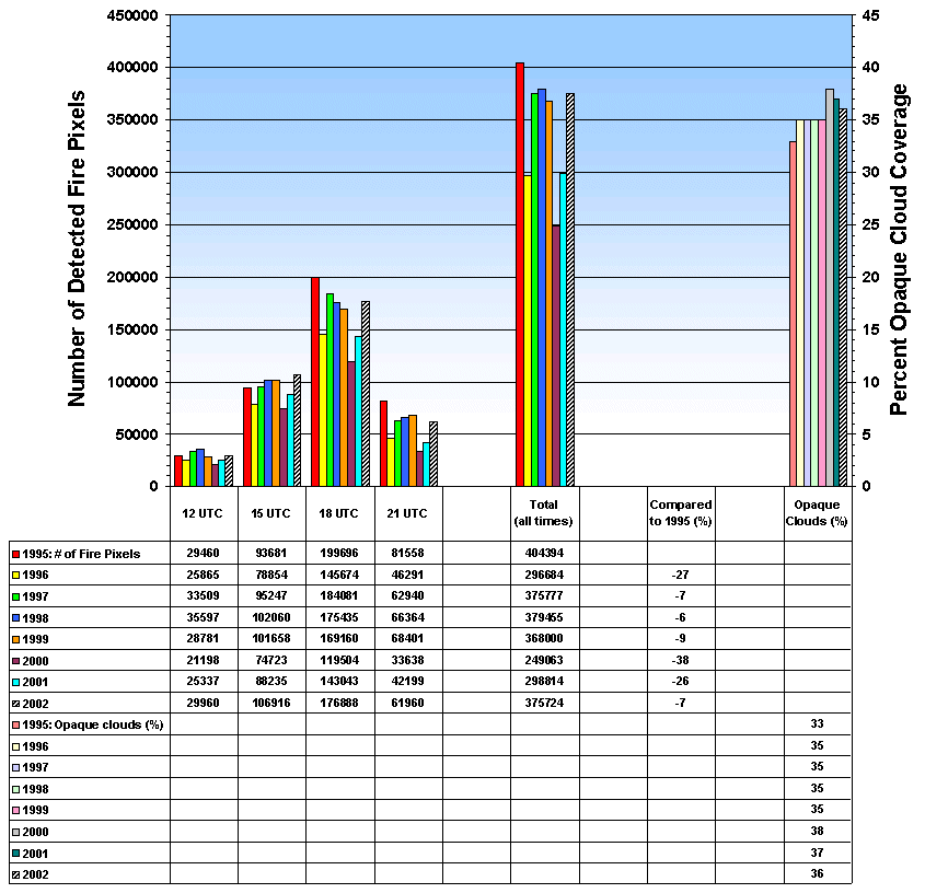
Biomass Burning Trend Analysis in South America:
Geostationary Operational Environmental Satellite (GOES)-8 Automated
Biomass Burning Algorithm (ABBA) fire products for June through October
2002 indicate that the amount of burning during the 2002 fire season in
South America was over 25% higher than observed in 2001 and 50% higher
than 2000. Much of this fire activity occurred late in the fire
season with over 375,000 fire pixels detected by the GOES-8 ABBA at
11:45, 14:45, 17:45, and 20:45 UTC. These results are being
integrated into an 8-year GOES-8 fire, smoke, and cloud climatology to
characterize diurnal, spatial, seasonal and interannual trends in South
America. The study area extends from 0 to 40°S and from 35 to
75°W and includes portions of Brazil, Peru, Bolivia, Paraguay,
Uruguay, and northern Argentina. (E. Prins, E/RA2,
608-263-6607, J. Feltz, CIMSS, 608-263-3434)
 (Click on
image to enlarge)
(Click on
image to enlarge)
Figure caption: The GOES-8 ABBA and Merged Automated Cloud/Aerosol
Detection Algorithm (MACADA) were applied to 3-hourly (11:45, 14:45,
17:45, and 20:45 UTC) multispectral data collected from June through
October in each year from 1995 to 2002. The figure gives an
overview of the number of fire pixels detected at each time period and
total burning for each year, along with the percent opaque cloud
coverage. The number of fires detected in the 2002 fire season
represents a large increase in burning observed over the previous two
years. The opaque cloud coverage gives an indication if the interannual
variability in the number of detected fire pixels is due to cloud
coverage issues.
 (Click on image to enlarge)
 (Click on image to enlarge)
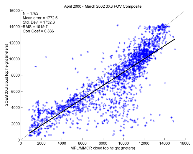
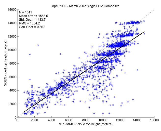
Figure caption: The two figures compare the GOES cloud top pressure
(CTP) with the micropulse lidar/millimeter cloud radar (MPL/MMCR) for
the 3x3 GOES product (top) and the GOES single field-of-view (SFOV,
bottom). The SFOV product compares as favorably with the MPL/MMCR
product as the 3x3 GOES product. The tendency for the GOES to
have lower cloud tops than the MPL/MMCR is consistent with the physics
of the two measurements.
ITEMS FOR THE DIVISION CHIEF, ARAD:
AVN Now Used as Temperature/Moisture Retrieval First Guess: The Geostationary Operational Environmental Sounder (GOES) Sounder retrieved profiles and associated Derived Product Imagery (DPI) generated at the Cooperative Institute for Meteorological Satellite Studies (CIMSS), at 3x3 field-of-view (FOV) horizontal resolution, are now using forecast fields from the National Centers for Environmental Prediction (NCEP) Aviation (AVN) model as the first guess. Previously, the NCEP Eta model was used. Now both the 3x3 1x1 FOV retrievals use the AVN model as the first guess (http://cimss.ssec.wisc.edu/goes/realtime/changes.html). (J. Nelson, CIMSS, 608-263-6013)
VISITORS: