 |
ASPB and CIMSS Weekly Report
[ Archive ] |
 |
ASPB AND CIMSS WEEKLY HIGHLIGHTS FOR THE WEEK ENDING AUGUST 4, 2007
IN THE PRESS:
ITEMS FOR THE ADMINISTRATOR:
ITEMS FOR THE ASSISTANT ADMINISTRATOR:
ITEMS FOR THE OFFICE DIRECTOR, STAR:
GEO User Interface Committee Meeting: The
Group on Earth Observations (GEO) User Interface Committee (UIC) held a
meeting in Washington, D.C. August 1-3, 2007. The UIC engages users in
the nine GEO societal benefit areas in the development, implementation,
and use of a sustained GEOSS (Global Earth Observation System of
Systems) that provides the data and information required by user groups
on national, regional, and global scales. The objectives of the meeting
were to discuss the GEO Work Plan for 2008, the migration of the
Integrated Global Observing Strategy (IGOS) themes into GEO, the
upcoming GEO Ministerial Summit (Cape Town, South Africa, November
2007), and the GEO Portal. Breakout sessions were held for a subset of
the GEO Societal Benefit Areas. J. Key attended the meeting and gave a
presentation on the status of the IGOS Cryosphere Theme (http://igos-cryosphere.org) and plans for the development of a GEO Cryosphere Community of Practice.
(J. Key, E/RA2, 608-263-2605, jkey@ssec.wisc.edu)
ITEMS FOR THE DIVISION CHIEF, CoRP:
Improved Image Navigation and Registration on GOES-13 Satellite: Two
recent comparisons of Geostationary Operational Environmental Satellite
(GOES-13) and GOES-12 images posted on the Cooperative Institute for
Meteorological Satellite Studies (CIMSS) Satellite Blog (http://cimss.ssec.wisc.edu/goes/blog/category/goes-13)
demonstrate obvious improvements in the image navigation and
registration (INR) system on the GOES-13 satellite. Once case shows
visible and shortwave InfraRed (IR) imagery of a wildfire burning in
the Upper Peninsula of Michigan on August 3, 2007, while another case
shows ice floes drifting in Hudson Bay, Canada on July 30, 2007. In the
case of the ice floes in Hudson Bay, the improved GOES-13 INR allowed
more accurate tracking of the speed and direction of the ice features
that were being transported by relatively fast-moving cold water
eddies. (S. Bachmeier, CIMSS, 608-263-3958)
GOES-13 CSBT Data Produced in Real Time: As part of the Geostationary Operational Environmental Satellite (GOES) -13 demonstration, GOES Imager data are now temporarily available in real time. This satellite processing schedule for GOES-13 is expected to continue until the middle of August (2007). Consequently three-hourly Binary Universal FoRm (BUFR) files of hemispheric Clear Sky Brightness Temperature (CSBT) data are being routinely generated. The purpose of this exercise is twofold: (1) it is a way to determine whether the BUFR files are readable, and (2) to ascertain the quality of the clear observations. (T. Schreiner, CIMSS, 608-263-6754, T. Schmit, E/RA2, 608-263-0291, tim.j.schmit@noaa.gov, T. Olander, CIMSS, 608-265-8005, T. Olander, CIMSS, 608-265-8005)
More MODIS Imagery Added to AWIPS: On August 3, 2007, the Cooperative Institute for Meteorological Satellite Studies (CIMSS) expanded the amount of Moderate Resolution Imaging Spectroradiometer (MODIS) imagery currently provided to the National Weather Service (NWS) in Sullivan, Wisconsin. J. Gerth spent the day at the NWS in Sullivan, assisting office technical staff with the installation of MODIS true color imagery at 250m resolution. To deliver the imagery with more than 255 colors, the implementation of a new compact software tool developed by Gerth to supplement the Advanced Weather Interactive Processing System (AWIPS) was required. After a short introduction and presentation, forecasters remarked that the new true color imagery would be useful in determining areas of damage following destructive weather. CIMSS continues a strong working relationship with the NWS in Sullivan to support NWS forecast operations with innovative satellite imagery and products across the United States. (J. Gerth, CIMSS, 608-263-4942)
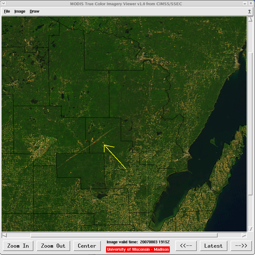 (Click image to enlarge)
Figure caption: This compact tool supplements AWIPS, and allows for basic image manipulations, such as centering and zooming.
Abstracts submitted to the GOES User’s Conference: T.
Schmit submitted two abstracts to the Fifth Geostationary Operational
Environmental Satellite (GOES) User’s Conference. The titles are “The
ABI (Advanced Baseline Imager) on the GOES-R series” and “GOES-10 @ 60
West – A Wisconsin Perspective”. The abstract deadline is now August
24th. The conference is January 23-24, 2008. (T. Schmit, E/RA2,
608-263-0291, tim.j.schmit@noaa.gov)
Other Meetings and Telecons:
None.
VISITORS:
NEXT WEEK:
LOOKING AHEAD: