
[ Archive ]

|
ASPB and CIMSS Weekly Report
[ Archive ] |
|
IN THE PRESS:
ITEMS FOR THE ADMINISTRATOR:
ITEMS FOR THE ASSISTANT ADMINISTRATOR:
ITEMS FOR THE OFFICE DIRECTOR, STAR:
Ninth International Winds Workshop: The Ninth International Winds Workshop (IWW) was held at the Historic Inns of Annapolis, Annapolis, MD, April 14-18. The IWWs are an ideal forum for interacting with the numerical weather prediction (NWP) community on product developments, forecast impacts, and problems. Scientists from the international satellite and numerical weather prediction communities participated in the workshop, with representatives from (but not limited to) the U.S., the U.K., France, Germany, Spain, Japan, Korea, China, Australia, New Zealand, and India. Chris Velden (Cooperative Institute for Meteorological Satellite Studies) is the co-chair of the Working Group on Satellite-Derived Winds. Jaime Daniels (STAR) was one of the workshop organizers. (J. Key, E/RA2, 608-263-2605, jeff.key@noaa.gov, C. Velden, CIMSS, 608-262-9168)
CIMSS AIRS/MODIS LST Comparison Reported at NCDC Workshop: The
Cooperative Institute for Meteorological Satellite Studies (CIMSS)
reported on a comparison of land surface temperature (LST) products
produced by the NASA Atmospheric InfraRed Sounder (AIRS) and the
Moderate Resolution Imaging Spectroradiometer (MODIS) at a workshop
hosted by the National Climate Data Center (NCDC) April 7-9, 2008 (http://www.joss.ucar.edu/joss_psg/meetings/Meetings_2008/Bridging_the_Gaps/index.html).
The comparison of monthly mean clear-sky LST between the imager and
sounder was shown to be a valuable metric for the evaluation of future
LST climate products. The presentation authors are Robert O. Knuteson,
S. Ackerman, H.E. Revercomb, and D.C.
Tobin. The title is "Comparison of NASA AIRS and MODIS Land Surface
Temperature and Infrared Emissivity Measurements from the EOS AQUA
platform". (R. Knuteson, SSEC/CIMSS, 608-263-7974, S. Ackerman, CIMSS,
608-263-3647, H. Revercomb, SSEC/CIMSS, 608-263-6758, D. Tobin,
SSEC/CIMSS, 608-265-6281)
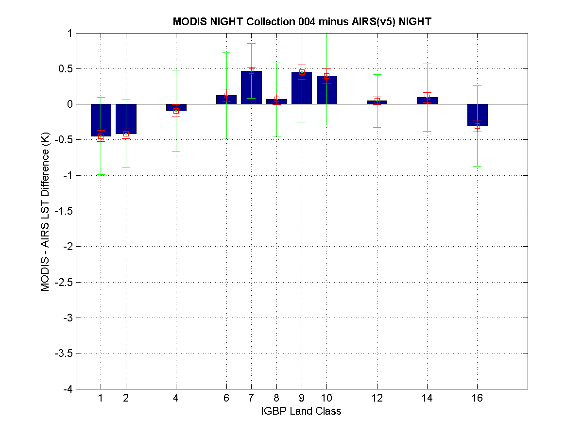 (Click image to enlarge)
Figure
caption: The mean bias is less than 0.5 K between MODIS (Collection 4)
and AIRS (Version 5) nighttime clear-sky land surface temperatures
(LSTs) for the four year period (2003-2006) excluding snow/ice scenes.
The LST temperature bias is shown by land cover type using the
International Geosphere Biosphere Program (IGBP) classification. The
green error bars represent the standard deviation within a class. The
red error bars are an estimate of the uncertainty in the mean. Larger
differences than those shown here were seen in the daytime comparison
for MODIS Collection 4.
COMAP Course Satellite Applications Lecture and Lab: S.
Bachmeier (Cooperative Institute for Meteorological Satellite Studies, CIMSS) participated as an instructor on Day 4 (April 17, 2008) of
the 15-day Cooperative Program for Operational Meteorology, Education,
and Training (COMET) Mesoscale Analysis and Prediction Course (COMAP)
residence course for National Weather Service (NWS) Science and
Operations Officers (SOOs) held at Boulder, Colorado. A half-day
lecture and lab session "Satellite Applications: Dynamic Feature
Identification" was given, which discussed the use of Geostationary
Operational Environmental Satellite (GOES) and Moderate resolution
Imaging Spectroradiometer (MODIS) water vapor channel imagery along
with the GOES sounder Total Column Ozone product to diagnose important
upper tropospheric dynamical structures such as potential vorticity
anomalies and the dynamic tropopause. The utility of Cooperative
Institute for Meteorological Satellite Studies (CIMSS) Regional
Assimilation System (CRAS) model forecast water vapor channel satellite
imagery products for dynamic feature identification was also
demonstrated as part of the lecture. (S. Bachmeier, CIMSS,
608-263-3958)
ITEMS FOR THE DIVISION CHIEF, CoRP:
Education Collaboration: In preparation for the upcoming cooperative institute (CI) directors meeting, Steve Ackerman and Paul Menzel participated in a teleconference that was held to discuss the lessons learned from our education collaboration on virtual classroom visits in Fall 2007. The intent of this collaboration is two fold: 1) to support community building between the CI through education collaborations and 2) to leverage appropriate learning technologies to support education activities across the institutes. In general the VISITView (Virtual Institute for Satellite Integration Training) technology worked fine. After sharing experiences, suggestions for the next collaboration include: 1) Instructor meets with students prior to lecture. 2) Instructor meets with students after lecture (e.g. at CI Symposium). 3) Keep lesson short and include more activity for students. 4) Send preparatory material ahead of time and use the virtual lecture to answer questions or guide analysis/interpretation. 5) Have each student use their own computer rather than one computer for entire class. 6) Incorporate quizzing into the virtual lecture. We are proposing to continue this collaboration experiment in Fall 2008, but will confirm this at the CI directors meeting in June. Presentations will be archived on CoRP web page. (S. Ackerman, CIMSS, 608-263-3647)SO2 Plumes from the Kilauea Volcano in Hawaii as Seen from Space: Explosive events from the Kilauea Volcano (located on the Big Island of Hawaii) began to occur in mid-March of 2008. These were the first explosive events from that particular volcano since 1927. Activity from Kilauea then continued for several weeks; visible imagery from 07-08 April 2008 showed the hazy signature of a long volcanic plume (composed primarily of steam, but possibly containing small amounts of ash) streaming from Hawaii. Infrared measurements from both Geostationary Operational Environmental Satellite (GOES) sounder and the MODerate-resolution Imaging Spectroradiometer (MODIS) also capture the sulfur dioxide (SO2) plume. The MODIS difference using the 8.5 minus 11 micron bands showcase what will be able to be done at a finer temporal resolution with the Advanced Baseline Imager (ABI) on GOES-R. It can be seen here on the CIMSS Satellite Blog: http://cimss.ssec.wisc.edu/goes/blog/archives/638. (M. Gunshor, CIMSS, 608-263-1146, S. Bachmeier, CIMSS, T. Schmit, E/RA2, 608-263-0291, tim.j.schmit@noaa.gov)
GOES-10 Manuscript Submitted: A manuscript on
the Geostationary Operational Environmental Satellite (GOES)-10 was
submitted to the International Society for Optical Engineering (SPIE)’s
Journal of Applied Remote Sensing. Since its retirement, GOES-10
has been used for a number of applications, such as special 1-minute
imagery over parts of North America during its move to 60 degree West
longitude, routine imagery of the Southern Hemisphere, the first
operational Sounder coverage over South America, initialization of
regional numerical weather prediction models, and even temporary recall
as the operational GOES-East satellite during a major GOES-12 anomaly.
The manuscript title is: “Many Uses of the GOES-10 Sounder and Imager
during a High Inclination State”. The authors are T. Schmit, R. Rabin,
A. S. Bachmeier, J. Li, M. M. Gunshor, H. Steigerwaldt, A. J.
Schreiner, R. Aune and G. S. Wade. (T. Schmit, E/RA2, 608-263-0291,
tim.j.schmit@noaa.gov)
Other Meetings and Telecons:
None.
VISITORS:
NEXT WEEK:
LOOKING AHEAD:
| Archived Weeklies Page | Submit a report item |