
[ Archive ]

|
ASPB and CIMSS Weekly Report
[ Archive ] |
|
IN THE PRESS:
ITEMS FOR THE ADMINISTRATOR:
ITEMS FOR THE ASSISTANT ADMINISTRATOR:
ITEMS FOR THE OFFICE DIRECTOR, STAR:
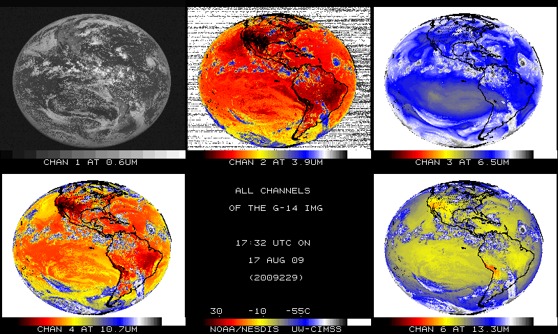
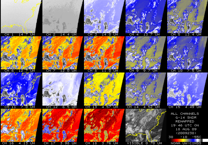
First GOES-14 Imager and Sounder Infrared Images: The
first Geostationary Operational Environmental Satellite (GOES-14)
Imager and Sounder infrared (IR) data were scanned and ingested on
August 17 and 18. A qualitative look shows better noise performance of
the GOES-14 IR data compared to GOES-12. More information can be found at http://www.star.nesdis.noaa.gov/star, http://www.ssec.wisc.edu/media/spotlight/goes14/ir.html, http://cimss.ssec.wisc.edu/goes/blog/archives/category/goes-14, and http://rammb.cira.colostate.edu/projects/goes-o. (T. Schmit, E/RA2, 608-263-0291, tim.j.schmit@noaa.gov; SSEC Data Center)(T. Schmit, E/RA2,
608-263-0291, tim.j.schmit@noaa.gov; SSEC Data Center)
 (Click image to enlarge)
Figure caption: First multi-band image generated from the GOES-14 Imager on August 17, 2009.
 (Click image to enlarge)
Figure caption: First multi-band image generated from the GOES-14 Sounder on August 18, 2009.
Presentations at High Latitude and Arctic Proving Ground Meeting: S.
Bachmeier (Cooperative Institute for Meteorological Satellite Studies,
CIMSS), J. Gerth (CIMSS), and M. Pavolonis (NOAA/NESDIS) all presented
at the High Latitude and Arctic Proving Ground Meeting held in
Fairbanks and Anchorage, Alaska, August 18 - 20. The presentations
covered CIMSS Proving Ground activities with the National Weather
Service (NWS), efforts to improve Advanced Very High Resolution
Radiometer (AVHRR) products, and automated volcanic ash detection
capabilities. (M. Pavolonis, E/RA2, 608-263-9597,
Mike.Pavolonis@noaa.gov, S. Bachmeier, CIMSS, 608-263-3958, J. Gerth,
CIMSS)
ITEMS FOR THE DIVISION CHIEF, CoRP:
CIMSS Tropical Cyclone Group Releases On-line Archive: The Cooperative Institute for Meteorological Satellite Studies (CIMSS) Tropical Cyclone group has made available nearly ten years of its specialized tropical cyclone products. The products are accessible on line at http://tropic.ssec.wisc.edu/archive. Key support for this development was provided by NOAA/NESDIS STAR GOES Improved Measurements and Product Assurance Plan (GIMPAP). (C. Velden, CIMSS,608-262-9168, D. Stettner, CIMSS, 608-262-8850)
Workshop on Multisensor Measurement of Precipitation: R. Aune attended the Multisensor Measurement of Precipitation Workshop hosted by the Department of Engineering, University of Wisconsin. The workshop, sponsored by the University of Wisconsin Extention and NOAA, focused on how precipitation observations from the National Weather Service Next-generation weather Radar (NEXRAD) can be bias corrected with in situ rain gauge measurements and used to manage regional water resources in Wisconsin. R. Aune reported on the current and future state of precipitation measurements using spaced-based instruments. A summary of the GOES sounder near-casting model under development at the Cooperative Institute for Meteorological Satellite Studies (CIMSS) was presented, with an emphasis on how it could be used to predict significant flooding events. (R. Aune, E/RA2, 608-262-1071) (Click image to enlarge)
PATMOS-x Data Provided for Samoan Coral Bleaching Study: Andrew
Heidinger provided a 31-year high-resolution time series of climate
products from the NESDIS Advanced Very High Resolution Radiometer
(AVHRR) Pathfinder Extended (PATMOS-x) data-set to Doug Pirhalla of the
NOAA National Ocean Service to aid in a study of coral bleaching around
the Samoan Islands. The PATMOS-x products from the NOAA AVHRR provide
four views per day and offer information on the radiative fluxes at the
ocean's surface and the amount and severity of coral bleaching. (A.
Heidinger, E/RA2, 608-263-6757, andrew.heidinger@noaa.gov)
VISITORS:
NEXT WEEK:
LOOKING AHEAD:
| Archived Weeklies Page | Submit a report item |