
[ Archive ]

|
ASPB and CIMSS Weekly Report
[ Archive ] |
|
IN THE PRESS:
Mecca of Satellite Meteorology: The Wisconsin State Journal, a major Wisconsin newspaper, recently published an article on the Cooperative Institute for Meteorological Satellite Studies (CIMSS) titled "Using cutting-edge technology, UW leads the way in weather forecasting" (http://host.madison.com/wsj/news/science/using-cutting-edge-technology-uw-leads-the-way-in-weather/article_438a2450-161a-11e1-9497-001cc4c002e0.html). The article describes some of the research done at CIMSS and the importance of satellite data in weather forecasting. (J. Key, E/RA2, 608-263-2605, jkey@ssec.wisc.edu)
ITEMS FOR THE ADMINISTRATOR:
ITEMS FOR THE ASSISTANT ADMINISTRATOR:
ITEMS FOR THE OFFICE DIRECTOR, STAR:
GOES-15 Becomes Operational: At 15:45 UTC on
06 December 2011, Geostationary Operational Environmental Satellite
(GOES)-15 replaced GOES-11 as the operational GOES-West satellite.
GOES-11 (launched in 2000, and operational since 2006) was one of the
older GOES-I/M series of satellites. Compared to GOES-11, GOES-15 has:
(1) improved water vapor channel (Imager channel 3); (2) slightly
different visible channel (Imager channel 1); (3) 13.3 µm IR (Imager
channel 6) replaces the 12.0 µm IR (Imager channel 5) and (4) improved
Image Navigation and Registration (INR). Examples of some of these
GOES-11 vs GOES-15 changes before and after the switch-over can be found
at http://cimss.ssec.wisc.edu/goes/blog/archives/9307. Material was
also supplied for a "GOES-15 Becomes GOES-West" training session for
National Weather Service (NWS)forecast offices
(http://rammb.cira.colostate.edu/training/visit/training_sessions/goes-15_becomes_goes-west/),
and T. Schmit and S. Bachmeier participated in the first training
lessons that were offered during the week of the satellite transition.
(S. Bachmeier, CIMSS, 608-263-3958; J. Gerth, CIMSS, 608-263-4942; A.
Schreiner, CIMSS, 608=263-6754; T. Schmit, E/RA2, 608-263-0291,
tim.j.schmit@noaa.gov)
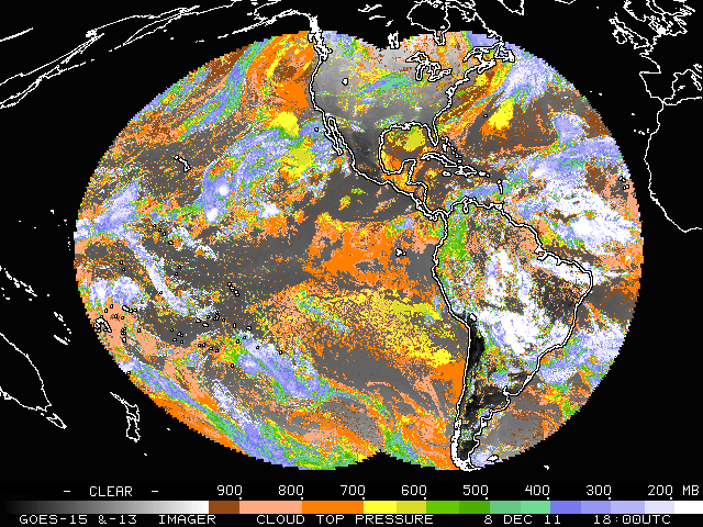 (Click image to enlarge)
Figure caption: With the operational insertion of GOES-15 (and the
inclusion of the 13.3 um micron band) as the western geostationary
satellite, both GOES-East and GOES-West Imagers are capable of generating
cloud top pressures for both opaque and semi-transparent clouds using
the same algorithm.
ITEMS FOR THE DIVISION CHIEF, CoRP:
Release of Radiative Transfer Model Coefficient Files from CIMSS: In early November 2011, the latest version of the Pressure-Layer Optical Depth (PLOD)/Pressure layer Fast Algorithm for Atmospheric Transmittances (PFAAST) Radiative Transfer Model (RTM) coefficient files was made available to scientists at NOAA/NESDIS by scientists at the Cooperative Institute for Meteorological Satellite Studies (CIMSS). The files make use of the latest available Spectral Response Functions (SRF) for Geostationary Operational Environmental Satellite (GOES)-14 and -15 Imager bands 3 (6.7um) and 6 (13.3um), and also include updated GOES Sounder noise vectors for GOES-13, -14 and -15. The information contained in these files is required for computation of atmospheric transmittances, which in turn is essential for GOES processing including retrievals of vertical profiles of atmospheric moisture and temperature, as well as various cloud properties. (J. Nelson, CIMSS, 608-263-6013; S. Moeller, CIMSS, 608-263-1976; M. Gunshor, CIMSS, 608-263-1146; T. Schreiner, CIMSS, 608-263-6754; T. J. Schmit, E/RA2, 608-263-0291, tim.j.schmit@noaa.gov; G. S. Wade, E/RA2, 608-263-4743, gary.s.wade@noaa.gov)VISITORS:
NEXT WEEK:
LOOKING AHEAD:
| Archived Weeklies Page | Submit a report item |