[ Archive ]
| CIMSS-NOAA Weekly Report [ Archive ] |
ASPB AND CIMSS WEEKLY HIGHLIGHTS FOR THE WEEK ENDING MARCH 9, 2018
IN THE PRESS:
ITEMS FOR THE ADMINISTRATOR:
ITEMS FOR THE ASSISTANT ADMINISTRATOR:
ITEMS FOR THE OFFICE DIRECTOR, STAR:
Paper on Improved Severe Weather Forecasting Published: A paper, titled “The NOAA/CIMSS ProbSevere Model: Incorporation of Total Lightning and Validation,” has been published in the American Meteorological Society (AMS) Weather and Forecasting journal. The authors are: J. Cintineo, M. Pavolonis (NOAA/NESDIS/STAR), J. Sieglaff, D. Lindsey, L. Cronce, J. Gerth, B. Rodenkirch, J. Brunner, and C. Gravelle. The paper describes how ground-based measurements of lightning, from Earth Networks, were incorporated into the Probability of Severe (ProbSevere) statistical model. ProbSevere utilizes numerical weather prediction, geostationary satellite, radar, and lightning data to determine the probability that developing thunderstorms will produce severe weather up to 90 minutes in the future. As highlighted in the paper, the inclusion of the lightning data increased the typical lead-time provided by ProbSevere, while improving the skill of the predictions. National Weather Service (NWS) forecaster feedback was very positive, consistent with the validation analysis. The GOES-R Risk Reduction Program funded the new ProbSevere research. The paper is available at https://journals.ametsoc.org/doi/full/10.1175/WAF-D-17-0099.1. (M. Pavolonis, E/RA2, 608-263-9597, Mike. Pavolonis@noaa.gov, J. Cintineo, CIMSS, J. Sieglaff, CIMSS)
ITEMS FOR THE DIVISION CHIEF, CoRP:
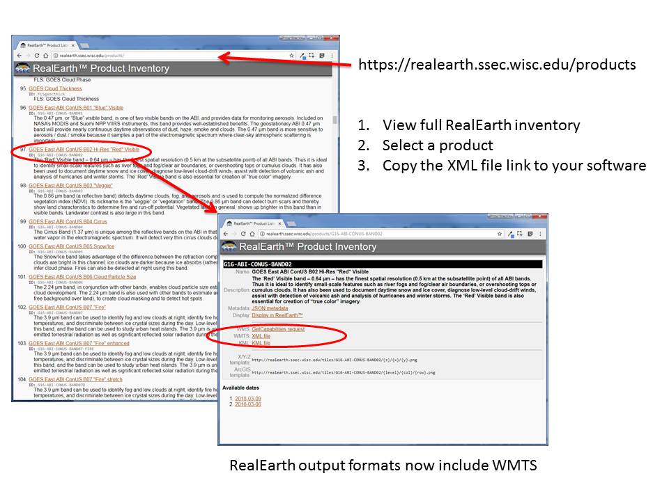
RealEarth Supports OGC Web Mapping Tile Service (WMTS): University of Wisconsin-Madison's Space Science and Engineering Center's RealEarth data visualization platform now supports the Open Geospatial Consortium standard for Web Mapping Tile Service (WMTS). This means that it is even easier and faster to display any of the 600+ RealEarth meteorological and geospatial satellite imagery products in GIS applications such as ESRI's ArcGIS Desktop, ArcGIS Online, Quantum GIS's Desktop software, and any custom client interfaces that can access the RealEarth API (documented here: https://realearth.ssec.wisc.edu/doc/). RealEarth has always offered Web Mapping Service (WMS) access and Keyhole Markup Language (KML) access to its products. However, WMTS improves performance by directing applications to an XML file that provides metadata and systematically draws upon existing cached tiles when they are available. (S. Batzli, SSEC, 608-263-3126)
 (Click image to enlarge)
Figure caption: RealEarth Now Supports WMTS.
VISITORS:
NEXT WEEK:
LOOKING AHEAD:
| Archived Weeklies Page | Submit a report item |