[ Archive ]

 |
CIMSS-NOAA Weekly Report [ Archive ] |
 |
CIMSS AND ASPB WEEKLY HIGHLIGHTS FOR THE WEEK ENDING JANUARY 27, 2023
DATA, INFORMATION, AND USE-INSPIRED SCIENCE:
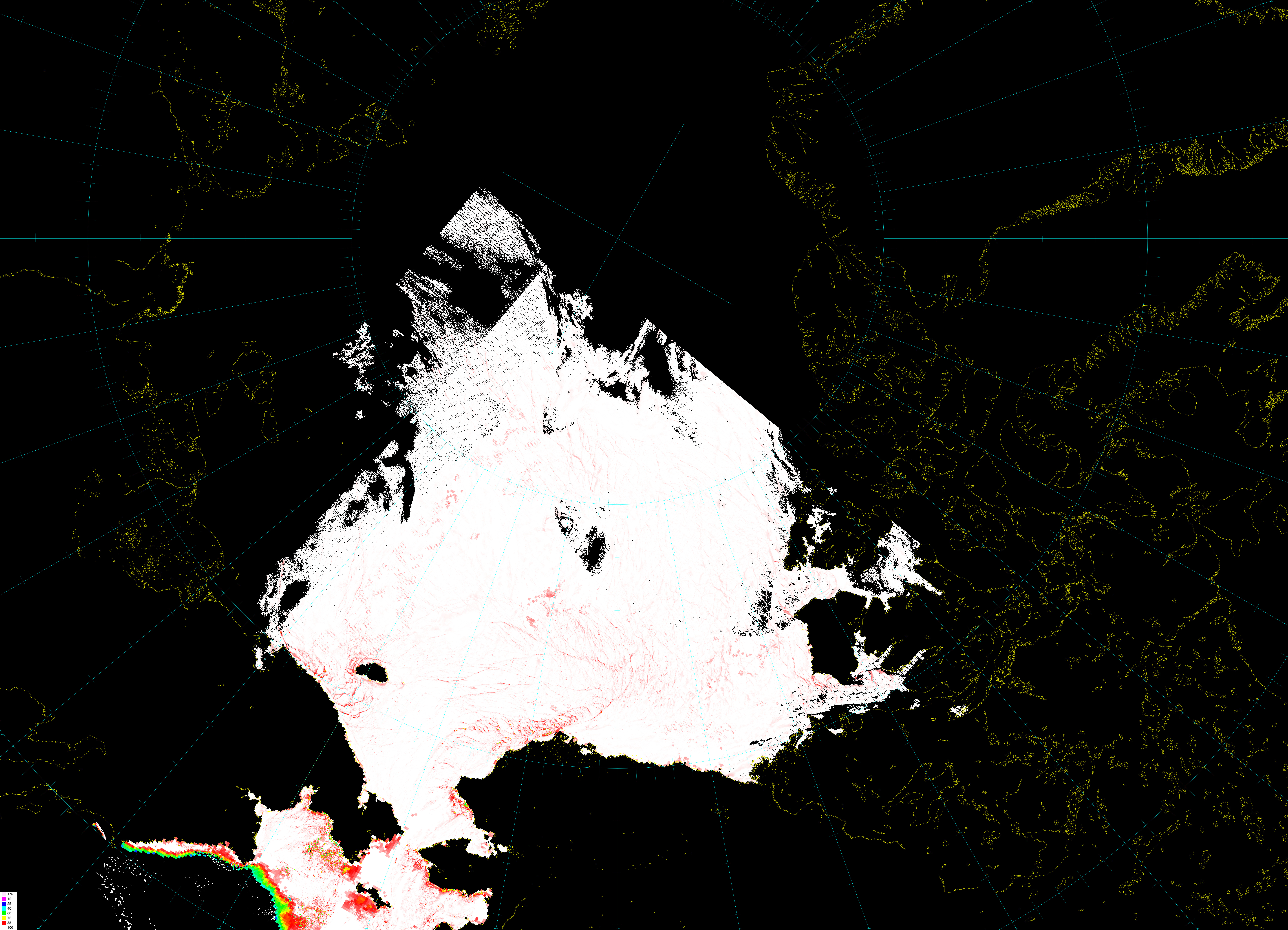
VIIRS-AMSR2 Blended Sea Ice Concentration Product Now Included for Training and Analysis at NWS ASIP: The Cooperative Institute for Meteorological Satellite Studies (CIMSS)/NOAA VIIRS-AMSR2 Blended Sea Ice Concentration product is now available in near real-time over the Alaska Region generated with data from the University of Alaska-Fairbanks (UAF) direct broadcast system. It is included as training for ice analysts at the NWS Anchorage - Alaska Sea Ice Program (ASIP). With the assistance of the UAF Graphical Information Network of Alaska (GINA) group, the CIMSS/NOAA cryosphere team's Blended Sea Ice Concentration product is now being included in a “JPSS Lake & Sea Ice Products via Remote Sensing” micro-lesson. Furthermore, the product will be examined by ASIP analysts for strengths and weaknesses when used in their operations. The goal is to have this experimental product used in operations and to simplify tasks of analysts by including a single automatic product in near real-time that combines the strengths and corrects for weaknesses in each product. The primary strength of VIIRS being its high resolution and AMSR2 being its all-weather capabilities. Having a single, reliable, and accurate ice concentration product will significantly improve efficiency. (R. Dworak, CIMSS, 608-265-8620)
 (Click image to enlarge)
Figure: An example of the blended Sea Ice product from 25 January 2023 at 1403 UTC.
FUTURE OUTLOOK:
AWARDS AND RECOGNITION:
TRAVEL AND MEETINGS:
TRAINING AND EDUCATION:
CIMSS VISIT Training for the Aviation Weather Center (AWC) on 24/25 January 2023: Scott Lindstrom from the Cooperative Institute for Meteorological Satellite Studies (CIMSS) presented two Virtual Institute for Satellite Integration Training (VISIT) modules to a forecaster at NOAA's Aviation Weather Center (AWC). On 24 January, the topic was Instrument Flight Rules (IFR) Probability, the GOES-R Level-2 product for Fog Detection. On 25 January, the topic was NOAA-Unique Combined Atmospheric Processing System (NUCAPS) Profiles. After the training, there was considerable discussion on the two products, including on where they could be found online and in AWIPS (S. Lindstrom, CIMSS, 608 263 4425)
MEDIA INTERACTIONS AND REQUESTS:
SOCIAL MEDIA AND BLOG Posts:
SSEC and CIMSS Scientists in the News: Scientists at the University of Wisconsin-Madison (UW) Space Science and Engineering Center (SSEC) and the Cooperative Institute for Meteorological Satellite Studies (CIMSS) provide expert interviews, imagery and case studies to promote science. This week, CIMSS Satellite Blog contributors Scott Lindstrom, Alexa Ross and Scott Bachmeier published these case studies: "Severe thunderstorms produce tornadoes and damaging winds in Texas and Louisiana" (Jan 24), "Wind shear in the Nighttime Microphysics RGB" (Jan. 24), "The moving shadow of Mt. Shasta" (Jan. 23), "Monthly averages of GOES-17 Brightness Temperatures for Bands 8, 10 and 13" (Jan. 23), "NOAA-20 detection of flooding over California" (Jan. 22), "Industrial Plumes producing light snow over Wisconsin (Jan. 22), "30-second imagery of Mountain Waves over the Mid-Atlantic States" (Jan. 20), "Disturbed weather in the tropics near American Samoa" (Jan. 20) and "Severe Convective Winds over Ohio" (Jan. 20). Read more at the CIMSS Satellite Blog: https://cimss.ssec.wisc.edu/satellite-blog/. (S. Lindstrom, CIMSS, A. Ross, CIMSS, S. Bachmeier, CIMSS, E. Verbeten, SSEC
 (Click image to enlarge)
Figure: 1-minute GOES-16 Infrared and Visible images revealed a series of lightning jumps (rapidly-growing clusters of bright white pixels) minutes after a tornado began to produce damage in the Houston area. Read more at the CIMSS Satellite Blog https://cimss.ssec.wisc.edu/satellite-blog/archives/49997. Credit: CIMSS, NOAA
PUBLICATIONS:
Paper Published on Monitoring Volcanic SO2 Using GEO/LEO Fusion: In the paper titled “Monitoring the 2021 Cumbre Vieja Volcanic Eruption Using Satellite Multi-Sensor Data Fusion,” E. Weisz and W. P. Menzel, Cooperative Institute for Meteorological Satellite Studies (CIMSS), examine the fusion of data from low Earth orbiting (LEO) sensors with that from the geostationary orbiting (GEO) imagers to enhance the detection of trace gas and ash emissions from volcanoes. This yields information with improved spatial detail and, more importantly, with increased temporal resolution to help monitor their variable dispersion. The volcanic sulfur dioxide (SO2) and ash plumes from the Cumbre Vieja volcano (Canary Islands, Spain) eruptions in October 2021 are studied through the synergistic exploitation of measurements and products from the Cross-track Infrared Sounder (CrIS), the TROPOspheric Monitoring Instrument (TROPOMI), and the Advanced Baseline Imager (ABI). The fusion results detail realistic growth and dispersion of the volcanic ash plumes day and night; potential benefits range from improving air quality monitoring to enhancing aircraft safety systems. The paper published in the Journal of Geophysical Research – Atmospheres can be found at https://doi.org/10.1029/2022JD037926. (E. Weisz, SSEC/CIMSS, 608-265-3954)
 (Click image to enlarge)
Figure: ABI/TROPOMI SO2 fusion results in DU, superimposed upon ABI Band 13 (10.3 μm) brightness temperatures. Fusion starts at 15:00 UTC and works forward and backward in 10 min increments to produce the 13:00 to 16:00 UTC results.
OTHER:
| Archived Weeklies Page | Submit a report item |