[ Archive ]
| CIMSS-NOAA Weekly Report [ Archive ] |
CIMSS-NOAA WEEKLY HIGHLIGHTS FOR THE WEEK ENDING MAY 18, 2024
DATA, INFORMATION, AND USE-INSPIRED SCIENCE:
FUTURE OUTLOOK:
AWARDS AND RECOGNITION:
TRAVEL AND MEETINGS:
TRAINING AND EDUCATION:
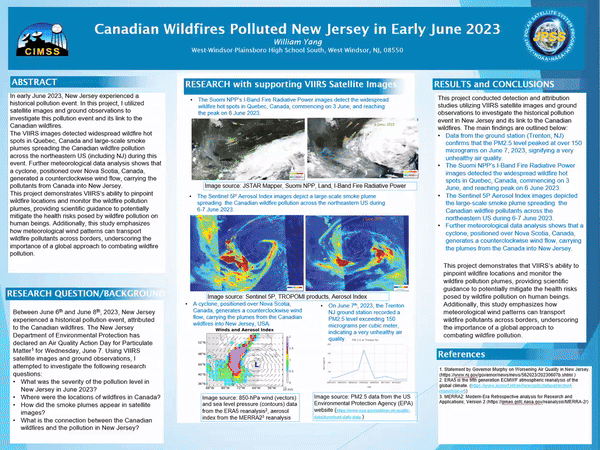
2024 NOAA Satellites Virtual Science Fair (VSF) Top Projects: The 2024 NOAA Satellites Virtual Science Fair competition closed on May 3rd and the top projects can now be viewed online. There are two levels in the VSF: middle and high school, and two categories: geostationary (GOES) and polar-orbiting (JPSS). Students design their own project and employ satellite imagery in their research. Wildfires and the Eclipse were popular topics this year. All submissions must include a poster; high school students are also required to upload videos explaining their project, similar to a poster session at a scientific conference. The VSF is conducted by NOAA’s Cooperative Institute Meteorological Satellite Studies (CIMSS) every school year. (M. Mooney, CIMSS, margaret.mooney@ssec.wisc.edu)
 (Click image to enlarge)
MEDIA INTERACTIONS AND REQUESTS:
SOCIAL MEDIA AND BLOG Posts:
SSEC and CIMSS Scientists in the news: Scientists at the University of Wisconsin-Madison (UW) Space Science and Engineering Center (SSEC) and the Cooperative Institute for Meteorological Satellite Studies (CIMSS) provide expert interviews, imagery and case studies to promote science and satellite imagery. This week: 1) CIMSS Satellite Blog contributors Scott Bachmeier, Scott Lindstrom, and CIMSS Education and Outreach Director Margaret Mooney published the following case studies: "Flooding Rains on Oahu" (May 16); "Smoke over the Gulf of Mexico" (May 14); NUCAPS EDR files in the cloud" (May 14); "Wildfires in British Columbia produce pyrocumulonimbus clouds" (May 13); "Image Archive of the Historic May 11th Geomagnetic Storm" (May 13); NOAA-20 and NOAA-21 NUCAPS profiles provide gap-free coverage" (May 13); "Direct Broadcast views of high AOD values over North America" (May 12); "Wildfires in British Columbia" (May 11); "Aurora over the northern United States" (May 11); "NOAA-21 NUCAPS Profiles (and gridded NUCAPS fields) are now in AWIPS" (May 10). Read more at the CIMSS Satellite Blog. (S. Lindstrom, CIMSS, 608-263-4425; S. Bachmeier, CIMSS; E. Verbeten, SSEC, 608-263-4206)
 (Click image to enlarge)
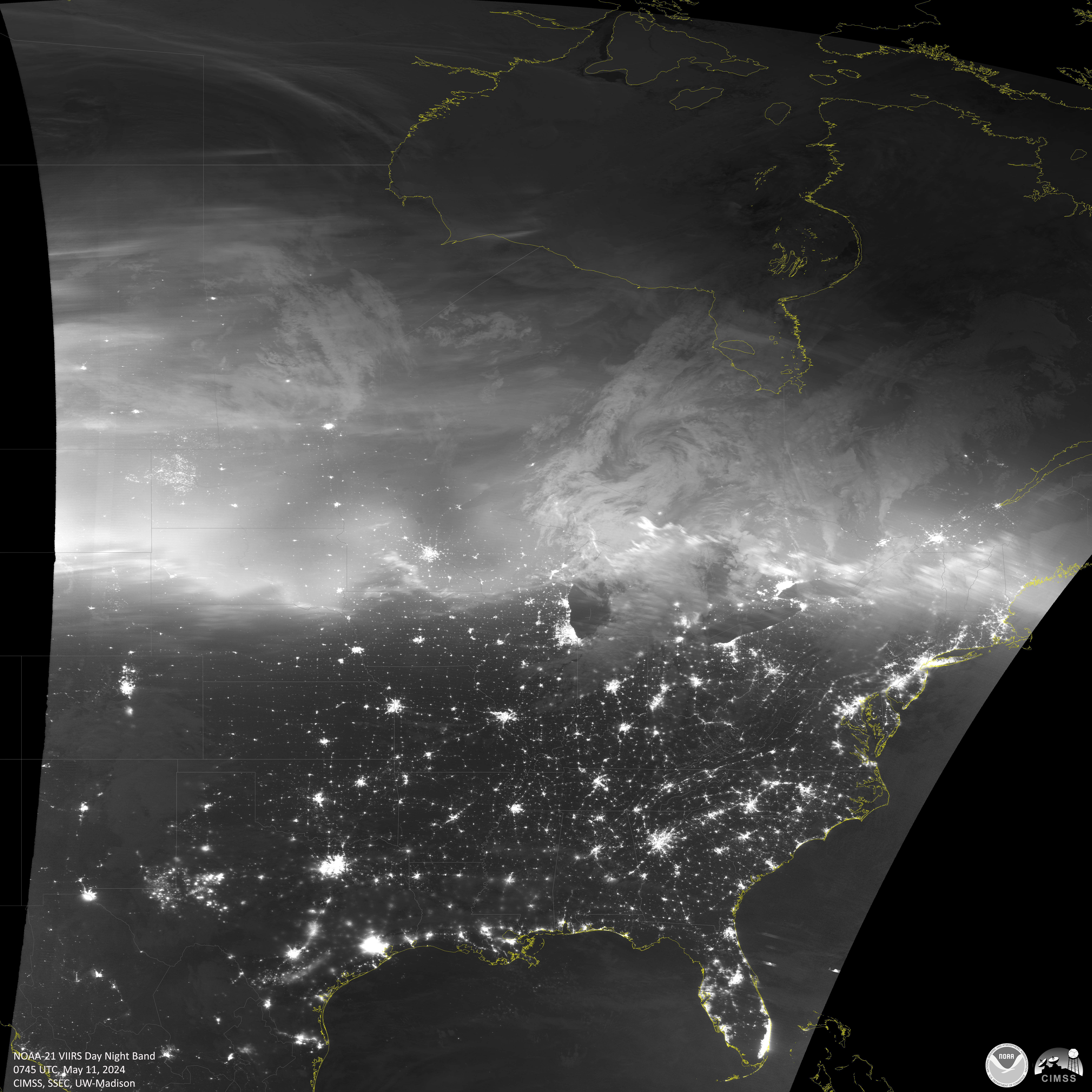
Figure: Thousands if not millions of people took colorful photos of the Northern Lights during the early hours of May 11th during a remarkable G5 geomagnetic storm that expanded Aurora Borealis activity southward to unusually low latitudes in the United States. The JPSS fleet of polar-orbiting spacecraft captured eight monochromatic VIIRS Day Night Band images over North America documenting the historic space weather event from a satellite perspective, archived here for posterity and future research.
PUBLICATIONS:
OTHER:
| Archived Weeklies Page | Submit a report item |