[ Archive ]

 |
CIMSS-NOAA Weekly Report [ Archive ] |
 |
CIMSS-NOAA WEEKLY HIGHLIGHTS FOR THE WEEK ENDING JUNE 14, 2024
DATA, INFORMATION, AND USE-INSPIRED SCIENCE:
FUTURE OUTLOOK:
AWARDS AND RECOGNITION:
TRAVEL AND MEETINGS:
TRAINING AND EDUCATION:
LightningCast Presentation at Australian Virtual Laboratory (VLab) Center of Excellence (COE) Webinar: Scott Lindstrom from the Cooperative Institute for Meteorological Satellite Studies (CIMSS) gave a presentation at the Australian Virtual Laboratory (VLab) Center of Excellence (COE) monthly webinar. The 20-minute talk (followed by discussion) centered on the turbulence encountered by a Singapore Airlines flight from London to Singapore (as discussed in this CIMSS Satellite Blog Post: https://cimss.ssec.wisc.edu/satellite-blog/archives/59382) and how LightningCast probability (shown for the event in this CIMSS Satellite Blog Post: https://cimss.ssec.wisc.edu/satellite-blog/archives/59748) might have been used to alert in advance the pilots to the potential for convectively-generated turbulence. The presentation was recorded and will become available at the VLab COE website (http://www.virtuallab.bom.gov.au/archive/regional-focus-group-recordings/). (S. Lindstrom, CIMSS, 608 263 4425)
MEDIA INTERACTIONS AND REQUESTS:
SOCIAL MEDIA AND BLOG Posts:
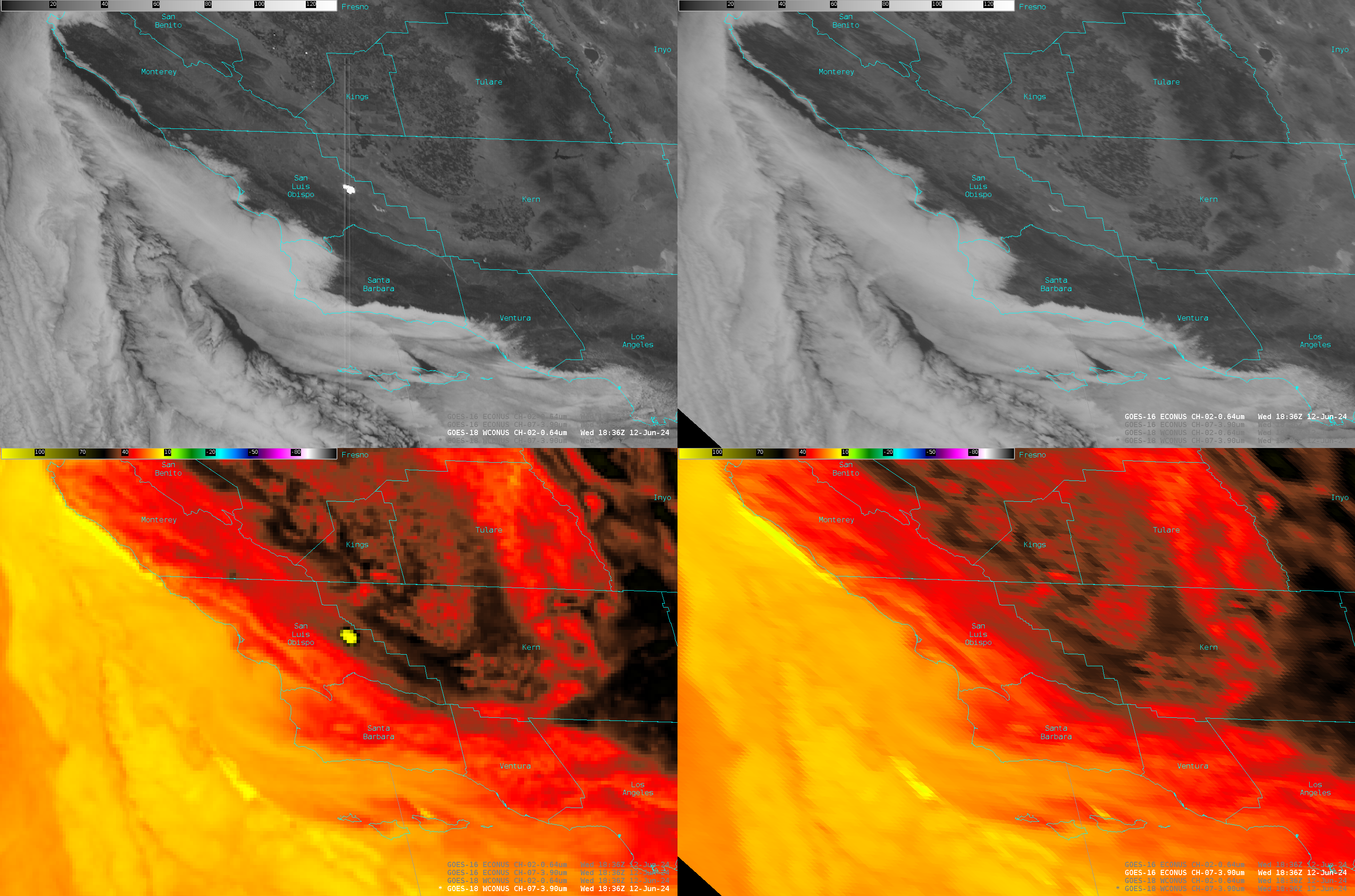
SSEC and CIMSS Scientists in the News: Scientists at the University of Wisconsin-Madison (UW) Space Science and Engineering Center (SSEC) and the Cooperative Institute for Meteorological Satellite Studies (CIMSS) provide expert interviews, imagery and case studies to promote science and satellite imagery. This week: 1) PREFIRE: From May 01 - June 06, 2024, NASA JPL reported that more than 742 news stories were published relating to the PREFIRE mission and recent launches from New Zealand. In total, news stories came from 37 countries including US, India, Australia, New Zealand, Vietnam, China, Russia, Mexico, Bahrain, Nigeria, and Zimbabwe. 2) CIMSS Satellite Blog contributors Scott Bachmeier and Scott Lindstrom, and NOAA scientist Tim Schmit published the following case studies: "The Bear Fire in California and NGFS detection" (June 12); "6-panel SUVI (Solar) Imagery" (June 12); "Heavy rainfall across American Samoa" (June 12); "Record 1-hour rainfall accumulation at Sarasota, Florida" (June 11); "Severe thunderstorms in the northern High Plains" (June 10); "Using LightningCast Probabilities as an aviation tool" (June 10); "Sun glint off open water near the coast of Alaska" (June 08). Read more at the CIMSS Satellite Blog (https://cimss.ssec.wisc.edu/satellite-blog/). (S. Lindstrom, CIMSS, 608-263-4425; S. Bachmeier, CIMSS; T. Schmit, E/RA2, 608-263-0291, tim.j.schmit@noaa.gov; E. Verbeten, SSEC, 608-263-4206
 (Click image to enlarge)
Figure: GOES-18 imagery over California at 1836 UTC show a very strong signal over San Luis Obispo County: very bright in visible imagery and warm in the shortwave infrared (left top and bottom). In the GOES-16 imagery on the right, that signal is not present.
PUBLICATIONS:
OTHER:
| Archived Weeklies Page | Submit a report item |