[ Archive ]
| CIMSS-NOAA Weekly Report [ Archive ] |
CIMSS-NOAA WEEKLY HIGHLIGHTS FOR THE WEEK ENDING JULY 12, 2024
DATA, INFORMATION, AND USE-INSPIRED SCIENCE:
FUTURE OUTLOOK:
AWARDS AND RECOGNITION:
TRAVEL AND MEETINGS:
Intersessional meeting of the ITWG Products and Software group: As part of a series of intersessional meetings that are being held by the International TOVS Working Group (ITWG) this summer, a virtual meeting of the Products and Software Working Group (PSWG) was held on July 11. The meeting was attended by users of sounder satellite data, software providers and data providers from around the world. Briefings were given on plans for new and future satellite systems and instruments, including Indian National Satellite - 3D second repeat (INSAT-3DS), Oceansat-3, Geostationary Extended Observations (GeoXO), QuickSounder, and Arctic Weather Satellite. Updates were presented on Direct Broadcast Network (DBNet) and software packages available to process sounder data. Progress toward open actions was reviewed, and topics of current interest to the satellite community were discussed, such as Principal Component compression of sounder data, and best practices for software distribution. The meeting was chaired by Anna Booton (UK Met Office) and Graeme Martin (Cooperative Institute for Meteorological Satellite Studies). (G. Martin, CIMSS, 608-263-6792)
TRAINING AND EDUCATION:
VISIT Teletraining for Tampa Forecast Office: Scott Lindstrom from the Cooperative Institute for Meteorological Satellite Studies (CIMSS) presented two Virtual Institute for Satellite Integration Training (VISIT) modules to a forecaster at the forecast office in Tampa FL. The first module described Mesoscale Convective Vortices (MCVs) and the second described NOAA-Unique Combined Atmospheric Profiling System (NUCAPS) profiles of thermodynamic information. NUCAPS Profiles are especially relevant to Tampa because of the data voids over the Gulf of Mexico and over the tropical Atlantic. The presentations were shared with the forecaster after the training. (S. Lindstrom, CIMSS, 608 263 4425)
MEDIA INTERACTIONS AND REQUESTS:
CIMSS Scientist Provides Local Media Interview Concerning Hurricane Beryl: CIMSS scientist Derrick Herndon appeared on WISC-TV in Madison to discuss the unprecedented intensity attained by Hurricane Beryl for so early in the hurricane season. Beryl was first storm on record to reach Category 4 intensity in June, the earliest storm to reach Category 5 and the highest amount of Accumulated Cyclone Energy this early in the season. The storm also produced a record number of tornado warnings over Texas, Louisiana and Arkansas. Record warm Atlantic ocean temperatures and unseasonably favorable upper level winds were noted as the primary cause for Beryl's record-breaking intensity. (D. Herndon, CIMSS, 608-262-6741)
SOCIAL MEDIA AND BLOG Posts:
SSEC and CIMSS Scientists in the News: Scientists at the University of Wisconsin-Madison (UW-Madison) Space Science and Engineering Center (SSEC) and the Cooperative Institute for Meteorological Satellite Studies (CIMSS) provide expert interviews, imagery and case studies to promote science and satellite imagery. This week: CIMSS Satellite Blog contributors Scott Lindstrom and Tim Schmit published the following case studies: "Large Haboob over New Mexico and parts of Mexico" (July 11); "Record Heat in the Pacific Northwest" (July 10); "GOES Launch Pad Listing over the Decades" (July 08); "Beryl makes landfall along the Texas Gulf Coast" (July 08); 'Beryl makes landfall over the Yucatan Peninsula" (July 05). Read more at the CIMSS Satellite Blog (https://cimss.ssec.wisc.edu/satellite-blog/. (S. Lindstrom, CIMSS,T. Schmit, E/RA2, 608-263-0291, tim.j.schmit@noaa.gov, E. Verbeten, SSEC, 608-263-4206.
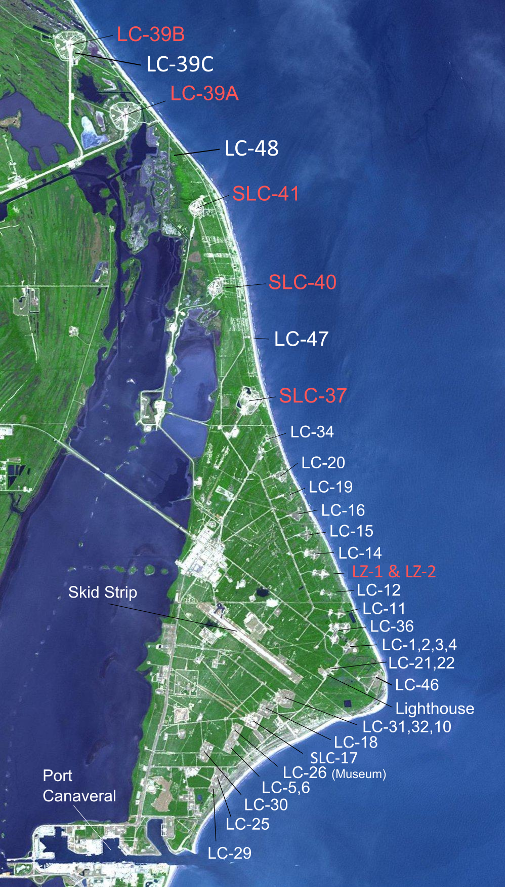 (Click image to enlarge)
Figure: Map of launch complexes on Merritt Island and Cape Canaveral.
PUBLICATIONS:
Weather satellite nowcasting review paper published: A manuscript titled, "Quantitative Applications of Weather Satellite Data for Nowcasting: Progress and Challenges " was published in the Journal of Meteorological Research (http://jmr.cmsjournal.net/article/doi/10.1007/s13351-024-3138-6). This work overviews the recent progress on the quantitative applications of weather satellites for severe storm nowcasting, including current status, challenges, and future perspectives. The paper highlights the importance and usefulness of satellite data in pre-convective environment for situational awareness and storm warnings. The local co-authors are Zhenglong Li, Paul Menzel, Timothy Schmit, John Cintineo, Scott Lindstrom, and Scott Bachmeier. The citation of the paper is Li, J., J. Zheng, B. Li, M. Min, Y. Liu, C-Y Liu, Z. Li, W.P. Menzel, T.J. Schmit, J.L. Cintineo, S. Lindstrom, S. Bachmeier, Y. Xue, Y. Ma, D. Di, and H. Lin, 2024: Quantitative applications of weather satellite data for nowcasting: Progress and challenges. J. Meteor. Res.,38(3), 399-413, doi: 10.1007/s13351-024-3138-6. (Zhenglong Li, 608-890-1982, zhenglong.li@ssec.wisc.edu).
OTHER:
| Archived Weeklies Page | Submit a report item |