[ Archive ]
| CIMSS-NOAA Weekly Report [ Archive ] |
CIMSS-NOAA WEEKLY HIGHLIGHTS FOR THE WEEK ENDING MARCH 7, 2025
DATA, INFORMATION, AND USE-INSPIRED SCIENCE:
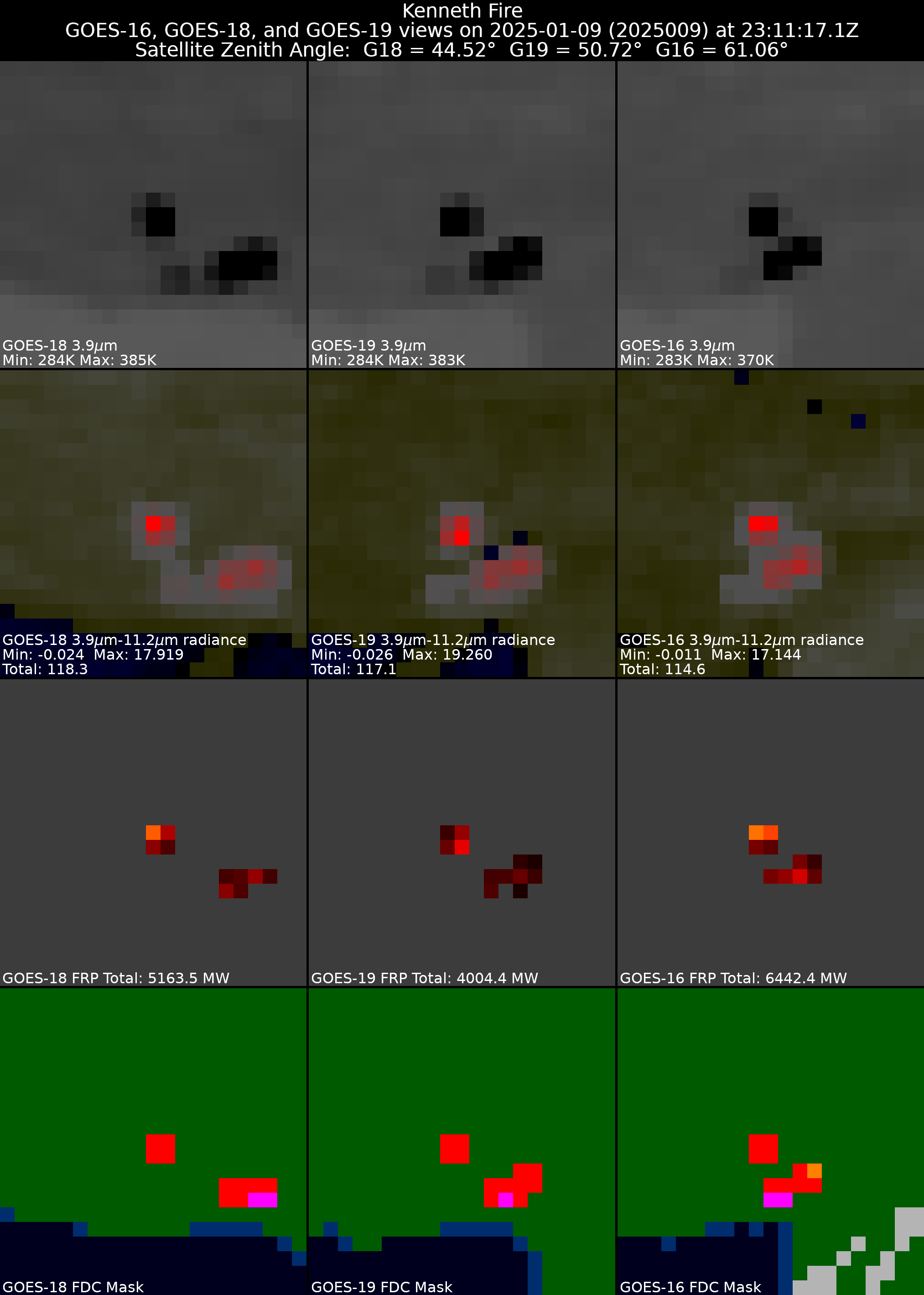
Milestone: GOES-19 ABI Fires Algorithm Provisional Maturity: Researchers from the Cooperative Institute for Meteorological Satellite Studies (CIMSS) and NOAA on the GOES-R Algorithm Working Group (AWG) Fires Team presented at the GOES-19 Advanced Baseline Imager (ABI) Provisional Peer Stakeholder-Product Validation Review (PS-PVR) on March 5, 2025. The Fires Team maintains and reports on the ABI Fire Detection and Characterization Algorithm (FDCA), a baseline ABI product that provides fire detections and fire properties to a wide range of users, including but not limited to the National Weather Service and smoke and aerosol modelers. The presentation showed that the algorithm’s detection and characterization of fires is consistent between GOES-19, GOES-16, and GOES-18. The GOES-19 FDCA was granted provisional status after the review. More information will be posted at https://www.noaasis.noaa.gov/GOES/PS_PVR_GOES19.html. (C. Schmidt, CIMSS, 608-262-7973, chris.schmidt@ssec.wisc.edu)
 (Click image to enlarge)
Figure: GOES-16/-18/-19 ABI views of the Palisades and Kenneth Fires on January 9, 2025 showing different metrics used to demonstrate that similar performance of the algorithm between the different satellites. The GOES-19 ABI data is preliminary and non-operational.
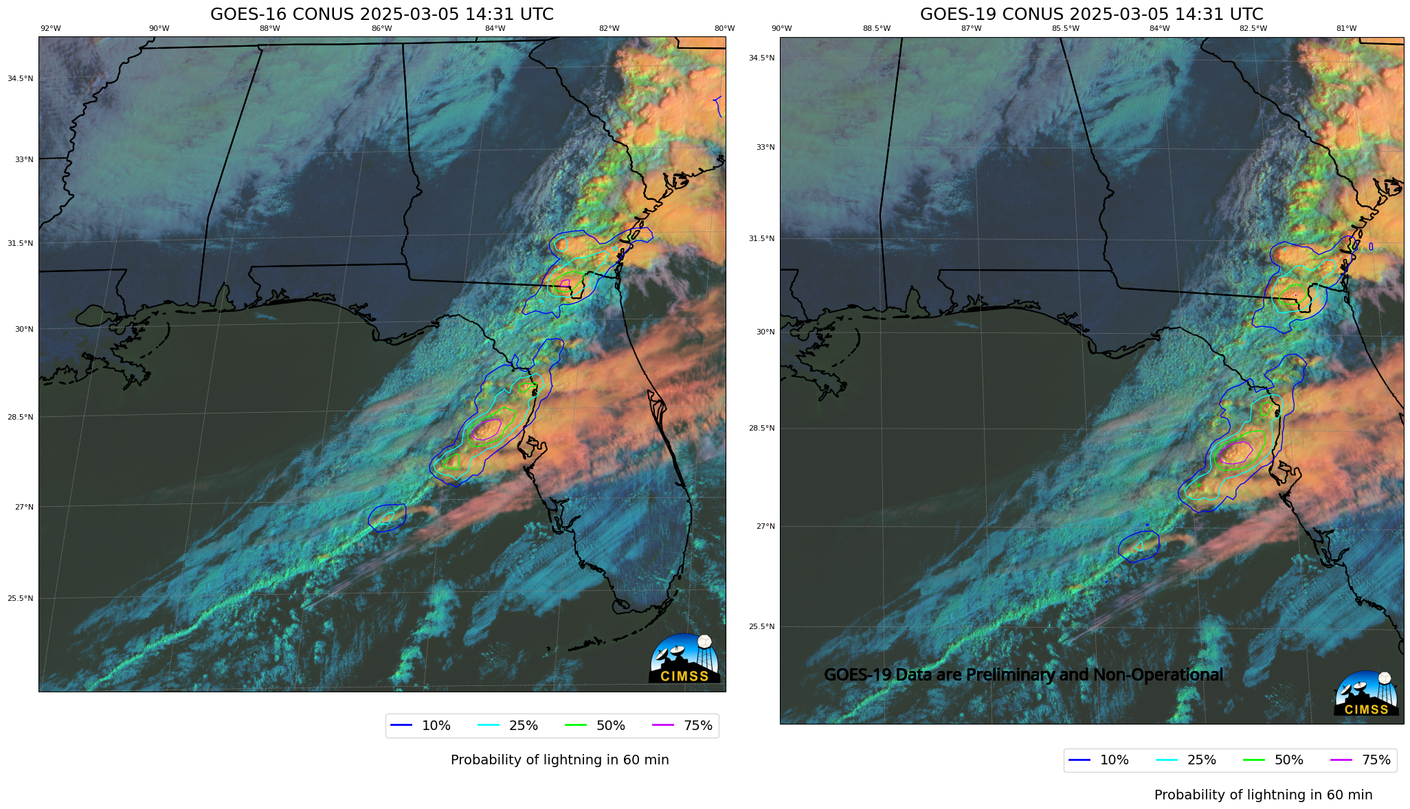
CSPP Geo releases new beta version of LightningCast probability software: The CSPP Geo (Community Satellite Processing Package for Geostationary Data) software group at CIMSS (Cooperative Institute for Meteorological Satellite Studies) has released a new beta version of software that computes LightningCast Probabilities, available for free download at this website: https://cimss.ssec.wisc.edu/csppgeo/lightningcast_v1.0b2.html. The new beta incorporates support for GOES-19, scheduled to become operational as GOES-East in early April. More details and a few examples are available here: https://cimss.ssec.wisc.edu/satellite-blog/archives/63316. (G. Martin, L. Pfantz, J. Braun, S. Lindstrom, CIMSS ; J. Cintineo NOAA/OAR)
 (Click image to enlarge)
Figure: LightningCast probabilities at 1431 UTC on 5 March from GOES-16 (left) and GOES-19 (right).
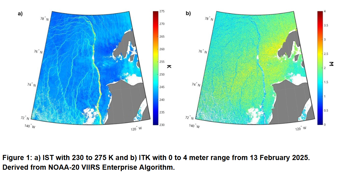
VIIRS Ice Surface Temperature and Thickness Products Detect a Very Large Sea Ice Lead in the Eastern Beaufort Sea: VIIRS sea ice products detected a particularly large lead (a fracture of the sea ice) over the eastern Beaufort Sea on 13 February 2025. This lead extended from near the southern coast of Banks Island northward into the central Arctic northwest of Prince Patrick Island. The lead is roughly 700+ km long and 10-15 km wide (see figure). Sea ice leads tend to be under 100 km in length and under 1 km in width. Therefore, the size of this lead is unusual. Numerous smaller leads are observed to the west of the main feature. The large lead is much warmer than the surrounding ice and contains substantially thinner ice. It was observed to be at its largest on 13 February, after which it gradually closes over next couple weeks. (R. Dworak, CIMSS, 608-265-8620)
 (Click image to enlarge)
FUTURE OUTLOOK:
AWARDS AND RECOGNITION:
TRAVEL AND MEETINGS:
TRAINING AND EDUCATION:
MEDIA INTERACTIONS AND REQUESTS:
SOCIAL MEDIA AND BLOG Posts:
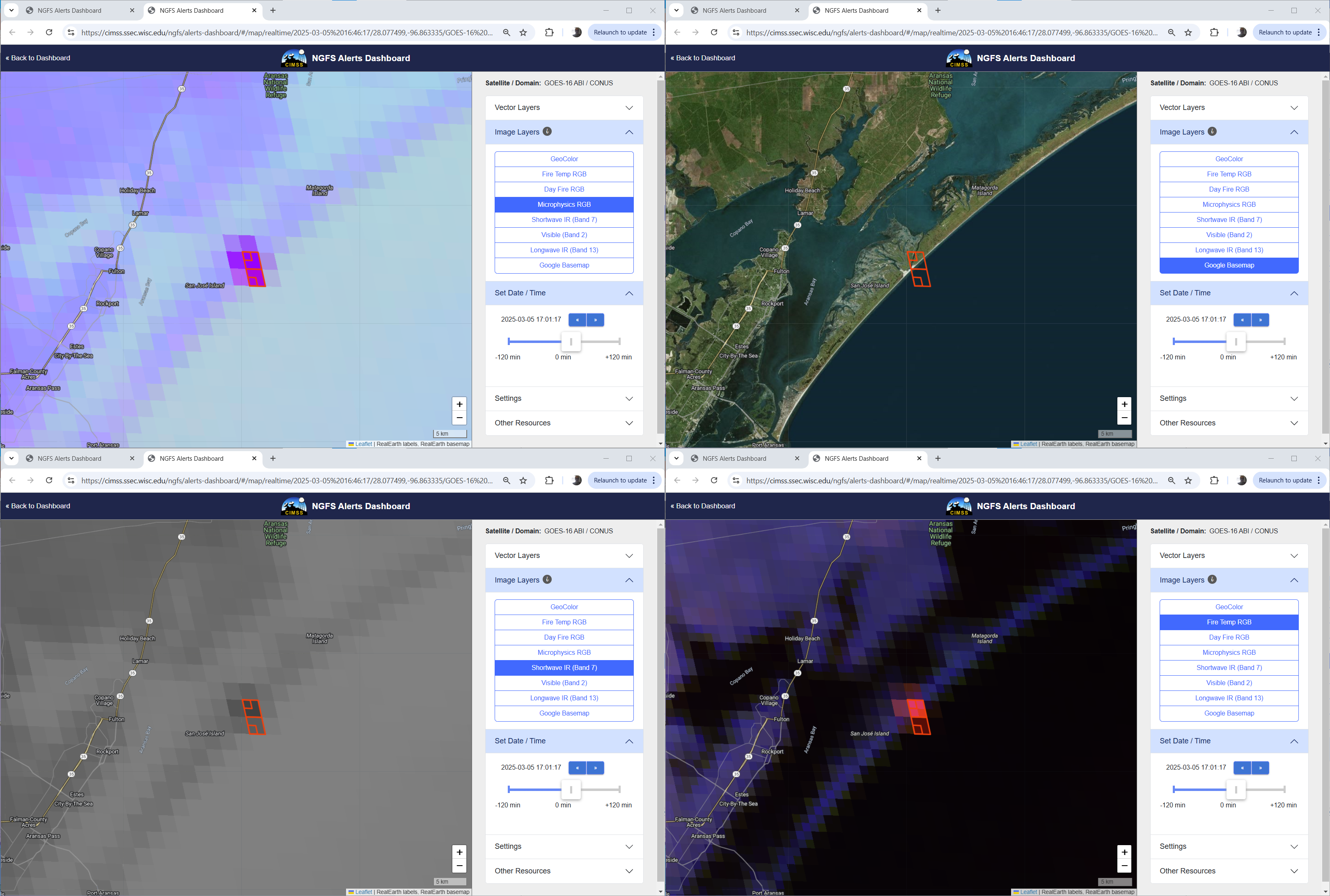
This week on the CIMSS Satellite Blog: The CIMSS Satellite Blog showcases events that demonstrate the beauty and utility of NOAA Satellite Imagery (from both Geostationary and Low-Earth Orbit satellites). This week's offerings include: Microwave snowfall rates over southeast Alaska; One Long Lake-Effect Snow Band in February; We get letters, MODIS True Color edition; Blowing dust across eastern New Mexico and western Texas; Beta version of CSPPGeo LightningCast software now supports GOES-19; and NGFS Detection of a barrier island wildfire in Texas: GOES and VIIRS. (S. Lindstrom, S. Bachmeier, CIMSS; 608 263 4425)
 (Click image to enlarge)
Figure: NGFS imagery for a wildfire on the barrier islands east of Corpus Christi TX, 1701 UTC on 5 March 2025. See Blog Post (https://cimss.ssec.wisc.edu/satellite-blog/archives/63324) for details.
PUBLICATIONS:
Manuscript on the Impact of GEO Sounder on Tropical Cyclone Forecasts Published: A manuscript titled "Impacts of Thermodynamic and Dynamic Information from the Geostationary Hyperspectral Infrared Sounder on Tropical Cyclone Forecasts" has been published in Journal of Geophysical Research: Atmospheres (https://agupubs.onlinelibrary.wiley.com/doi/abs/10.1029/2024JD042194). The coauthors include Yan-An Liu (lead author and former CIMSS visitor), Jun Li (CIMSS Distinguished Scientist Emeritus), and Zhenglong Li (CIMSS). This paper demonstrates that assimilating thermodynamic and dynamic profile information from the Geostationary Interferometric Infrared Sounder enhances both the analysis and forecasts of tropical cyclones, improving track and intensity predictions. Specifically, the assimilation of wind profiles significantly improves track forecasts. This study provides evidence of the future value of the GeoXO Sounder for tropical cyclone applications. (Z. Li, CIMSS, 608-890-1982)
OTHER:
| Archived Weeklies Page | Submit a report item |