[ Archive ]
| CIMSS-NOAA Weekly Report [ Archive ] |
CIMSS-NOAA WEEKLY HIGHLIGHTS FOR THE WEEK ENDING MAY 30, 2025
DATA, INFORMATION, AND USE-INSPIRED SCIENCE:
FUTURE OUTLOOK:
AWARDS AND RECOGNITION:
TRAVEL AND MEETINGS:
TRAINING AND EDUCATION:
MEDIA INTERACTIONS AND REQUESTS:
SOCIAL MEDIA AND BLOG Posts:
CIMSS Satellite Blog Entries for the week: Each week, Cooperative Institute for Meteorological Satellite Studies (CIMSS) Scientists post short blog entries that highlight the capabilities of NOAA Satellites, showing how the data can be used to help with nowcasting, or to understand the atmosphere, or to monitor the present weather. For the week ending 30 May 2025, the following entries were created: Nopiming Provincial Park wildfire continues to burn in far eastern Manitoba (https://cimss.ssec.wisc.edu/satellite-blog/archives/64940); Strong Thunderstorms in the Fairbanks, Alaska area (https://cimss.ssec.wisc.edu/satellite-blog/archives/64975); ACSPO estimates of SSTs in the Gulf of Maine (https://cimss.ssec.wisc.edu/satellite-blog/archives/64993); Tropical invest over the eastern Pacific Ocean (https://cimss.ssec.wisc.edu/satellite-blog/archives/64978); Satellite signatures of the SpaceX Starship Flight Test 9 launch (https://cimss.ssec.wisc.edu/satellite-blog/archives/65020); Heavy Rain on American Samoa (https://cimss.ssec.wisc.edu/satellite-blog/archives/65008); Pyrocumulonimbus clouds spawned by a Wildfire in British Columbia (https://cimss.ssec.wisc.edu/satellite-blog/archives/65041); Tropical Storm Alvin forms in the eastern Pacific Ocean (https://cimss.ssec.wisc.edu/satellite-blog/archives/65046). (S. Bachmeier, S. Lindstrom, CIMSS; 608 253 4425)
 (Click image to enlarge)
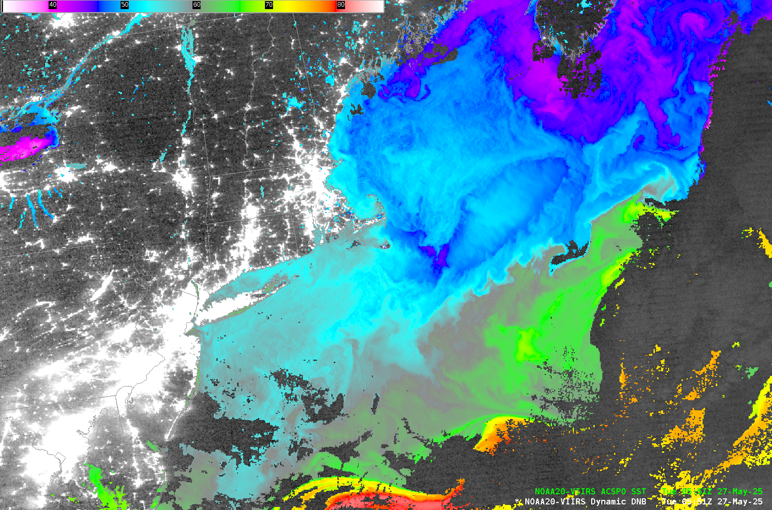
Figure: VIIRS ACSPO SSTs and Day Night Band Visible Imagery over the Gulf of Maine, 0551 UTC on 27 May 2025.
 (Click image to enlarge)
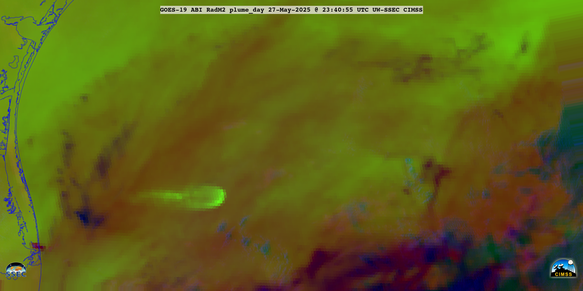
Figure: GOES-19 Plume RGB over the Gulf of Mexico, 2340 UTC, 27 May 2025, showing the rocket plume from SpaceX Starship Flight Test 9.
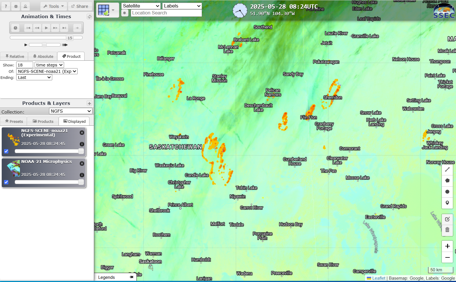
CIMSS Satellite Blog Post comparing NGFS detections from GOES and VIIRS: Scientists at the Cooperative Institute for Meteorological Satellite Studies (CIMSS) are collaborating with scientists at the Geographic Information Network of Alaska (GINA) in Fairbanks, AK, to create Next-Generation Fire System (NGFS) detections with VIIRS data downloaded (in a timely manner) at direct broadcast antennas such as those in Madison WI and in Fairbanks AK. VIIRS offers much better horizontal spatial resolution than GOES over Canada and Alaska. A CIMSS Satellite Blog Post ("Comparing GOES and VIIRS NGFS detections over Canada" (https://cimss.ssec.wisc.edu/satellite-blog/archives/65027) shows a simple comparison (GOES v. VIIRS) in detection over the many wildfires over Manitoba and Saskatchewan in late May, fires that threaten to send smoke into the northern USA in early June). (M. Pavolonis, NOAA/NESDIS/CIMSS ; J. Sieglaff, S. Lindstrom, CIMSS. 608 263 4425)
 (Click image to enlarge)
Figure: RealEarth presentation of VIIRS NGFS fire detections over Saskatchewan and Manitoba, 0824 UTC on 28 May 2025.
PUBLICATIONS:
OTHER:
| Archived Weeklies Page | Submit a report item |