[ Archive ]
| CIMSS-NOAA Weekly Report [ Archive ] |
CIMSS-NOAA WEEKLY HIGHLIGHTS FOR THE WEEK ENDING JUNE 13, 2025
DATA, INFORMATION, AND USE-INSPIRED SCIENCE:
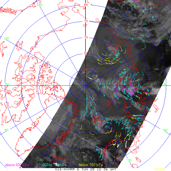
NOAA-18 Polar-orbiting Satellite Decommissioned: NOAA-18, which was launched in May 2005, was decommissioned on 06 June 2025 after 20 years of service. One of the primary products throughout its lifetime was the polar winds, which were derived from the Advanced Very High Resolution Radiometer (AVHRR) instrument. The polar winds were produced operationally at NOAA/NESDIS for many years, and routine generation was continued at the Cooperative Institute for Meteorological Satellite Studies (CIMSS) when NOAA-18 was no longer operational after 2018. Several global numerical weather prediction centers continued to use the CIMSS-produced NOAA-18 polar winds product, including the US Navy’s Fleet Numerical Meteorology & Oceanography Center (FNMOC), the NASA Global Modeling and Assimilation Office (GMAO), and the UK Met Office. Polar wind generation remains ongoing at CIMSS from the two remaining NOAA low-earth orbiting (LEO) satellites, NOAA-15 and NOAA-19. However, these two satellites will be decommissioned in the coming months, marking the end of an era for data from the AVHRR on the NOAA fleet of heritage LEO satellites. (D. Santek, CIMSS, 608-263-7410; J. Key, CIMSS, 608-890-4239)
 (Click image to enlarge)
Figure: The last wind set derived from NOAA-18 AVHRR images on 06 June 2025 at 1236 UTC centered on the North Pole. The wind barbs are color-coded by pressure: Magenta (above 400 hPa), cyan (400 to 700 hPa), yellow (below 700 hPa).
FUTURE OUTLOOK:
AWARDS AND RECOGNITION:
TRAVEL AND MEETINGS:
WMO Snow Observations working meeting: The World Meteorological Organization (WMO) held a Snow Observations Rolling Review of Requirements (RRR) working meeting at the European Centre for Medium-Range Forecasts (ECMWF) in Reading, UK, June 10-12, 2025. The purpose of the meeting was to discuss gaps in the snow observing system and to begin drafting the snow portion of the Statement of Guidance for Cryosphere Applications (SoG), which is effectively a gap analysis for the cryosphere observing system. Jeff Key, Cooperative Institute for Meteorological Satellite Studies (CIMSS), participated remotely. Key is the WMO Cryosphere Earth System Application Category (ESAC) Coordinator and the lead on the development of the Cryosphere SoG. He presented the status of the SoG, and also presented lessons learned from the process. The sea ice portion of the Cryosphere SoG is essentially complete; the snow portion will be completed by the end of this year. It was a very productive meeting! (J. Key, CIMSS, 608-890-4239)
TRAINING AND EDUCATION:
MEDIA INTERACTIONS AND REQUESTS:
SOCIAL MEDIA AND BLOG Posts:
CIMSS Satellite Blog Updates: The Cooperative Institute for Meteorological Satellite Studies (CIMSS) Satellite Blog (https://cimss.ssec.wisc.edu/satellite-blog/) was updated with the following posts: "Canadian wildfire smoke over Alaska" (Jun. 11), "Barbara and Cosme in the eastern Pacific Ocean" (Jun. 9), "Severe thunderstorms produce tornadoes, giant hail and damaging winds across parts of Texas and Oklahoma" (Jun. 8), "Anticipating rain development over Tutuila, American Samoa" (Jun. 8) and "Farewell, NOAA-18" (Jun. 6). (S. Bachmeier, S. Lindstrom, 608.263.4425, D. Schumacher, CIMSS)
 (Click image to enlarge)
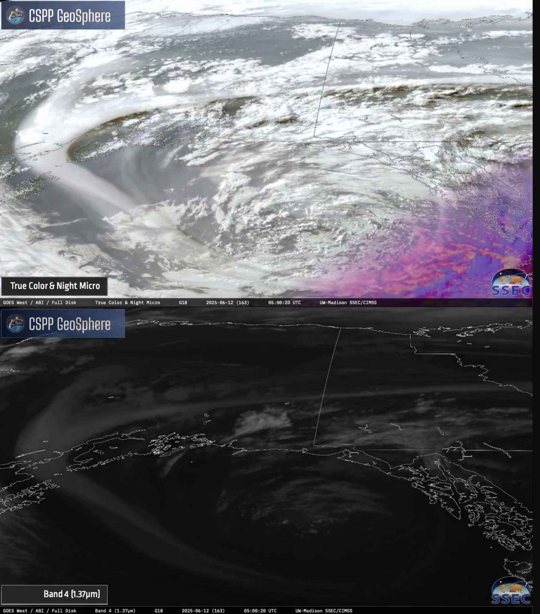
Figure: GOES-18 True Color RGB image (top) and Near-Infrared “Cirrus” (1.37 µm) image (bottom) at 0500 UTC on 12 June 2025, showing a plume of Canadian wildfire smoke that had wrapped around the periphery of a large low pressure system in the Gulf of Alaska.
 (Click image to enlarge)
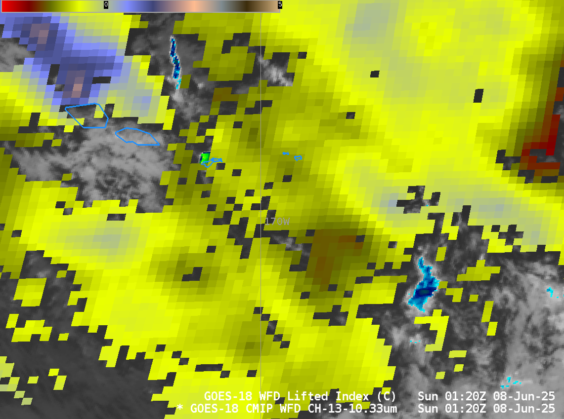
Figure: Derived Lifted Index (in clear skies, scaled from -3 to 5) plotted over GOES-18 Clean Window infrared (Band 13, 10.3 µm) imagery at 0120 UTC on 8 June 2025, showing the unstable atmosphere surrounding American Samoa around the time of convective initiation over the islands.
PUBLICATIONS:
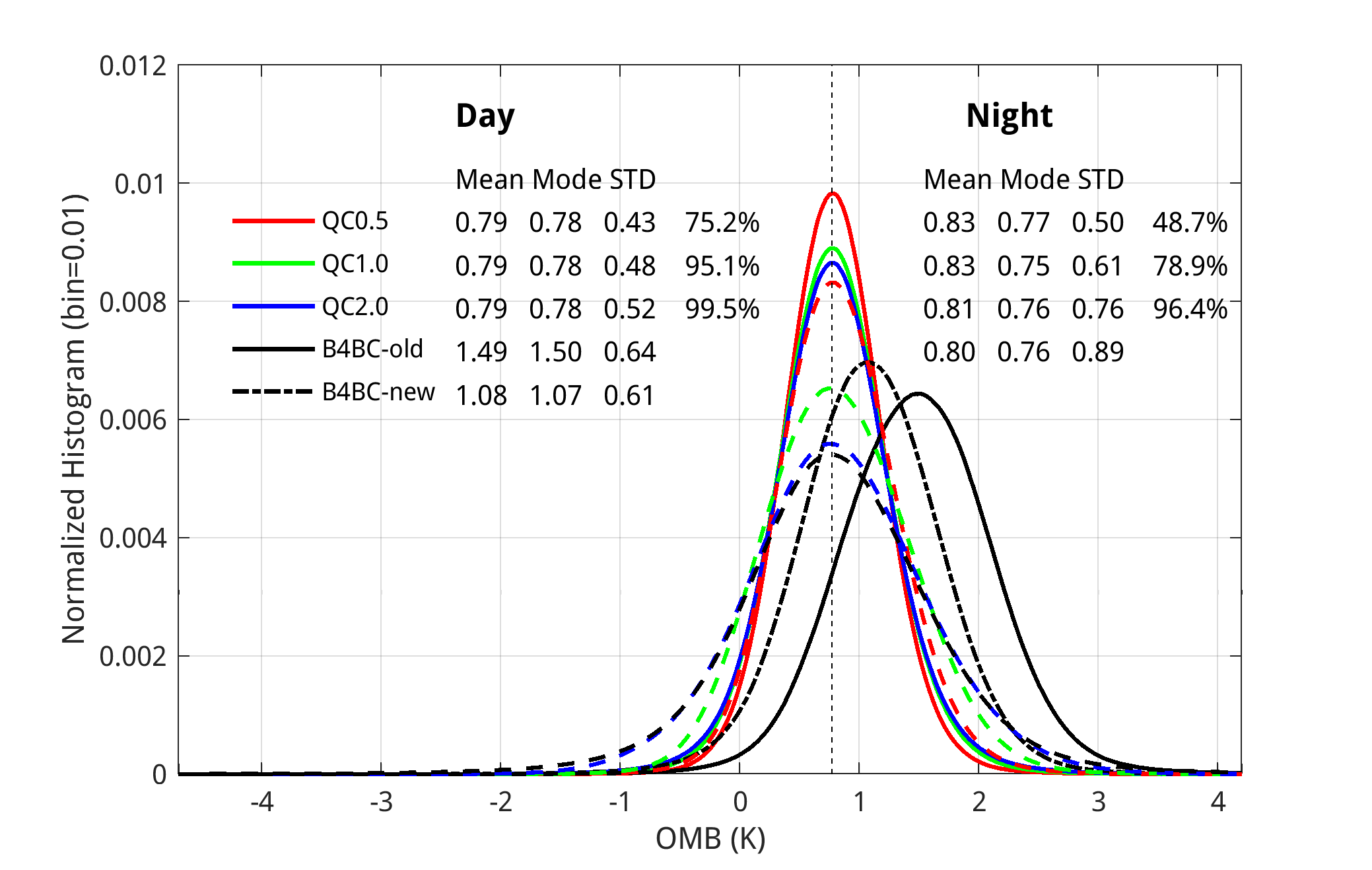
Paper on shortwave infrared radiance assimilation published: A manuscript titled, "Exploration of the use of short-wave infrared radiances in weather forecasts: Part I. Methodologies for bias correction and quality control" was published in Quarterly Journal of the Royal Meteorological Society. A bias correction scheme and a quality control scheme were developed to minimize the day/night discrepancies in observation minus background biases. Evaluations show that the schemes reduced day/night discrepancies to less than 0.1 K for different seasons and 0.14 K for different satellite zenith angles. These small discrepancies open the potential to assimilate daytime and nighttime shortwave infrared radiances simultaneously. The citation is Li, Z., Lim, A.H.N., Jung, J.A., Schmit, T.J., Li, J., Menzel, W.P., et al. (2025) Exploration of the use of short-wave infrared radiances in weather forecasts: Part I. Methodologies for bias correction and quality control. Quarterly Journal of the Royal Meteorological Society, e5020. Available from: https://doi.org/10.1002/qj.5020. This work was supported by JPSS proving ground and risk reduction. (Zhenglong Li, 608-890-1982, zhenglong.li@ssec.wisc.edu)
 (Click image to enlarge)
Figure: The normalized histograms of Cross track Infrared Sounder Full Spectral Resolution (CrIS-FSR)/NOAA-20 wavenumber 2320.625 cm−1. The solid lines are for daytime and dashed lines for nighttime. Red/green/blue lines use fixed thresholds of 0.5, 1.0, and 2.0 K, respectively, as the thresholds to reject observations. The black lines are for daytime before the bias correction using old (solid) and new (dash-dotted) coefficients, and after the bias correction (dashed). OMB, observation minus background; STD, standard deviation.
OTHER:
| Archived Weeklies Page | Submit a report item |