[ Archive ]
| CIMSS-NOAA Weekly Report [ Archive ] |
CIMSS-NOAA WEEKLY HIGHLIGHTS FOR THE WEEK ENDING JULY 4, 2025
DATA, INFORMATION, AND USE-INSPIRED SCIENCE:
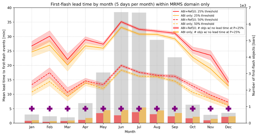
CIMSS Scientists Working on ProbSevere LightningCast Improvements: To improve the ProbSevere LightningCast model v1 (ABI-only predictors; currently scheduled for operations), CIMSS (Cooperative Institute for Meteorological Satellite Studies) scientists tested LightningCast v2, which uses ABI inputs along with an additional input of MRMS (Multi-Radar/Multi-Sensor System) reflectivity at -10C (Ref10). Overall, results show that including the Ref10 predictor improves predictions significantly where radar coverage is valid, while not significantly reducing performance in regions outside of radar coverage. Furthermore, the lead time to lightning initiation events is significantly improved in certain situations (e.g., for shallow convection and for convection developing underneath thick ice). Both LightningCast models (v1 and v2) were demonstrated and evaluated by forecasters at the 2025 HWT (Hazardous Weather Testbed). Numerous blog posts were created by CIMSS scientists and HWT forecasters highlighting LightningCast v2 improvements. NOAA/NESDIS recently highlighted LightningCast's predictive ability as part of a series of articles for Lightning Safety Awareness Week. (L. Heuscher, J. Sieglaff, CIMSS, 608-265-5357; J. Cintineo NOAA/OAR)
 (Click image to enlarge)
Figure: Monthly mean lead time to first-flash events within the MRMS domain (CONUS) for LightningCast v1 (ABI only, orange) and LightningCast v2 (ABI + Ref10, red), for two probability thresholds. Purple “+” indicates that the mean of the red line is statistically greater than the mean of the orange line at the 25% threshold (i.e., p < 0.01).
PEOPLE, AWARDS AND RECOGNITION:
TRAVEL AND MEETINGS:
TRAINING AND EDUCATION:
MEDIA INTERACTIONS AND REQUESTS:
SOCIAL MEDIA AND BLOG Posts:
CIMSS Satellite Blog Updates: The Cooperative Institute for Meteorological Satellite Studies (CIMSS) Satellite Blog was updated with the following posts: "Welcome to Summer! (Summer Solstice 2025)" (Jun. 27), "Wildfire in the Northwest Territories produces a large pyrocumulonimbus cloud" (Jun. 28), "Tropical Depression 2 becomes Tropical Storm Barry in the far southwestern Gulf of Mexico" (Jun. 29), "Smog with light winds over Kyushu" (Jun. 30), "Satellite signatures of the EUMETSAT MTG-S1 launch" (Jul. 1), "Explosion of a fireworks facility in Esparto, California" (Jul. 1) and "Welcome to Space, Meteosat 13!" (Jul. 2). (S. Bachmeier, M Gunshor, S. Lindstrom, T. Wagner, CIMSS)
![]() (Click image to enlarge)
(Click image to enlarge)
Figure: CIMSS Natural Color RGB image at 2300 UTC on June 20, 2025 - the day of the Northern Hemisphere Summer Solstice.
 (Click image to enlarge)
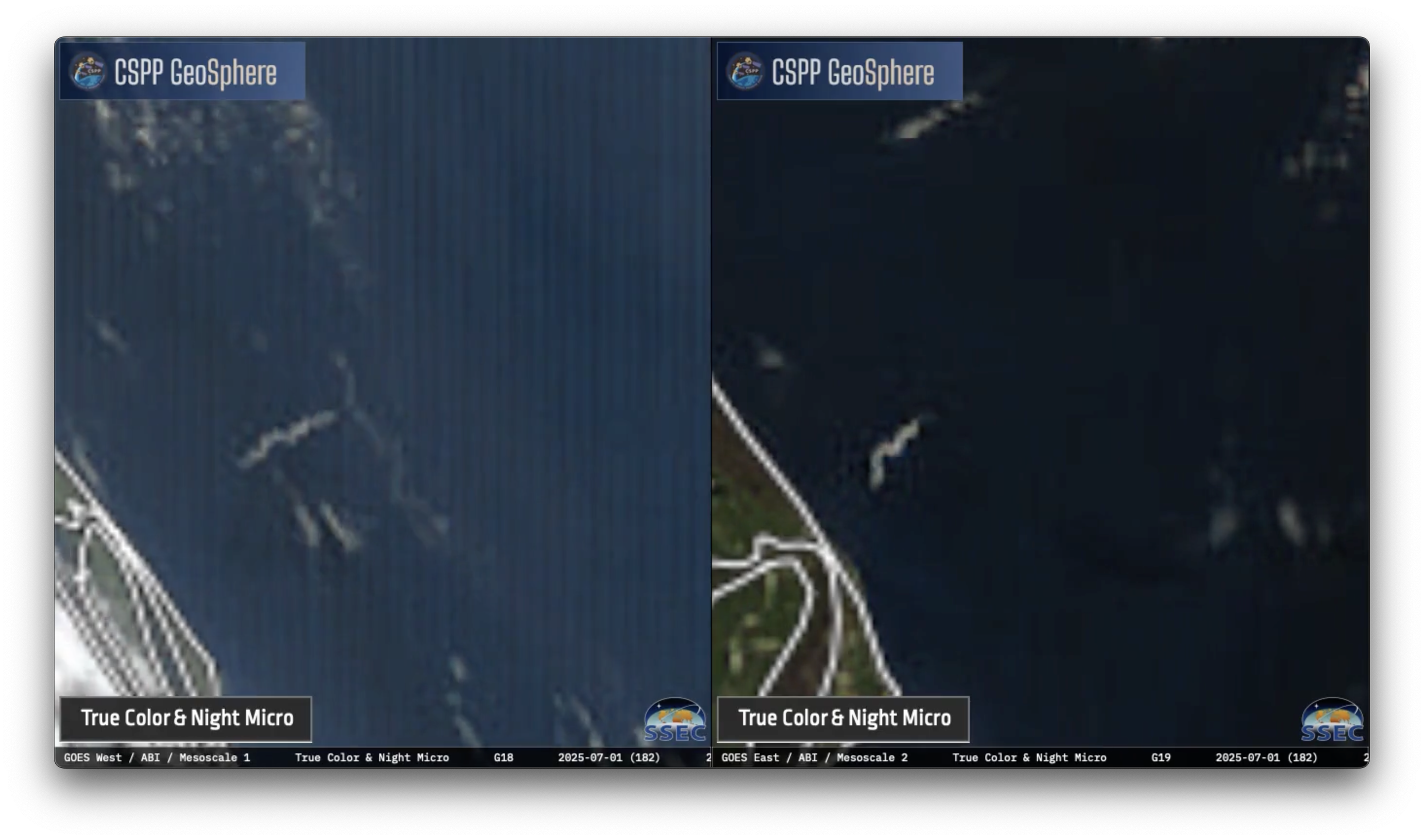
Figure: True Color RGB images frm GOES-18 (left) and GOES-19 (right), showing the SpaceX Falcon 9 rocket booster condensation cloud plume during the launch of EUMETSAT MTG-S1 from Kennedy Space Center in Florida on July 1, 2025.
PUBLICATIONS:
Estimating tropical cyclone intensity with 183 GHz microwave imagery paper accepted: Scientists at the Cooperative Institute for Meteorological Satellite Studies (CIMSS) had their paper titled "Estimating Current Tropical Cyclone Intensity from 183-GHz Microwave Satellite Observations using a Convolutional Neural Network" accepted for publication in Weather and Forecasting. This paper describes the Deep Multispectral INtensity of TCs estimator with 183GHz (D-MINT183), a convolutional neural network which estimates tropical cyclone intensity using 183-GHz microwave imagery, infrared imagery, and environmental scalar predictors. D-MINT183 is a companion to D-MINT, which uses 37- and 89-GHz imagery instead of 183-GHz microwave imagery and was found to be more skillful than infrared imagery and environmental scalar predictors alone. D-MINT183 now allows tropical cyclone intensity estimates in real-time from new satellites, including the Advanced Technology Microwave Sounder (ATMS), Time-Resolved Observations of Precipitation structure and storm Intensity with a Constellation of Smallsats (TROPICS), and most recently the Tomorrow.io Microwave Sensor (TMS). Given the recent news about the impending discontinuation of the information flow from the remaining DMSP SSMI satellites, this new D-MINT functionality comes at a critical time to support TC monitoring from space. (S. Griffin, CIMSS, 608-262-0986, T. Wimmers, CIMSS, C. Velden, CIMSS, D. Herndon, CIMSS, J. Hawkins, CIMSS)
 (Click image to enlarge)
Figure: D-MINT tropical cyclone intensity estimates without (left) and with (right) D-MINT183 estimates from Hurricane Erick (2025).
OTHER:
| Archived Weeklies Page | Submit a report item |