[ Archive ]
| CIMSS-NOAA Weekly Report [ Archive ] |
CIMSS-NOAA WEEKLY HIGHLIGHTS FOR THE WEEK ENDING JULY 11, 2025
DATA, INFORMATION, AND USE-INSPIRED SCIENCE:
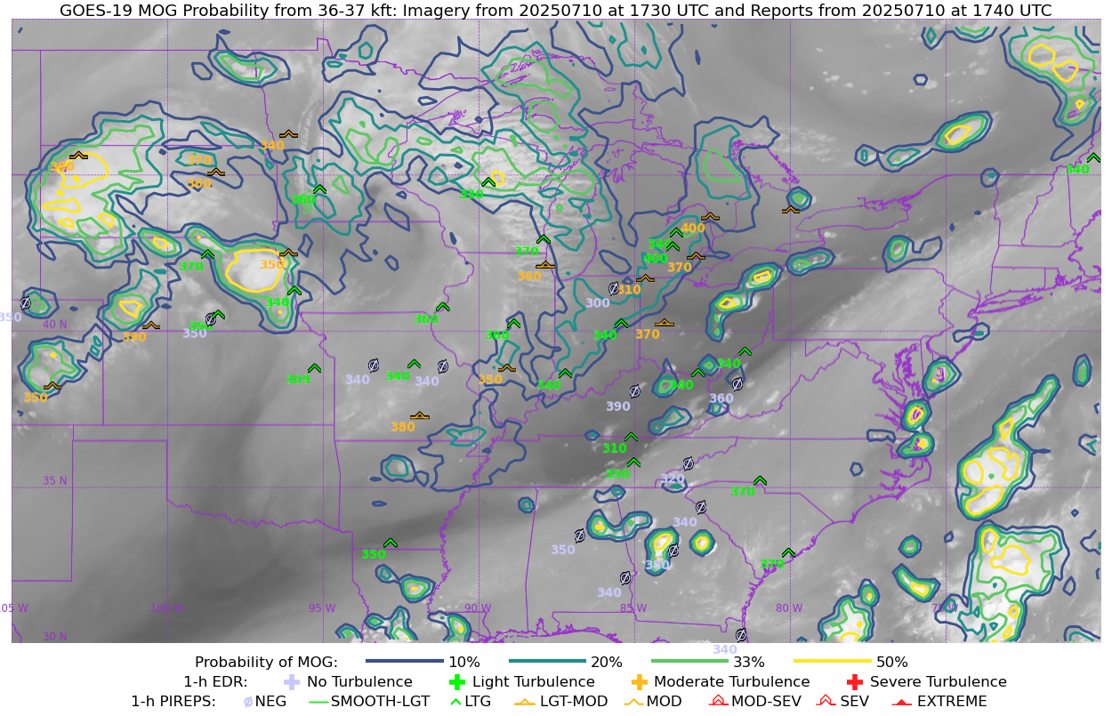
Delivery of the GOES Turbulence Product: On July 7, the Cooperative Institute for Meteorological Satellite Studies delivered Version 1.0.0 of the GOES Turbulence Product to ASSISTT at NOAA NESDIS for incorporation into operations as a Cloud Containerized Algorithm Package (CCAP) to be deployed in the NESDIS Common Cloud Facility (NCCF). The product is generated from a machine learning model trained on three years of automated, global observations of aircraft turbulence. Inputs include the GOES upper tropospheric water vapor channel, the infrared window channel, and GFS variables in the upper troposphere. Our sensitivity studies have shown that GOES imagery is more important than the GFS as an input, because of the ability of the GOES imagery to capture convection and major gravity waves, which are generally underrepresented in numerical models. (A. Wimmers, CIMSS, 608-263-3294)
 (Click image to enlarge)
Figure: Example of the turbulence product over the Central United States on Thursday, 10 July 2025. The underlying image is the GOES upper tropospheric water vapor channel (Ch 8). The contours are predicted probability of Moderate or Greater (‘MOG’) turbulence. Symbols are manual pilot reports of turbulence within two hours of the product time. The product accuracy is confirmed by the general colocation of high-probability contours and MOG reports (orange).
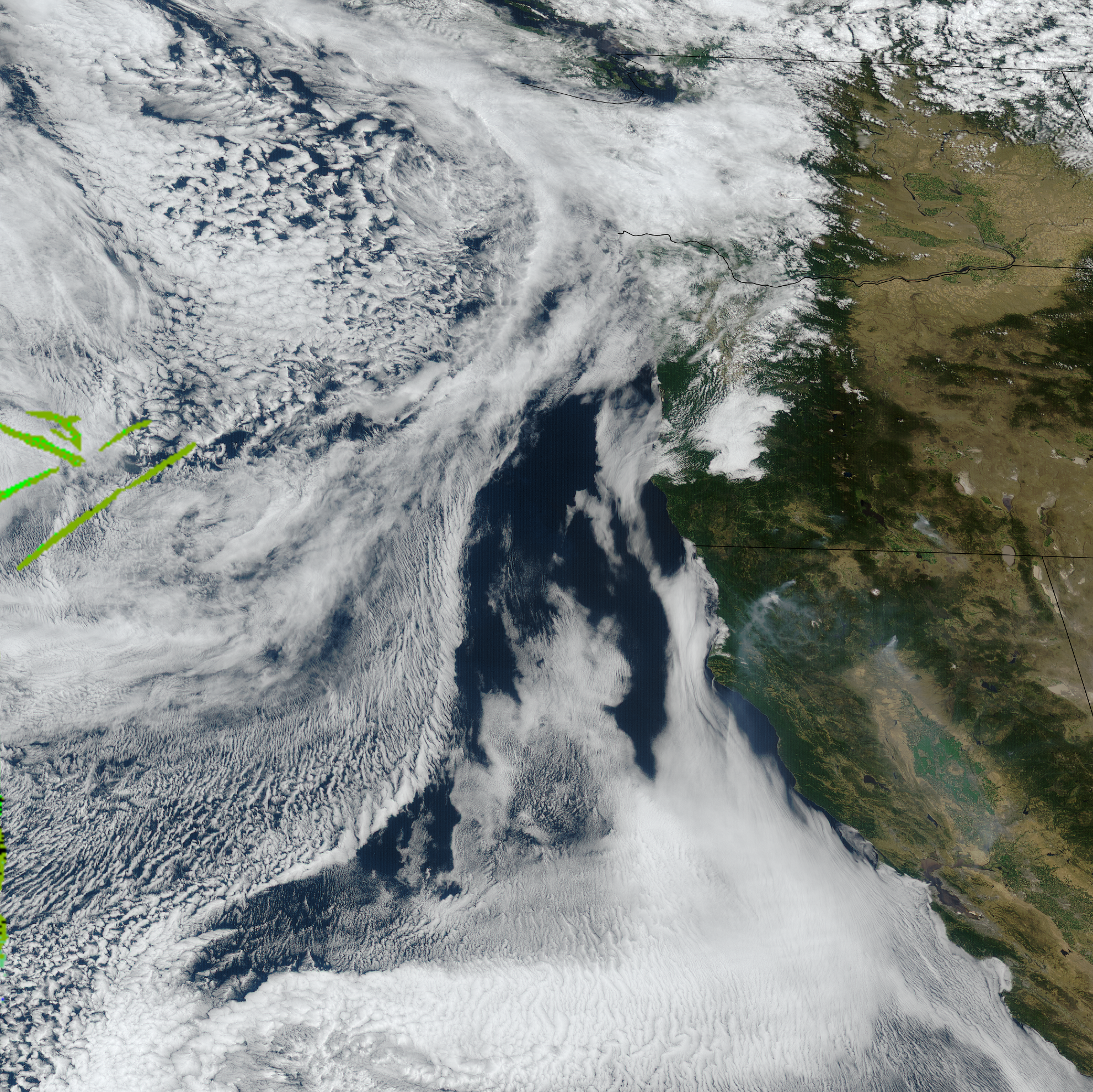
CIMSS Contrail Detection for Boeing/Honeywell Test Flights: This week, the Cooperative Institute for Meteorological Satellite Studies requested 1-minute mesoscale GOES ABI imagery in support of test flights conducted as part of a joint mission with The Boeing Company and Honeywell. A Honeywell aircraft was equipped with specialized sensors to sample atmospheric conditions. CIMSS researchers provided a contrail detection method, where contrail heights are derived by applying the ABI Cloud Height Algorithm (ACHA) at detected contrail locations. (J. Hoffman, CIMSS, 608-890-1690, M. Gunshor, CIMSS, 608-263-1146, W. Feltz, CIMSS, 608-265-6283, T. Wimmers, CIMSS, 608-263-3294, T. Wagner, CIMSS, 608-890-1980, M. Foster, CIMSS, 608-261-1361)
 (Click image to enlarge)
Figure: GOES-West mesoscale natural color imagery at 17:59 UTC on July 10, 2025. Contrail detections are highlighted in shades of green, indicating altitudes between 34,000 and 40,000 feet above sea level.
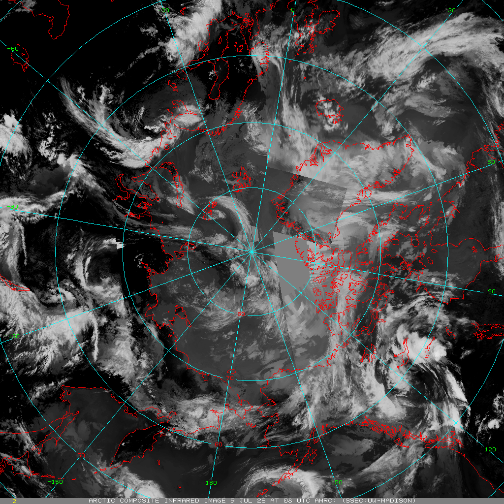
New Server for CIMSS Arctic Composite Imagery Project: The Arctic Composite Imagery (ACI) Project at the Cooperative Institute for Meteorological Satellite Studies (CIMSS) has successfully transferred product generation and distribution to a new server. This server will ensure ACI output continue to be made and distributed on a reliable, routine basis. These imagery are hourly, real-time (with ~3 hour delay) satellite composite imagery centered over the North Pole. Five channels of imagery are created: infrared (center wavelength ~11.0 micrometers), longwave (~12.0 microns), shortwave (~3.8 micrometers), visible (~0.65 micrometers), and water vapor (~6.7 micrometers). (D. Mikolajczyk, CIMSS, 608-262-0780)
 (Click image to enlarge)
Figure: Infrared Arctic satellite composite image, 08 UTC 09 July 2025.
PEOPLE, AWARDS AND RECOGNITION:
TRAVEL AND MEETINGS:
TRAINING AND EDUCATION:
MEDIA INTERACTIONS AND REQUESTS:
SOCIAL MEDIA AND BLOG POSTS:
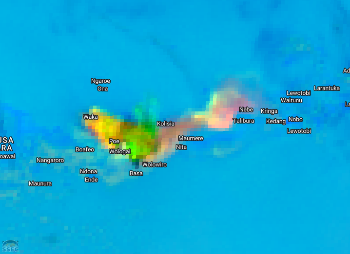
CIMSS Satellite Blog Updates: The Cooperative Institute for Meteorological Satellite Studies (CIMSS) Satellite Blog (https://cimss.ssec.wisc.edu/satellite-blog/) was updated with the following posts: "Catastrophic flash flooding event in the Hill Country of Texas responsible for at least 120 fatalities" (Jul. 4), "Indonesian Volcano Mount Lewotobi Laki-laki Erupts Multiple Times" (Jul. 8), "Deadly flash flooding in Ruidoso, New Mexico" (Jul. 8), "American Samoa’s Wettest Year Gets Wetter" (Jul. 10) and "Wildfire in Ontario produces a large pyrocumulonimbus cloud" (Jul. 10). (S. Bachmeier, 608-263-3958, T. Wagner, 608-890-1980, CIMSS)
 (Click image to enlarge)
Figure: GOES-19 Infrared image at 0611 UTC on July 4 2025, showing thunderstorms that produced catastrophic flash flooding in the Hill Country of Texas -- resulting in over 120 fatalities.
 (Click image to enlarge)
Figure: Himawari-9 Ash RGB image at 0420 UTC on July 7 2025, showing the volcanic cloud following an eruption of Mount Lewotobi Laki-laki in Indonesia.
PUBLICATIONS:
OTHER:
| Archived Weeklies Page | Submit a report item |