[ Archive ]
| CIMSS-NOAA Weekly Report [ Archive ] |
CIMSS-NOAA WEEKLY HIGHLIGHTS FOR THE WEEK ENDING MARCH 14, 2025
DATA, INFORMATION, AND USE-INSPIRED SCIENCE:
FUTURE OUTLOOK:
AWARDS AND RECOGNITION:
TRAVEL AND MEETINGS:
CIMSS participation in WMO Workshop on Satellite Observations for Hydrology: The World Meteorological Organization (WMO) organized an online "Workshop on Deep-dive on Satellite Observations for Hydrology" in order to strengthen the use of hydrological satellite data to complement in-situ observations, which took place 13-14 March 2025. The objectives of the workshop were to: 1) To identify satellite-based hydrological observations that contribute to improving performance and quality of hydrological modelling, forecasting, and monitoring, long-term monitoring and other applications; 2) To showcase the successes in observations and uses of hydrological satellite data satellite and associated social economic benefit; 3) To explore the existing satellite data used in hydrology and space agencies’ policies with focus on core and recommended hydrological satellite data; and 4) To inform of the new and prospective satellite missions and instruments of relevance. There were presentations from a variety of institutions, ranging from the use of Surface Water Ocean Topography (SWOT), soil moisture as well as use cases of satellite data for hydrology. William Straka (Cooperative Institute for Meteorological Satellite Studies, CIMSS) was asked by WMO to give the keynote presentation on the "An Overview Satellite observation for hydrology" for the first day, providing a brief overview on how satellite observations can be used in the hydrological cycle. This workshop is the first of many to help develop the needs of the hydrological community and how satellites can help fufill those needs. (W. Straka III, CIMSS)
TRAINING AND EDUCATION:
MEDIA INTERACTIONS AND REQUESTS:
SOCIAL MEDIA AND BLOG Posts:
CIMSS Satellite Blog Updates: The Cooperative Institute for Meteorological Satellite Studies (CIMSS) Satellite Blog was updated with the following posts: "Satellite signatures of the Starship Test Flight 8 launch" (Mar. 6), "High winds prevent a Hawaiian Airlines flight to Pago Pago from landing" (Mar. 10), "NGFS detections of a small marsh fire in Brookfield WI" (Mar. 10), "When upper air soundings are missing: NUCAPS can help" (Mar. 11), "Ice leads in the eastern Beaufort Sea" (Mar. 11) "Blowing dust across Texas" (Mar. 12) and "Nighttime Tornado in Los Angeles" (Mar. 13). (S. Bachmeier, S. Lindstrom, T. Wagner, CIMSS, 608.263.4425)
 (Click image to enlarge)
Figure: Suomi-NPP VIIRS Visible image at 2143 UTC on March 10, showing ice leads in the eastern Beaufort Sea in addition to a polynya near the coast in the vicinity of the Alaska/Yukon border.
PUBLICATIONS:
Review Article on Satellite Applications to Tropical Cyclones Accepted: An invited article was recently accepted in the Journal of the European Meteorological Society. The paper, titled "Recent Innovations in Satellite-Based Applications and their Impacts on Tropical Cyclone Analyses and Forecasts" by C. Velden, J. Knaff, D. Herndon, J. Hawkins et al., is a review article that chronicles recent satellite-based products and innovations toward improving the analysis of global tropical cyclones. 'Medicanes' are also briefly highlighted, as these storms which occur over the Mediterranean Sea can have many characteristics of tropical cyclones and result in highly impactful European weather events. The article presents an overview of some of the recent advances in meteorological satellite capabilities (LEO and GEO) to observe tropical cyclones and Medicanes, along with emerging techniques to analyze the data into TC-focused diagnostic products. Contributions by NOAA/NESDIS and cooperative research institutes CIMSS and CIRA figure prominently. (C. Velden, CIMSS; J. Knaff, NOAA/STAR/CIRA; D. Herndon and J. Hawkins, CIMSS)
 (Click image to enlarge)
Figure: View of Medicane Ianos from a NOAA-20 ATMS overpass at 11:39 UTC 17 Sept. 2020. Planar Tb views from the sounder thermal channels 7-9 are shown on the left. A longitudinal cross-section of Tb anomaly (deg. C) through the center of Ianos shows the warm-core structure similar to tropical cyclones. The 183 GHz (channel 18) shows a ring of deep convection around the center of Ianos similar to an eyewall. [Credit: CIMSS]
 (Click image to enlarge)
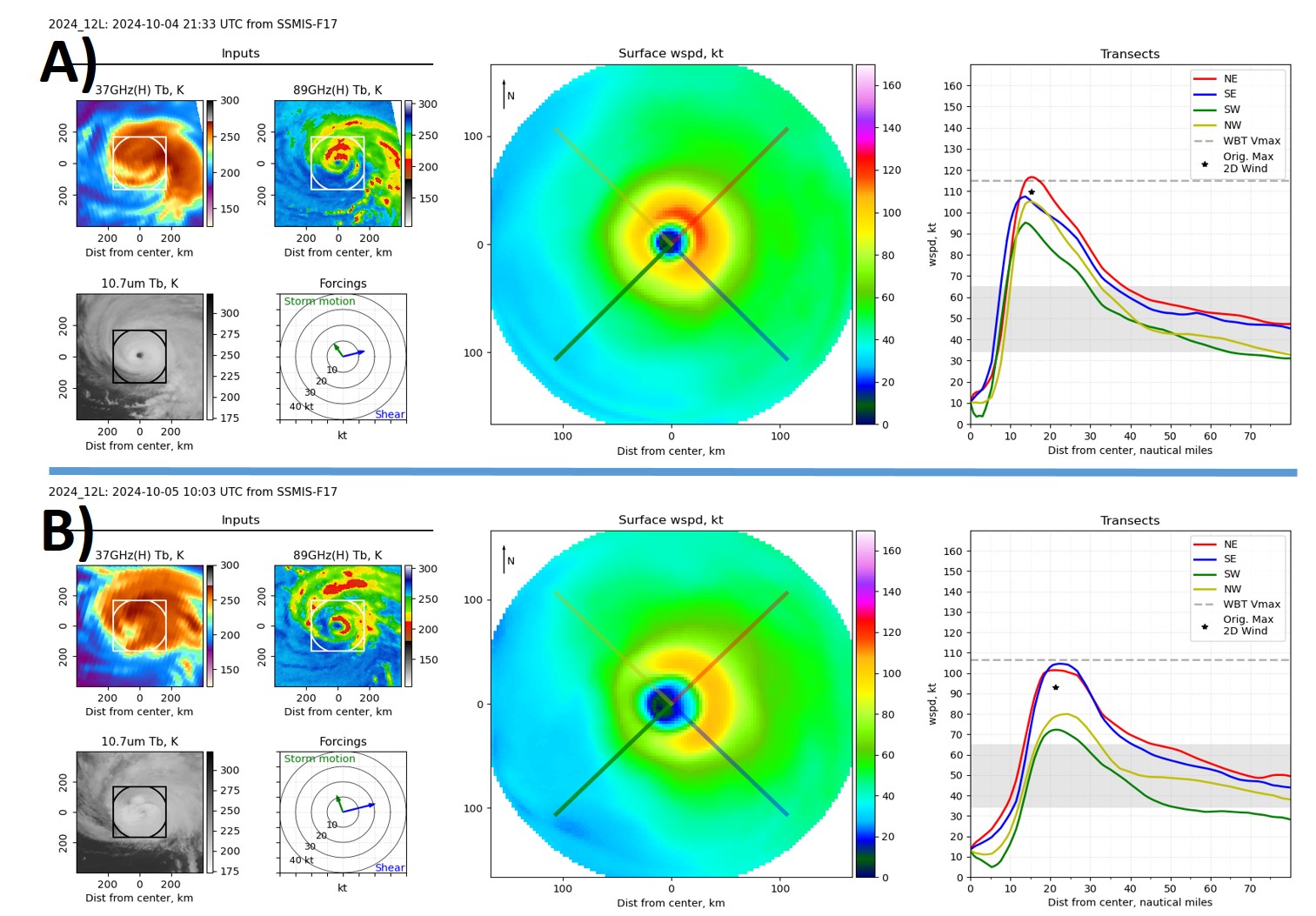
Figure: Hurricane Kirk inner-core surface wind fields produced from the deep learning method of Wimmers et al., 2024; https://doi.org/10.1175/AIES-D-23-0084.1, for A) 2133 UTC on 4 Oct., and B) 1003 UTC on 5 Oct. 2024. Input data (left panels) consists of SSMIS 37 and 89 GHz Tb, and 10.7 μm Tb from GOES-16, along with estimates of storm motion and environmental shear. The middle panels show the color-coded (by wind speed, in kts) 2-D surface wind field. The right-hand panels depict the horizontal radial wind profiles along the 4 quadrant transects depicted in the middle panels, along with the model and NHC working best track (WBT) maximum surface wind estimates. [Credit: A. Wimmers, CIMSS]
OTHER:
| Archived Weeklies Page | Submit a report item |