[ Archive ]
| CIMSS-NOAA Weekly Report [ Archive ] |
CIMSS-NOAA WEEKLY HIGHLIGHTS FOR THE WEEK ENDING MARCH 21, 2025
DATA, INFORMATION, AND USE-INSPIRED SCIENCE:
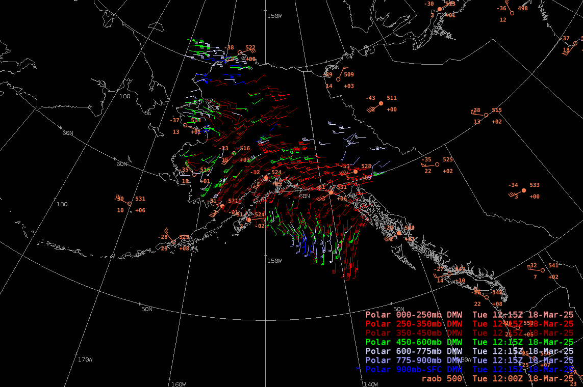
Direct Broadcast VIIRS Winds Now Available in AWIPS at NWS Alaska: During discussions at the September 2024 Alaska Next Generation Workshop in Anchorage, Alaska, the idea of making Direct Broadcast (DB) winds from JPSS VIIRS available to NWS in Alaska was agreed upon. This was spearheaded by Carl Dierking at University of Alaska-Fairbanks Geographic Information Network of Alaska (UAF-GINA) and Richard Dworak at University of Wisconsin-Madison Cooperative Institute for Meteorological Satellite Studies (CIMSS). With only 13 weather balloon stations in Alaska launching weather balloons twice a day, which is insufficient for such a large area. Currently, VIIRS satellite data from Gilmore Creek, Alaska GINA DB antenna is sent directly to CIMSS to be processed in creating cloud tracking Atmospheric Motion Vectors (AMVs) from VIIRS on S-NPP, NOAA-20, and NOAA-21 satellites using the Enterprise framework. Output BUFR files are sent back to GINA, where they are immediately read into AWIPS to be displayed at NWS Alaska regional offices. An example of the AWIPS display of VIIRS AMVs from 12:15 UTC on 18 March 2025 with associated 500 hPa RAOB observations in the figure below shows enhanced coverage with VIIRS AMVs included. (R. Dworak, 608-265-8620)
 (Click image to enlarge)
Figure: AWIPS display of both VIIRS AMVs and 500 hPa RAOB (beige color) wind observations. The color key for vertical layers is given in lower right.
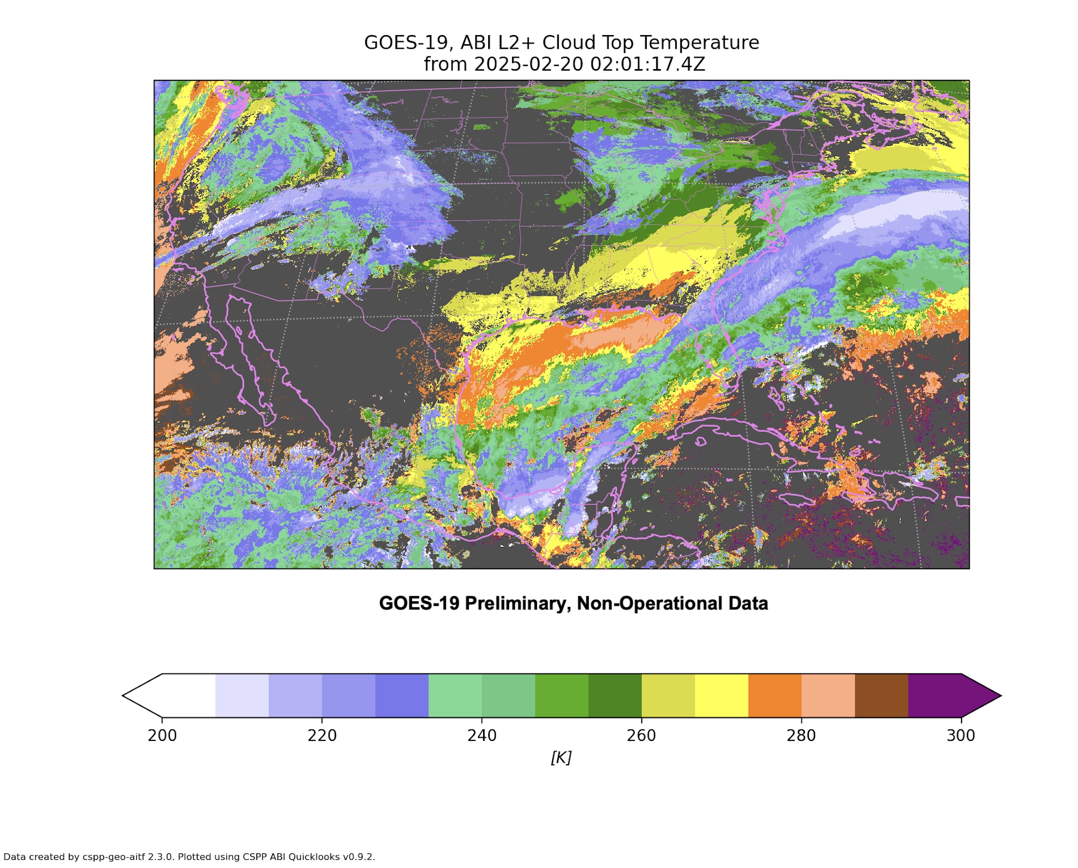
GOES-19 fully supported in CSPP Geo software: The Community Satellite Processing Package for Geostationary Data (CSPP Geo) group at the Cooperative Institute for Meteorological Satellite Studies (CIMSS) has released a new version of the AIT Framework software, which retrieves atmospheric and surface parameters using data from the GOES-R series of satellites. The v2.3.0 release will allow users to process data from the GOES-19 satellite, set to become operational on April 4, 2025. Additional new features include updated science algorithms and added products for GOES-17 and GOES-18. The AIT Framework package utilizes NOAA enterprise product algorithms, developed by CIMSS and other institutions, within a processing system developed by the ASSISTT group at NOAA NESDIS. With this release GOES-19 is fully supported in the CSPP Geo software suite. Over the coming weeks, the CSPP Geo team will provide technical support to users as they prepare for and begin processing data from GOES-19. (G. Martin, CIMSS)
 (Click image to enlarge)
Figure: An example CSPP Geo AIT Framework software product: GOES-19 Cloud Top Temperature. The image was generated with a built-in “quicklooks” plotting capability.
FUTURE OUTLOOK:
AWARDS AND RECOGNITION:
TRAVEL AND MEETINGS:
TRAINING AND EDUCATION:
VISIT Training for WFO EKA on GOES-R IFR Probability fields: Scott Lindstrom from the Cooperative Institute for Meteorological Satellite Studies (CIMSS) presented a Virtual Institute for Satellite Integration Training (VISIT) telecon on GOES-R IFR Probability Fields to the forecast office in Eureka CA (WFO EKA). The training was to the Science and Operations Officer (SOO) and to a Meteorologist in the office. It was followed by a Q&A session. (S. Lindstrom, CIMSS, 608 263 4425)
MEDIA INTERACTIONS AND REQUESTS:
SOCIAL MEDIA AND BLOG Posts:
CIMSS Satellite Blog entries for this week: Each week, scientists at the Cooperative Institute for Meteorological Satellite Studies (CIMSS) compile short blog posts that highlight the utility and beauty of Satellite data and imagery. This week's posts include: Cyclone spin-up over Samoa on 9 March 2025, Lunar eclipse effects on the Day Night Band, Early morning rumblers, GOES-16 views the Space-X launch, Numerous wildfires in Oklahoma, and widespread blowing dust across the southern Plains, NGFS detection of multiple warned fires over Oklahoma, Resuspended ash from the 1912 Navarupta-Katmai eruption, Wild weather weekend, Another dusty storm in the Midwest, Day Cloud Phase Distinction and snow bands. (S. Bachmeier, S. Lindstrom, CIMSS, 608 263 4425; J. Cintineo NOAA/OAR)
.png) (Click image to enlarge)
(Click image to enlarge)
Figure: Real Earth instance of NGFS detections over Oklahoma showing multiple fire detections at 2336 UTC on 14 March 2025.
PUBLICATIONS:
OTHER:
| Archived Weeklies Page | Submit a report item |