[ Archive ]
| CIMSS-NOAA Weekly Report [ Archive ] |
CIMSS-NOAA WEEKLY HIGHLIGHTS FOR THE WEEK ENDING SEPTEMBER 5, 2025
DATA, INFORMATION, AND USE-INSPIRED SCIENCE:
CIMSS Releases a CSPP Geo AIT Framework Software Update: The Community Satellite Processing Package for Geostationary Data (CSPP Geo) group at the Cooperative Institute for Meteorological Satellite Studies (CIMSS) has released a patch update to the AIT Framework software package. The v2.3.1 release improves the GOES-19 Aerosol Optical Depth product over land and updates the Cloud Mask product to the latest NOAA version. The AIT Framework package allows users to generate geophysical products for use in near real-time applications by processing Advanced Baseline Imager data received directly from the GOES-16, GOES-17, GOES-18 and GOES-19 satellites. The basis of the software package is NOAA enterprise product algorithms that were developed at CIMSS and other institutions, running in a processing framework that is maintained by the ASSISTT group at NOAA NESDIS. (G. Martin, CIMSS)
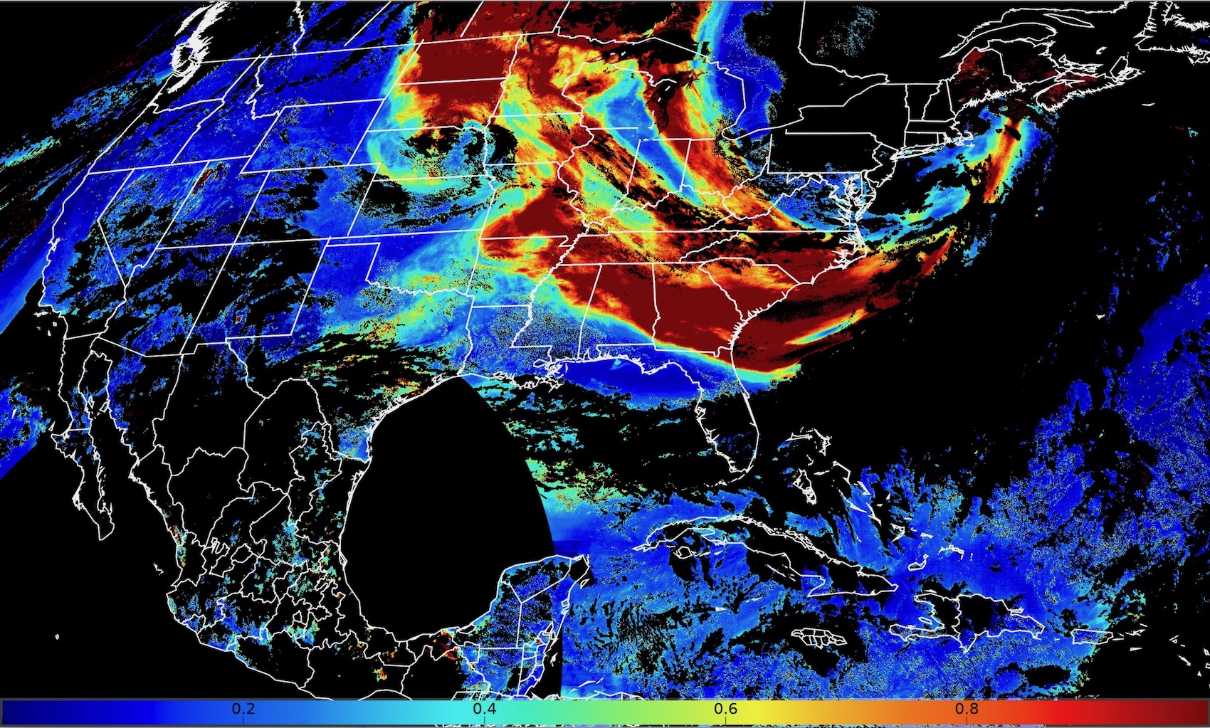 (Click image to enlarge)
Figure: GOES-19 Aerosol Optical Depth product generated by CSPP Geo AIT Framework v2.3.1 and plotted using the CSPP Geo Geo2Grid package, showing smoke from Canadian wildfires on 31 May 2025.
PEOPLE, AWARDS AND RECOGNITION:
TRAVEL AND MEETINGS:
TRAINING AND EDUCATION:
MEDIA INTERACTIONS AND REQUESTS:
SOCIAL MEDIA AND BLOG Posts:
CIMSS Satellite Blog Updates: The Cooperative Institute for Meteorological Satellite Studies (CIMSS) Satellite Blog (https://cimss.ssec.wisc.edu/satellite-blog/) was updated with the following posts: "Wildfires rage in Pacific Northwest" (Sep. 3) and "Hurricane Kiko rapidly intensifies to a Category 4 storm in the East Pacific Ocean" (Sep. 3). (S. Bachmeier, T. Wagner, CIMSS, 608-890-1980)
 (Click image to enlarge)
Figure: GOES-18 True Color RGB image at 1916 UTC on September 3, 2025 -- showing dense smoke across much of the Pacific Northwest, produced by numerous wildfires that were burning across the region.
 (Click image to enlarge)
Figure: GOES-18 Visible and Infrared images at 2300 UTC on September 3, 2025 -- showing the eye and eyewall of Category 4 Hurricane Kiko ovver the East Pacific Ocean.
PUBLICATIONS:
CIMSS paper on the assimilation of radiance tendency observations from geostationary satellites published: A manuscript titled "Assimilation of radiance tendency observations from geostationary satellites in NCEP's Global Forecast System" was published in Quarterly Journal of the Royal Meteorological Society. This study introduces radiance tendency assimilation, which uses temporal changes in geostationary radiances to reduce sensitivity to persistent biases, such as surface emissivity errors. Experiments with Advanced Baseline Imager (ABI) and Advanced Himawari Imager (AHI) data showed that water-vapor-band assimilation increased moisture-related biases, while non-water-vapor bands provided stable analyses. Higher spatial density improved near-surface forecasts over ocean, though limitations in the uncoupled system prevented consistent boundary layer adjustments. The citation is Lim A. H. N., Z. Li, S. E. Nebuda and J. A. Jung, (2025): Assimilation of radiance tendency observations from geostationary satellites in NCEP’s Global Forecast System, Quarterly Journal of the Royal Meteorological Society, e70005. Available from: https://doi.org/10.1002/qj.70005. This work was supported by the NOAA GOES-R Risk Reduction Program.(A. Lim, CIMSS, 608-265-8620)
OTHER:
| Archived Weeklies Page | Submit a report item |