[ Archive ]
| CIMSS-NOAA Weekly Report [ Archive ] |
CIMSS-NOAA WEEKLY HIGHLIGHTS FOR THE WEEK ENDING SEPTEMBER 12, 2025
DATA, INFORMATION, AND USE-INSPIRED SCIENCE:
PEOPLE, AWARDS AND RECOGNITION:
TRAVEL AND MEETINGS:
TRAINING AND EDUCATION:
MEDIA INTERACTIONS AND REQUESTS:
SOCIAL MEDIA AND BLOG Posts:
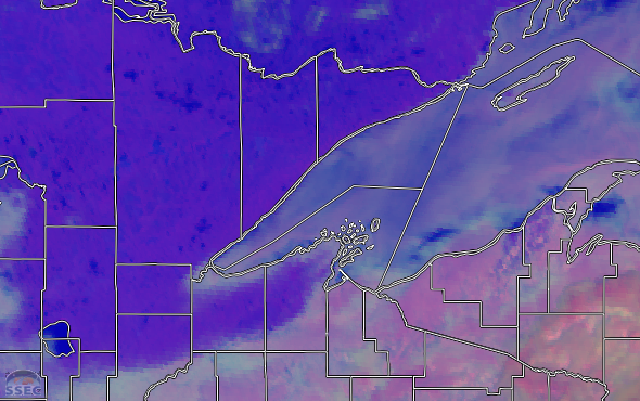
CIMSS Satellite Blog Updates: The Cooperative Institute for Meteorological Satellite Studies (CIMSS) Satellite Blog (https://cimss.ssec.wisc.edu/satellite-blog/) was updated with the following posts: "Lightning causes a delay during the Eagles vs Cowboys football game" (Sep. 4), "Effects of a lunar eclipse on GOES-18/GOES-19 SUVI imagery" (Sep. 7), "Severe thunderstorms produce giant hail and isolated tornadoes in the Southern Plains" (Sep. 8), "A Foggy Morning for Lake Superior" (Sep. 10) and "Post-Tropical Cyclone Kiko north of Hawai’i" (Sep. 10) . (S. Bachmeier, T. Wagner, CIMSS, 608-890-1980)
 (Click image to enlarge)
Figure: GOES-19 Day Microphysics RGB image at 1636 UTC on September 10, 2025 -- showing the extent of fog (pale shades of gray) across much of western Lake Superior.
 (Click image to enlarge)
Figure: GOES-19 “Red” Visible (0.64 µm, left) and “Clean” Infrared Window (10.3 µm, right) images with time-matched SPC Storm Reports plotted in red/cyan at 2215 UTC on September 8, 2025 -- showing a supercell thunderstorm that was producing hail of 4.00 inches in diameter (H400) over southwest Kansas.
PUBLICATIONS:
OTHER:
| Archived Weeklies Page | Submit a report item |