[ Archive ]
| CIMSS-NOAA Weekly Report [ Archive ] |
CIMSS-NOAA WEEKLY HIGHLIGHTS FOR THE WEEK ENDING NOVEMBER 7, 2025
DATA, INFORMATION, AND USE-INSPIRED SCIENCE:
GOES Sky Cover Algorithm/Operational Readiness Review: The Cooperative Institute for Meteorological Satellite Studies has been producing the GOES Sky Cover product for the National Centers for Environmental Prediction (NCEP) Real-Time Mesoscale Analysis (RTM) and the Unrestricted Mesoscale Analysis (URMA) since April 2015. The baseline Sky Cover product used a blend of McIDAS-X Fortran to ingest locally produced NOAA Enterprise cloud products from the Clouds from AVHRR Extended (CLAVR-x) processing Framework. The baseline code has been rewritten with a blend of Python and Fortran 90 (Ray Garcia/Jim Nelson) and delivered to NOAA. CIMSS continues to supply Sky Cover to NCEP with this version of the software. An Algorithm/Operational Readiness Review was scheduled for November 5, but due to the Federal government shutdown the review has turned into an online slide deck review. CIMSS provided the Algorithm Validation content. The NOAA produced Sky Cover is tentatively scheduled to go live on November 15. (S. Wanzong, CIMSS, 608-215-6752, A. Heidinger, E/RA2, 608-263-6757, W. Straka III, CIMSS, R. Garcia, SSEC, 608-262-8439)
PEOPLE, AWARDS AND RECOGNITION:
TRAVEL AND MEETINGS:
TRAINING AND EDUCATION:
MEDIA INTERACTIONS AND REQUESTS:
SOCIAL MEDIA AND BLOG Posts:
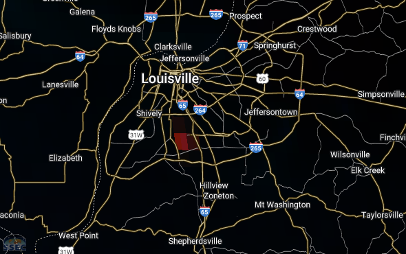
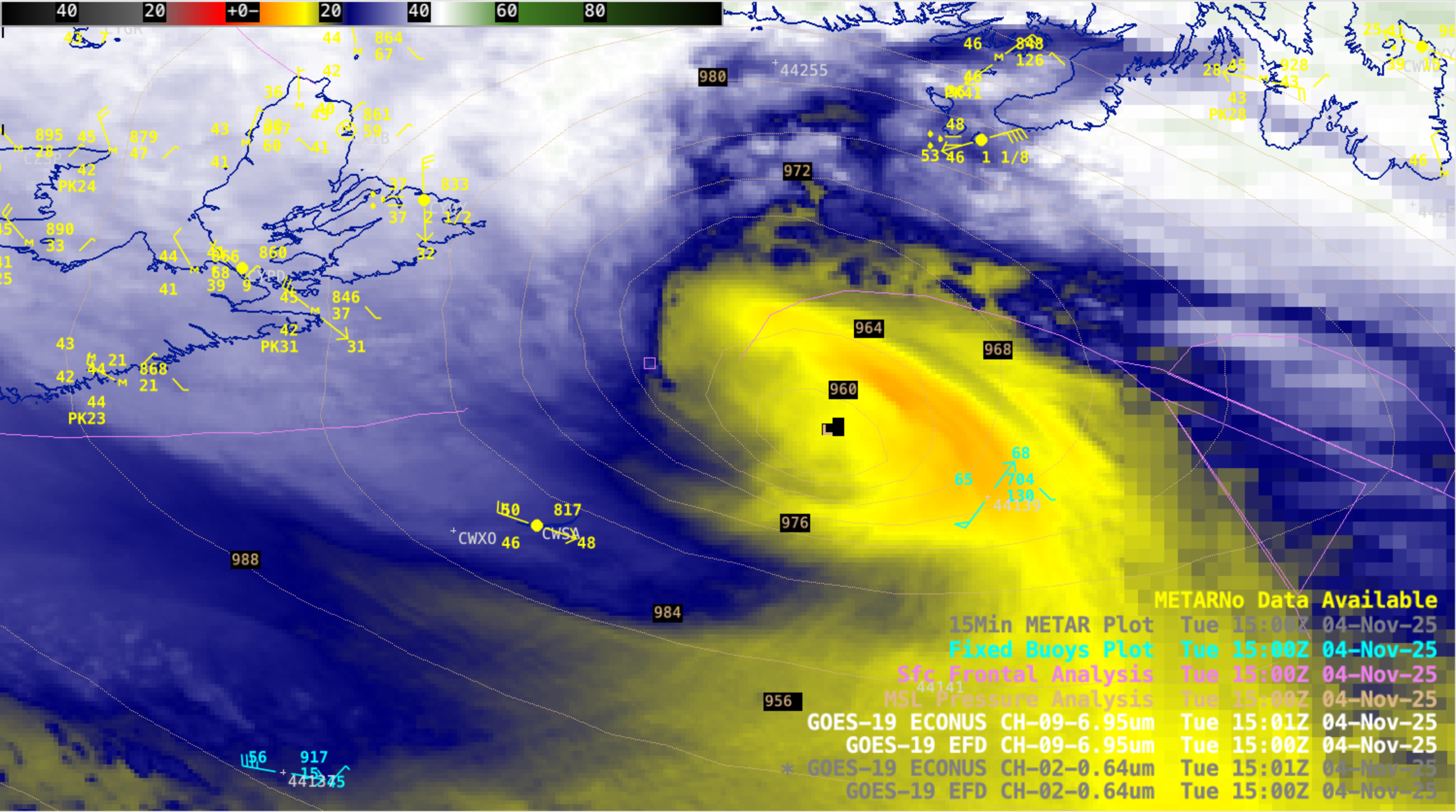
CIMSS Satellite Blog Updates: The Cooperative Institute for Meteorological Satellite Studies (CIMSS) Satellite Blog (https://cimss.ssec.wisc.edu/satellite-blog/) was updated with the following posts: "Rapidly intensifying Hurricane Force Low south of Atlantic Canada" (Nov. 4) and "GOES Views of the UPS Flight 2976 Crash in Louisville" (Nov. 5). (S. Bachmeier, T. Wagner, CIMSS, 608-890-1980)
 (Click image to enlarge)
Figure: GOES-19 Fire Temperature RGB image at 2220 UTC on Nov. 4, 2025 -- showing the thermal signature of a fire associated with the crash of UPS Flight 2976 at the Louisville, Kentucky International Airport.
 (Click image to enlarge)
Figure: GOES-19 Water Vapor image at 1501 UTC on Nov. 4, 2025 -- showing a rapidly intensifying Hurricane Force Low south of Atlantic Canada.
PUBLICATIONS:
CIMSS paper on the assimilation of shortwave infrared radiances published in the Quarterly Journal of the Royal Meteorological Society: This is the second part of a two-part manuscript entitled “Exploration of the use of short-wave infrared radiances in weather forecasts model.” Part I was published in June 2025. Part II tested the methodology developed in Part I within a data assimilation framework to enable the use of short-wave infrared (SWIR) radiances. Overall, assimilating SWIR radiances did not degrade existing observations and no significant temperature biases were found at SWIR-sensitive levels. In addition, including SWIR data improved forecasts, enhancing 250 hPa and 500 hPa geopotential height correlations and reducing temperature root mean square error beyond 48 hours (from 50 hPa to the surface). The assimilation of day and night SWIR observations separately performed better than combining them. The citation is Lim A. H. N., Z. Li, D. Di and J. A. Jung, (2025): Exploration of the use of short-wave infrared radiances in weather forecasts model Part II: Data assimilation and forecast impact assessment, Quarterly Journal of the Royal Meteorological Society, e70057 Available from: https://doi.org/10.1002/qj.70057. This work was supported by the NOAA Joint Polar Satellite System Proving Ground and Risk Reduction Program. (A. Lim, CIMSS, 608-265-8620)
OTHER:
| Archived Weeklies Page | Submit a report item |