Atmospheric humidity
The observations for atmospheric humidity are a core requirement for weather forecasting and are largely dealt with in the framework of the Coordinating Group for Meteorological Satellites (CGMS). A wide range of sensors are available and these are improved as technology allows. In broad terms the challenges are to improve vertical resolution of observations, overcome cloud problems and improve the ability to process sounding data over land.
The 3 dimensional field of humidity is a key variable for global weather prediction (NWP) models that are used to produce short- and medium-range forecasts of the state of the troposphere and lower stratosphere. Polar satellites provide information on tropospheric humidity with global coverage, good horizontal resolution and acceptable accuracy, but with poor vertical resolution.
In the case of observations for regional NWP models, polar and geostationary satellites provide estimates of total column water vapour accurate to within 10-20%. Enough information is collected to infer moisture concentration within several thick layers vertically, with good horizontal resolution. Vertical resolution is marginal for mesoscale prediction, and the infrared information is available only for cloud-free fields of view.
Until recently, performance in cloudy areas was poor, but the new microwave measurements from AMSU offer substantial improvements. Geostationary infrared soundings are also helping to expand coverage in some regions by making measurements on repeat timescales of fifteen minutes to one hour and thus creating more
cloud-free observations. Over oceans, coverage is currently supplemented by information on total column water vapour from microwave imagers.
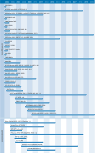
Humidity measurements for weather forecasting are assured continuity through the operations of the METOP, NOAA, and NPOESS series, which in future will feature instruments with improved accuracy and resolution, a number of which will be common to the different satellites (such as AMSU-A, HIRS/4, and MHS). The DMSP series sounders will also provide continuity. NPOESS will feature the combination of the CRiS interferometer and ATMS sounder to derive accurate humidity profiles. This data will be supplemented by instruments on Aqua (AIRS+, AMSR-E, AMSU-A), Aura (HiRDLS, MLS, TES), and the FY-3 series (MWHS), amongst others.
Satellite sounding data are currently under-utilised over land, but progress in data interpretation is expected in the near future. Radio-occultation measurements using the GPS constellation is complementing other systems by providing information on the humidity profile in the lower troposphere.

