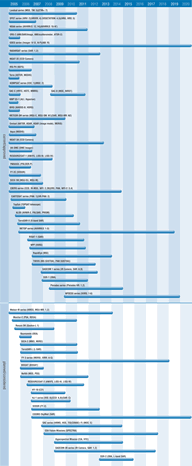
Multi-purpose imagery (land)
The spatial information which can be derived from satellite imagery is of value in a wide range of applications - particularly when combined with spectral information from multiple bands of a sensor. Satellite Earth observation is of particular value where conventional data collection techniques are difficult, such as in areas of inaccessible terrain, and can provide cost and time savings in data acquisition - particularly over large areas.
At regional and global scales, low resolution instruments with wide coverage capability and imaging sensors on geostationary satellites are routinely exploited for their ability to provide global scale data on land cover and vegetation. Land cover change detection is an important source of global environmental change and has profound implications for ecosystems, biochemical fluxes and climate. Instruments on satellites with wide and frequent coverage provide data useful for spin-off applications. AVHRR on NOAA’s polar orbiting satellite series was originally intended only as a meteorological satellite system, but has subsequently been used in a multitude of diverse applications.
On national and local scales, the higher spatial resolution requirements for information mean that high resolution imaging sensors, such as on SPOT, Landsat, and IRS series, and imaging radars - such as on ERS, Envisat and RADARSAT, are most useful. Such sensors are routinely used as practical sources of information for:
- agriculture: monitoring, precision farming and production forecasting;
- resource exploration and management eg forestry;
- geological surveying: mineral exploration and identification;
- hydrological applications: such as flood monitoring;
- civil mapping and planning: cartography, infrastructure and urban management;
- coastal zone monitoring including oil spill detection and monitoring;
- topographic mapping, generation of DEMs.
SAR data are particularly useful in monitoring and mapping floods because they are available even in the presence of thick cloud cover. Instruments of RADARSAT, Envisat and (from 2005) ALOS, continue to provide improved capabilities in this field. Such multi-incidence, high resolution SAR systems will also be useful for landslide inventory maps and earthquake mitigation. Moreover InSAR techniques can be used to document deformation and topographic changes preceding, and caused by, volcanic eruptions. Volcanic features have distinctive thermal characteristics which can be detected by thermal imagery, such as that provided by the ASTER radiometer flying on Terra. The IGOS Geo-hazards Theme report is the definitive reference on the value of satellite Earth observation for such applications. Future SAR instruments will continue to be important for land imagery because of their all weather day and night observing capability and high spatial resolution (1-3 metres) such as will be provided by Radarsat-2, COSMO-SKYMED and TerraSAR-X.
Higher performance radiometers such as AVNIR-2 and PRISM on ALOS will enhance land observing technology and provide improved data products. In general, future sensors will benefit from a greater number of sampling channels. NOAA’s VIIRS instrument for instance will have multi-channel imaging capabilities and will combine the radiometric accuracy of AVHRR with the high spatial resolution of the OLS flown on DMSP missions.

