Surface temperature (ocean)
Ocean surface temperature (often known as ‘sea surface temperature’, SST) is one of the most important boundary conditions for the general circulation of the atmosphere. The ocean exchanges vast amounts of heat and energy with the atmosphere and these air/sea interactions have a profound influence on the Earth’s weather and climate patterns. SST is also very sensitive to changes in ocean circulation, as demonstrated time and again by the El Niño-Southern Oscillation (ENSO) cycle. A major research goal is the development of an increased understanding of the links between SST and all the above processes. This will only be achieved through a more precise and comprehensive set of SST measurements.
Satellite remote sensing provides the only practical means of developing such a dataset. In-situ data, predominantly from ships of opportunity and from networks of moored and drifting buoys are limited in coverage whereas satellites offer the potential for surveying the complete ocean surface in just a few days. The in-situ data have a key role to play in calibrating the satellite data and in providing information needed for deriving bulk temperatures.
Instruments on polar satellites provide information with global coverage, good horizontal and temporal resolution and accuracy for short to medium-range NWP, except in areas that are persistently cloud-covered. Accurate SST determinations, especially in the tropics, are important for seasonal to inter-annual forecasts. The advent of high spectral resolution infrared sounders will enable separation of surface emissivity and temperature, and the accuracy of the SST product is expected to improve into the acceptable range.
Geostationary imagers with split window measurements are also helping to expand the temporal coverage by making measurements hourly and thus creating more opportunities for finding cloud-free areas and characterising any diurnal variations (known to be up to 4K in cloud-free regions with relatively calm seas). For regional NWP, skin sea-surface temperature is inferred with acceptable horizontal resolution from polar satellites, while geostationary satellites complement information with better temporal resolution.
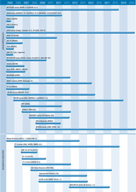
A range of instruments with thermal bands are being used for SST measurements. Visible/infrared imagers such as AVHRR, AATSR, and MODIS currently provide the main source of SST data, with AATSR and MODIS providing better accuracy (0.25–0.3K) – but AVHRR giving greater coverage, enabling it to track ocean currents, and to monitor ENSO phenomena through its larger swath width. The Aqua mission, which includes MODIS along with AIRS+ and AMSR provides oceanographers with further precise information and the ability to remove atmospheric effects. NOAA’s VIIRS and CMIS instruments on the planned NPOESS missions will provide capabilities to produce higher resolution and more accurate measurements of SST than currently available from AVHRR. Future sources of SST data include: AMSR-E on Aqua; the SEVIRI and IASI instruments on the METEOSAT-8/MSG and METOP missions respectively.
Reviewing supply of SST observations, the IGOS Ocean Theme Team was reassured about continuity of SST data from operational meteorological satellites, but noted that continuity beyond the Envisat mission for the AATSR class of instrument was not assured and urged consideration of how AATSR-class instruments could be introduced into operational systems.

