Ocean surface winds
High resolution vector wind measurements at the sea surface are required in models of the atmosphere, ocean surface waves, and ocean circulation. They are proving useful in enhancing marine weather forecasting through assimilation into NWP models and in improving understanding of the large-scale air-sea fluxes which are vital for climate prediction purposes. Accurate wind vector data affect a broad range of marine operations, including offshore oil operations, ship movement and routing. Such data also aid short-term weather forecasting and the issue of timely weather warnings.
Polar orbiting satellites provide information on surface wind with global coverage, good horizontal resolution and acceptable accuracy, though temporal frequency is marginal for regional mesoscale forecasts. They provide useful information in two ways:
- scatterometers provide dense observations of wind direction and speed along a narrow swath, although the most recent and planned scatterometers provide better coverage via broader swaths (90% global coverage daily); scatterometers have made a positive impact in predicting marine forecasting, operational global NWP and climate forecasting;
- passive microwave imagers provide information on wind speed only.
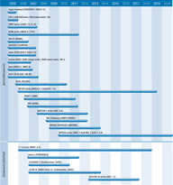
The single swath scatterometer on ERS-2 and the broad swath scatterometer on QuickSCAT currently provide adequate coverage. QuickSCAT, launched in 1999, carries the SeaWinds scatterometer that measures near surface wind speed and direction in all weather and cloud conditions. Global coverage by a broad swath scatterometer will be provided by ASCAT on the METOP missions. Developed by ESA as a follow-on from the ‘wind mode’ of the AMI on the ERS series, ASCAT will be used primarily for global measurement of sea surface wind vectors and will be able to provide quasi-global coverage within 24 hours. AMSR-E on Aqua also provides data on sea surface wind speed.
The operational NPOESS missions, will use the CMIS instrument, which employs a passive microwave approach for collecting data on sea surface winds.
In recent years, the ability to detect and track severe storms has been dramatically enhanced by the advent of weather satellites. Data from SeaWinds is augmenting traditional satellite images of clouds by providing direct measurements of surface winds enabling better determination of a storm’s location, direction, structure and strength.

