Potential Midlatitude Forecast Errors Without MODIS Polar Winds: Niels Bormann of ECMWF provided a case study that showed how errors in forecasts can propogate from the Arctic to the midlatitudes when the MODIS polar winds data are not used in the initial analysis. In the experiment, an area of large differences in the 500 hPa geopotential height between forecasts with and without MODIS winds propagated from the Beaufort Sea north of Alaska to the Gulf of Alaska and the north Pacific Ocean over a 5-day period.
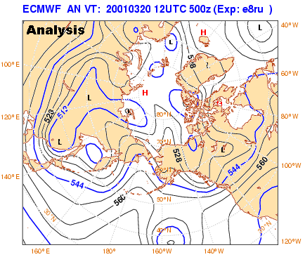
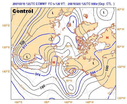
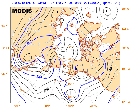
The figures below show the 500 hPa height analysis for March 20, 2002 (top), the 5-day forecast when MODIS winds were not assimilated (the control run, middle), and the 5-day forecast for the run that assimilated the MODIS winds. The MODIS forecast is much closer to "truth" than the control run, particularly over Alaska.
Another way to look at the difference between the runs with and without the MODIS winds is to examine the differences between the 500 hPa geopotential heights in the forecasts. The animation below shows the propagation of analysis errors from the poles to the midlatitudes for the same case as above. Each frame shows the 500 hPa geopotential height for forecasts from 1 to 5 days in 1 day increments. The solid blue line is the geopotential from the experiment that included MODIS winds; the dashed black line is the control (CTL) experiment without MODIS winds. Solid red lines show positive differences in the geopotential height (MODIS minus CTL), and thick dashed green lines show negative differences. The area of large positive differences near the Beaufort Sea north of Alaska moves southward over the 5-day period. The control run is forming a deeper trough than the MODIS run over central Alaska and then over the Pacific Ocean south of Alaska.
![]()
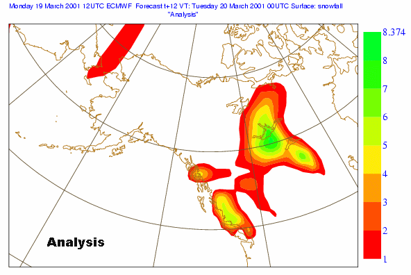
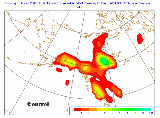
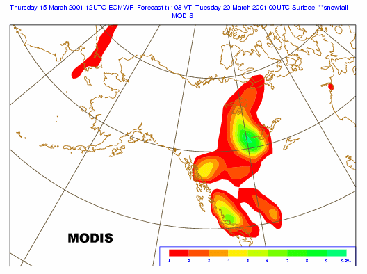
How does this error in the 500 hPa geopotential height impact the weather? One example is in the accumulated snowfall. The figures below show the accumulated snowfall forecasts (mm water equivalent) over Alaska for 03/20/02 (end of animation period). The first figure is the snowfall from a 12-hr forecast for verification ("truth"). The second figure is the snowfall from the 5-day control forecast (no MODIS winds). The last figure is the snowfall from the 5-day MODIS forecast. The control run produced spurious snowfall in southern Alaska.
This case demonstrates the potential (though not necessarily the maximum) error. It is not yet known how typical this type of forecast error is. But the implication of this study is that better observations over the poles can improve forecasts in the midlatitudes.
